Dix's Grant, New Hampshire facts for kids
Quick facts for kids
Dix's Grant, New Hampshire
|
|
|---|---|

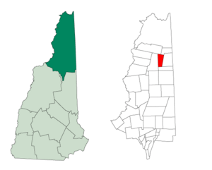
Location in Coös County, New Hampshire
|
|
| Country | United States |
| State | New Hampshire |
| County | Coös |
| Area | |
| • Total | 20.1 sq mi (52.0 km2) |
| • Land | 20.0 sq mi (51.9 km2) |
| • Water | 0.04 sq mi (0.1 km2) 0.21% |
| Elevation | 2,120 ft (650 m) |
| Population
(2020)
|
|
| • Total | 0 |
| Time zone | UTC-5 (Eastern) |
| • Summer (DST) | UTC-4 (Eastern) |
| Area code(s) | 603 |
| FIPS code | 33-007-18340 |
| GNIS feature ID | 871113 |
Dix's Grant is a special kind of area called a township in Coös County, New Hampshire. It's in the northeastern part of the United States. What makes Dix's Grant unique is that, according to the 2020 census, no one lives there!
In New Hampshire, "grants" and "townships" are areas that are not part of any regular town. They have very little or no local government. Dix's Grant is one of these quiet, uninhabited places.
This area will be a great spot to see the total solar eclipse of April 8, 2024. During a total solar eclipse, the Moon completely blocks the Sun, making the sky dark in the middle of the day.
Contents
The Story of Dix's Grant
Dix's Grant was once part of a larger area called Dixville. In 1805, the government gave this land to a person named Timothy Dix Jr. He paid $4,500 for about 29,340 acres (118.7 square kilometers) of land.
Later, the eastern part of this original land became what we now know as Dix's Grant. This happened sometime around August 2019.
Exploring the Geography
Dix's Grant covers about 52.0 square kilometers (20.1 square miles). Most of this area is land, with only a tiny bit, about 0.11 square kilometers (0.04 square miles), covered by water.
Two rivers, the Swift Diamond River and its smaller stream, Fourmile Brook, flow through this township. The Swift Diamond River flows east and joins the Dead Diamond River. Both of these rivers are part of the larger Androscoggin River system.
The highest point in Dix's Grant is a spot on the ridge of Crystal Mountain. It stands tall at about 3,279 feet (999 meters) above sea level.
Nearby Places
Dix's Grant is surrounded by several other interesting areas:
- Atkinson and Gilmanton Academy Grant (to the northeast)
- Second College Grant (to the east)
- Wentworth Location (to the south)
- Dixville (to the west)
- Clarksville (to the northwest)
Understanding the Climate
Crystal Mountain is a mountain ridge located right in Dix's Grant. The climate here is mostly a humid continental climate (which means it has warm summers and cold winters). It's also very close to a subarctic climate, which means it can get extremely cold with long, harsh winters.
| Climate data for Crystal Mountain 44.9445 N, 71.2098 W, Elevation: 3,117 ft (950 m) (1991–2020 normals) | |||||||||||||
|---|---|---|---|---|---|---|---|---|---|---|---|---|---|
| Month | Jan | Feb | Mar | Apr | May | Jun | Jul | Aug | Sep | Oct | Nov | Dec | Year |
| Mean daily maximum °F (°C) | 19.0 (−7.2) |
21.4 (−5.9) |
29.8 (−1.2) |
43.8 (6.6) |
57.0 (13.9) |
65.9 (18.8) |
70.3 (21.3) |
69.2 (20.7) |
62.4 (16.9) |
49.1 (9.5) |
35.3 (1.8) |
25.3 (−3.7) |
45.7 (7.6) |
| Daily mean °F (°C) | 9.6 (−12.4) |
11.4 (−11.4) |
19.8 (−6.8) |
34.3 (1.3) |
46.2 (7.9) |
55.5 (13.1) |
59.9 (15.5) |
58.6 (14.8) |
51.8 (11.0) |
40.0 (4.4) |
28.2 (−2.1) |
17.2 (−8.2) |
36.0 (2.3) |
| Mean daily minimum °F (°C) | 0.1 (−17.7) |
1.3 (−17.1) |
9.9 (−12.3) |
24.9 (−3.9) |
35.4 (1.9) |
45.0 (7.2) |
49.5 (9.7) |
48.1 (8.9) |
41.3 (5.2) |
30.9 (−0.6) |
21.0 (−6.1) |
9.2 (−12.7) |
26.4 (−3.1) |
| Average precipitation inches (mm) | 4.28 (109) |
3.57 (91) |
4.16 (106) |
4.28 (109) |
5.05 (128) |
5.95 (151) |
5.60 (142) |
5.40 (137) |
4.56 (116) |
5.66 (144) |
4.54 (115) |
4.79 (122) |
57.84 (1,470) |
| Source: PRISM Climate Group | |||||||||||||
Population Numbers
A census is like a big count of all the people living in an area. It happens every ten years. Here's how the population of Dix's Grant has changed over time:
| Historical population | |||
|---|---|---|---|
| Census | Pop. | %± | |
| 1910 | 33 | — | |
| 1960 | 0 | — | |
| 1970 | 0 | — | |
| 1980 | 0 | — | |
| 1990 | 0 | — | |
| 2000 | 0 | — | |
| 2010 | 1 | — | |
| 2020 | 0 | −100.0% | |
| U.S. Decennial Census | |||
As you can see from the table, Dix's Grant has been mostly uninhabited for many years. In the 2010 census, there was just one person living there. However, by the 2020 census, the population was back to zero.
See also
 In Spanish: Dix's Grant para niños
 | James Van Der Zee |
 | Alma Thomas |
 | Ellis Wilson |
 | Margaret Taylor-Burroughs |

