Upper Ammonoosuc River facts for kids
Quick facts for kids Upper Ammonoosuc River |
|
|---|---|

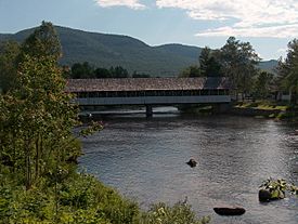
The Upper Ammonoosuc at the covered bridge in Stark, New Hampshire
|
|
| Country | United States |
| State | New Hampshire |
| County | Coos |
| Towns and city | Randolph, Berlin, Milan, Dummer, Stark, Northumberland |
| Physical characteristics | |
| Main source | Pond of Safety Randolph 2,190 ft (667.5 m) 44°24′31″N 71°20′22″W / 44.40861°N 71.33944°W |
| River mouth | Connecticut River Groveton 845 ft (258 m) 44°35′18″N 71°32′4″W / 44.58833°N 71.53444°W |
| Length | 42.4 mi (68.2 km) |
| Basin features | |
| Tributaries |
|
The Upper Ammonoosuc River is a river in New Hampshire, a state in the United States. It flows through Coos County in the northern part of the state. This river is a "tributary" of the Connecticut River. This means it's a smaller river that flows into a larger one.
Even though its name sounds like the Ammonoosuc River, they are actually two different rivers. The Upper Ammonoosuc River flows into the Connecticut River much further north.
Contents
Where Does the River Start and End?
The Upper Ammonoosuc River begins in a place called Pond of Safety. This pond is located in the town of Randolph.
The River's Journey
From its start, the river first flows north. It passes through rural areas like Berlin. In Berlin, it flows through the Godfrey Dam. It then continues through Milan and a small part of Dummer.
After that, the river turns west. It flows through the town of Stark. Finally, it reaches Northumberland. Here, it joins the larger Connecticut River near the village of Groveton.
The river's total length is about 42.4 miles (68.2 kilometers). For much of its journey from Milan to Groveton, you can see it running alongside New Hampshire Route 110.
History Along the River
An important historical site called Fort Wentworth was built in 1755. This fort was located right where the Upper Ammonoosuc River meets the Connecticut River. Today, this spot is near the village of Groveton.
The fort was used at different times during two major wars:
What Areas Does the River Drain?
The Upper Ammonoosuc River and its smaller streams collect water from a large area. This area is called its "watershed." The watershed includes parts of the White Mountains.
Main Streams Joining the River
Several smaller streams flow into the Upper Ammonoosuc River. These are called tributaries. Some of the main ones include:
- Nash Stream: This stream starts in the area known as Odell.
- Phillips Brook: This brook begins in Erving's Location.
- The North Branch of the Upper Ammonoosuc: This stream flows mostly parallel to the main river in Milan. It joins the main river at West Milan.
- The West Branch of the Upper Ammonoosuc: This branch starts on the eastern side of Mount Cabot in Kilkenny. It collects water from Unknown Pond and York Pond before joining the main river below the Godfrey Dam.
 | Tommie Smith |
 | Simone Manuel |
 | Shani Davis |
 | Simone Biles |
 | Alice Coachman |


