Odell, New Hampshire facts for kids
Quick facts for kids
Odell, New Hampshire
|
|
|---|---|

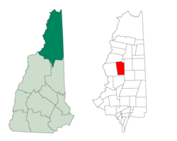
Location in Coös County, New Hampshire
|
|
| Country | United States |
| State | New Hampshire |
| County | Coös |
| Area | |
| • Total | 45.0 sq mi (116.6 km2) |
| • Land | 44.3 sq mi (114.8 km2) |
| • Water | 0.7 sq mi (1.8 km2) 1.53% |
| Elevation | 3,110 ft (950 m) |
| Population
(2020)
|
|
| • Total | 1 |
| • Density | 0.03/sq mi (0.01/km2) |
| Time zone | UTC-5 (Eastern) |
| • Summer (DST) | UTC-4 (Eastern) |
| Area code(s) | 603 |
| FIPS code | 33-007-57860 |
| GNIS feature ID | 873691 |
Odell is a special kind of area called a township in Coös County, New Hampshire, United States. Unlike a regular town, townships in New Hampshire are usually unincorporated. This means they are not part of any town and have very little or no self-government. According to the 2020 census, only one person lives in Odell.
History of Odell
Odell township got its name from a man named Richard Odell. He was from Conway. In 1834, Richard Odell bought a large piece of land, about 23,751 acres (96.1 km2), from the state for $1,863. That's how the area got its name!
Exploring Odell's Geography
A big part of Odell township is covered by the Nash Stream Forest. This is a large area of state-owned land. There are three main mountains in Odell. Each of these mountains is taller than 3,000 feet (914 meters). They are called Muise Mountain, Whitcomb Mountain, and Long Mountain. The two highest points in Odell are the two tops of Long Mountain. They are both 3,661 feet (1,116 meters) above sea level.
Odell doesn't have many paved roads or highways. Most roads are rough and unpaved. The western part of the township has water that flows into Nash Stream. The eastern part drains into Phillips Brook. Both of these streams flow south. They eventually join the Upper Ammonoosuc River. All this water is part of the larger Connecticut River watershed. A watershed is an area of land where all the water drains into a single river or body of water.
Nearby Places
Odell is surrounded by several other towns and locations:
- Erving's Location (to the northeast)
- Millsfield (to the east)
- Dummer (to the southeast)
- Stark (to the south)
- Stratford (to the west)
- Columbia (to the northwest)
Who Lives in Odell?
| Historical population | |||
|---|---|---|---|
| Census | Pop. | %± | |
| 1860 | 1 | — | |
| 1920 | 73 | — | |
| 1930 | 0 | −100.0% | |
| 1940 | 82 | — | |
| 1950 | 12 | −85.4% | |
| 1960 | 0 | −100.0% | |
| 1970 | 3 | — | |
| 1980 | 0 | −100.0% | |
| 1990 | 0 | — | |
| 2000 | 5 | — | |
| 2010 | 4 | −20.0% | |
| 2020 | 1 | −75.0% | |
| U.S. Decennial Census | |||
Odell has always had a very small population. Sometimes, no one lives there at all! For example, in 1930 and 1960, the census recorded zero people.
In the year 2000, there were 5 people living in Odell. These 5 people made up 4 households. Only one of these households was a married couple. The others were individuals living alone. Two of the people living alone were 65 years old or older. The average household size was small, with about 1.25 people per home.
The population was spread out in terms of age. There was one person aged 18-24, one aged 25-44, one aged 45-64, and two people who were 65 or older. The average age was 50 years old.
By the 2020 census, the population had dropped to just one person. This makes Odell one of the least populated areas in New Hampshire.
See also
 In Spanish: Odell (Nuevo Hampshire) para niños
 | Tommie Smith |
 | Simone Manuel |
 | Shani Davis |
 | Simone Biles |
 | Alice Coachman |

