Columbia, New Hampshire facts for kids
Quick facts for kids
Columbia, New Hampshire
|
|
|---|---|
|
Town
|
|

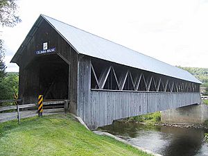
Columbia Covered Bridge, built in 1912
|
|

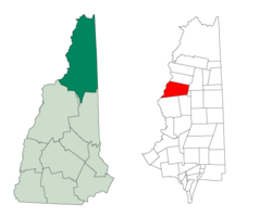
Location in Coös County, New Hampshire
|
|
| Country | United States |
| State | New Hampshire |
| County | Coös |
| Incorporated | 1797 |
| Villages |
|
| Area | |
| • Total | 61.1 sq mi (158.3 km2) |
| • Land | 60.8 sq mi (157.4 km2) |
| • Water | 0.3 sq mi (0.9 km2) 0.55% |
| Elevation | 1,024 ft (312 m) |
| Population
(2020)
|
|
| • Total | 659 |
| • Density | 11/sq mi (4.2/km2) |
| Time zone | UTC-5 (Eastern) |
| • Summer (DST) | UTC-4 (Eastern) |
| ZIP codes | |
| Area code(s) | 603 |
| FIPS code | 33-13940 |
| GNIS feature ID | 0873568 |
Columbia is a small town in Coös County, New Hampshire, in the United States. It's a quiet place with a population of 659 people, according to the 2020 census. This number was a bit lower than in 2010, when 757 people lived there. Columbia is part of the wider Berlin, New Hampshire area.
Contents
History of Columbia
The area that is now Columbia was first given a special paper (called a charter) in 1762. It was named "Preston" back then. This name honored Richard Graham, who was a viscount from Scotland. However, the first settlers didn't follow the rules of the original grant.
So, in 1770, the land was given to new owners, including Sir James Cockburn. Because of him, the town was then called "Cockburn Town." It officially became a town on December 16, 1797. Later, in 1811, before the War of 1812 started, Governor John Langdon changed the name again. He renamed it Columbia, which is a poetic name for America.
Even though the land in Columbia is hilly and has mountains, the soil was good for farming. People started making maple sugar, which became an important product. They also cut down trees for lumber. This wood was then floated on rafts down the Connecticut River to be sold in other towns. By 1859, when 762 people lived in Columbia, the town had four sawmills (for cutting wood), three gristmills (for grinding grain), two machines for making clapboard (a type of siding for houses), and a factory for making starch.
Geography and Landscape
Columbia covers about 158.3 square kilometers (about 61.1 square miles). Most of this area is land (157.4 sq km), with a small part being water (0.9 sq km). The town has two main streams, the east and west branches of Simms Stream.
The highest point in Columbia is the top of Blue Mountain. This mountain reaches about 1,024 meters (3,720 feet) above sea level. All the water in Columbia eventually flows into the Connecticut River.
Nearby Towns
Columbia shares its borders with several other towns:
- Colebrook (to the north)
- Dixville (to the northeast)
- Erving's Location (to the southeast)
- Odell (to the southeast)
- Stratford (to the south)
- Bloomfield, Vermont (to the southwest)
- Lemington, Vermont (to the northwest)
Climate in Columbia
The climate in Columbia, especially around Blue Mountain, is a humid continental climate. This means it has warm summers and cold, snowy winters. Sometimes, it can even feel like a subarctic climate, which is even colder.
Population Changes
| Historical population | |||
|---|---|---|---|
| Census | Pop. | %± | |
| 1790 | 26 | — | |
| 1800 | 109 | 319.2% | |
| 1810 | 142 | 30.3% | |
| 1820 | 249 | 75.4% | |
| 1830 | 442 | 77.5% | |
| 1840 | 620 | 40.3% | |
| 1850 | 762 | 22.9% | |
| 1860 | 798 | 4.7% | |
| 1870 | 752 | −5.8% | |
| 1880 | 762 | 1.3% | |
| 1890 | 605 | −20.6% | |
| 1900 | 690 | 14.0% | |
| 1910 | 619 | −10.3% | |
| 1920 | 601 | −2.9% | |
| 1930 | 524 | −12.8% | |
| 1940 | 483 | −7.8% | |
| 1950 | 495 | 2.5% | |
| 1960 | 457 | −7.7% | |
| 1970 | 467 | 2.2% | |
| 1980 | 673 | 44.1% | |
| 1990 | 661 | −1.8% | |
| 2000 | 750 | 13.5% | |
| 2010 | 757 | 0.9% | |
| 2020 | 659 | −12.9% | |
| U.S. Decennial Census | |||
Over the years, the number of people living in Columbia has changed quite a bit. In 1790, there were only 26 people! The population grew steadily for many years, reaching its highest point in 1860 with 798 residents. After that, the population went up and down. In 2020, there were 659 people living in Columbia.
In 2000, there were 750 people living in Columbia. About 31.7% of the homes had children under 18. The average age of people in Columbia was 42 years old.
Notable Person from Columbia
- Alma Carrie Cummings (1857–1926) was an American journalist who was also a newspaper editor and owner. She was born in Columbia.
See also
In Spanish: Columbia (Nuevo Hampshire) para niños
 | John T. Biggers |
 | Thomas Blackshear |
 | Mark Bradford |
 | Beverly Buchanan |

