Bloomfield, Vermont facts for kids
Quick facts for kids
Bloomfield, Vermont
|
|
|---|---|
|
Town
|
|
 |
|

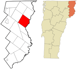
Location in Essex County and the state of Vermont.
|
|

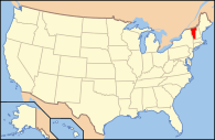
Location of Vermont with the U.S.A.
|
|
| Country | United States |
| State | Vermont |
| County | Essex |
| Area | |
| • Total | 40.5 sq mi (105.0 km2) |
| • Land | 40.3 sq mi (104.4 km2) |
| • Water | 0.2 sq mi (0.6 km2) |
| Elevation | 1,804 ft (550 m) |
| Population
(2020)
|
|
| • Total | 217 |
| • Density | 5/sq mi (2.1/km2) |
| • Households | 101 |
| • Families | 75 |
| Time zone | UTC-5 (EST) |
| • Summer (DST) | UTC-4 (EDT) |
| ZIP code |
05905
|
| Area code(s) | 802 |
| FIPS code | 50-009-06325 |
| GNIS feature ID | 1462044 |
Bloomfield is a small town located in Essex County, Vermont, in the United States. In 2020, about 217 people lived there. It is part of a larger area that includes Berlin, New Hampshire, and parts of Vermont.
Contents
History of Bloomfield
Bloomfield has an interesting past.
- In 1830, the town's name was officially changed from "Minehead" to "Bloomfield." This change was made by the state's General Assembly.
- Later, in 1849, the Nulhegan Mill was built. This mill created many new jobs and helped the town's population grow.
Geography of Bloomfield
Bloomfield is located in the northeastern part of Essex County.
- It sits along the Connecticut River, which forms the border between Vermont and New Hampshire.
- Neighboring towns include Brunswick to the southwest, Lewis to the northwest, and Lemington, Vermont to the northeast.
- Across the river in New Hampshire, you'll find the towns of Columbia and Stratford, New Hampshire.
The main settlement of Bloomfield is in the southern part of the town. It's where the Nulhegan River flows into the Connecticut River. A bridge connects Bloomfield to the village of North Stratford, New Hampshire.
Roads in Bloomfield
- Vermont Route 102 runs along the Connecticut River on the southeastern side of town. It goes northeast about 13 miles to Colebrook, New Hampshire. It also goes south about 15 miles to Guildhall, Vermont.
- Vermont Route 105 heads west from Bloomfield, following the Nulhegan River. It leads about 16 miles to Island Pond.
Land and Water
The United States Census Bureau says that Bloomfield covers a total area of about 105 square kilometers (about 40.5 square miles).
- Most of this area, about 104.4 square kilometers (40.3 square miles), is land.
- Only a small part, about 0.6 square kilometers (0.2 square miles), is water.
- The highest point in Bloomfield is about 2,470 feet high, found along the town's northeast border.
- Even though much of the town is at a high elevation, most people live closer to the river where the land is lower.
Climate in Bloomfield
Bloomfield can get very cold!
- A weather station operated in the town from 1906 to 1968. It was located near Lyman Falls, by the Connecticut River.
- On December 30, 1933, Bloomfield set a record for the coldest temperature ever recorded in New England. It dropped to an amazing -50 degrees Fahrenheit (-46 degrees Celsius)!
- This record was only tied once, in 2009, by a small station in Maine.
| Climate data for Bloomfield (1906–1968); elevation 940 feet | |||||||||||||
|---|---|---|---|---|---|---|---|---|---|---|---|---|---|
| Month | Jan | Feb | Mar | Apr | May | Jun | Jul | Aug | Sep | Oct | Nov | Dec | Year |
| Record high °F (°C) | 62 (17) |
68 (20) |
78 (26) |
87 (31) |
96 (36) |
25 (−4) |
98 (37) |
97 (36) |
98 (37) |
88 (31) |
75 (24) |
62 (17) |
98 (37) |
| Mean daily maximum °F (°C) | 27 (−3) |
29 (−2) |
39 (4) |
52 (11) |
66 (19) |
76 (24) |
80 (27) |
78 (26) |
70 (21) |
59 (15) |
43 (6) |
30 (−1) |
55 (13) |
| Mean daily minimum °F (°C) | 3 (−16) |
3 (−16) |
14 (−10) |
28 (−2) |
38 (3) |
48 (9) |
53 (12) |
51 (11) |
44 (7) |
34 (1) |
24 (−4) |
10 (−12) |
29 (−2) |
| Record low °F (°C) | −44 (−42) |
−45 (−43) |
−32 (−36) |
−12 (−24) |
14 (−10) |
— | 30 (−1) |
23 (−5) |
20 (−7) |
6 (−14) |
−15 (−26) |
−50 (−46) |
−50 (−46) |
| Average precipitation inches (mm) | 2.3 (58) |
2.0 (51) |
2.2 (56) |
2.9 (74) |
3.2 (81) |
4.0 (100) |
4.1 (100) |
3.9 (99) |
3.7 (94) |
3.5 (89) |
3.2 (81) |
2.5 (64) |
37.8 (960) |
| Average snowfall inches (cm) | 23.0 (58) |
20.6 (52) |
15.0 (38) |
5.1 (13) |
0.4 (1.0) |
0 (0) |
0 (0) |
0 (0) |
0 (0) |
1.3 (3.3) |
8.7 (22) |
18.3 (46) |
92.4 (233.3) |
| Source: Desert Research Institute | |||||||||||||
People of Bloomfield
Here's a look at the population changes and other facts about the people living in Bloomfield.
| Historical population | |||
|---|---|---|---|
| Census | Pop. | %± | |
| 1800 | 27 | — | |
| 1810 | 144 | 433.3% | |
| 1820 | 132 | −8.3% | |
| 1830 | 150 | 13.6% | |
| 1840 | 179 | 19.3% | |
| 1850 | 244 | 36.3% | |
| 1860 | 320 | 31.1% | |
| 1870 | 455 | 42.2% | |
| 1880 | 627 | 37.8% | |
| 1890 | 827 | 31.9% | |
| 1900 | 504 | −39.1% | |
| 1910 | 496 | −1.6% | |
| 1920 | 382 | −23.0% | |
| 1930 | 417 | 9.2% | |
| 1940 | 326 | −21.8% | |
| 1950 | 291 | −10.7% | |
| 1960 | 212 | −27.1% | |
| 1970 | 196 | −7.5% | |
| 1980 | 188 | −4.1% | |
| 1990 | 253 | 34.6% | |
| 2000 | 261 | 3.2% | |
| 2010 | 221 | −15.3% | |
| 2020 | 217 | −1.8% | |
| U.S. Decennial Census | |||
Population in 2000
According to the 2000 census:
- There were 261 people living in Bloomfield.
- These people lived in 101 households, and 75 of these were families.
- Most residents (about 95.4%) were White. There were also Native American, Asian, and people of two or more races.
Households and Families
- About 34.7% of households had children under 18 living with them.
- Most households (61.4%) were married couples living together.
- About 23.8% of households were single people living alone. Of these, 13.9% were people aged 65 or older.
- The average household had about 2.58 people, and the average family had about 3.03 people.
Age and Income
- About 27.2% of the population was under 18 years old.
- The median age (the middle age of all people) was 39 years old.
- The median income for a household was $33,500. This means half of the households earned more, and half earned less.
- The median income for families was $39,167.
See also
 In Spanish: Bloomfield (Vermont) para niños
 | Precious Adams |
 | Lauren Anderson |
 | Janet Collins |

