Brunswick, Vermont facts for kids
Quick facts for kids
Brunswick, Vermont
|
|
|---|---|
|
Town
|
|

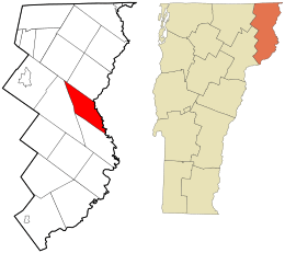
Location in Essex County and the state of Vermont.
|
|

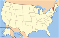
Location of Vermont in the United States
|
|
| Country | United States |
| State | Vermont |
| County | Essex |
| Chartered | 1761 |
| Settled | 1780 |
| Area | |
| • Total | 26.0 sq mi (67.3 km2) |
| • Land | 25.5 sq mi (66.0 km2) |
| • Water | 0.5 sq mi (1.4 km2) |
| Elevation | 1,030 ft (314 m) |
| Population
(2020)
|
|
| • Total | 88 |
| • Density | 3/sq mi (1.3/km2) |
| • Households | 40 |
| • Families | 28 |
| Time zone | UTC-5 (EST) |
| • Summer (DST) | UTC-4 (EDT) |
| ZIP code |
05905
|
| Area code(s) | 802 |
| FIPS code | 50-10075 |
| GNIS feature ID | 1462057 |
Brunswick is a small town located in Essex County, Vermont, in the United States. It was named after Prince Karl Wilhelm Ferdinand of Brunswick-Lunenburg. In 2020, the town had a population of 88 people. It is part of the larger Berlin, NH-VT Micropolitan Statistical Area. Brunswick is special because it has six mineral springs. These springs made the town a popular place to visit in the 1800s. Today, the land where these springs are located is owned by the Abenaki people.
Where is Brunswick?
Brunswick is found on the eastern side of Essex County. It shares a border with the Connecticut River, which is a natural boundary between Vermont and New Hampshire. To the south of Brunswick is the town of Maidstone. To the west, you'll find Ferdinand, and to the northwest is Lewis. Bloomfield is to the north. Across the Connecticut River to the east is the town of Stratford, New Hampshire.
The United States Census Bureau says that Brunswick covers a total area of about 67.3 square kilometers (26.0 square miles). Most of this area, 66.0 square kilometers (25.5 square miles), is land. The remaining 1.4 square kilometers (0.5 square miles), or about 2.03%, is water.
How Many People Live Here?
Brunswick has always been a small town. The number of people living there has changed over many years. Here is a look at the population from different census years:
| Historical population | |||
|---|---|---|---|
| Census | Pop. | %± | |
| 1790 | 66 | — | |
| 1800 | 86 | 30.3% | |
| 1810 | 143 | 66.3% | |
| 1820 | 124 | −13.3% | |
| 1830 | 160 | 29.0% | |
| 1840 | 130 | −18.7% | |
| 1850 | 119 | −8.5% | |
| 1860 | 212 | 78.2% | |
| 1870 | 221 | 4.2% | |
| 1880 | 193 | −12.7% | |
| 1890 | 160 | −17.1% | |
| 1900 | 166 | 3.8% | |
| 1910 | 82 | −50.6% | |
| 1920 | 89 | 8.5% | |
| 1930 | 73 | −18.0% | |
| 1940 | 86 | 17.8% | |
| 1950 | 73 | −15.1% | |
| 1960 | 62 | −15.1% | |
| 1970 | 45 | −27.4% | |
| 1980 | 82 | 82.2% | |
| 1990 | 92 | 12.2% | |
| 2000 | 107 | 16.3% | |
| 2010 | 112 | 4.7% | |
| 2020 | 88 | −21.4% | |
| U.S. Decennial Census | |||
In the year 2000, there were 107 people living in Brunswick. There were 40 households and 28 families. The town had about 4.2 people per square mile (1.6 people per square kilometer). Most of the people living in Brunswick were White.
The average age of people in Brunswick in 2000 was 40 years old. About 29.9% of the population was under 18 years old.
See also
 In Spanish: Brunswick (Vermont) para niños
 | William L. Dawson |
 | W. E. B. Du Bois |
 | Harry Belafonte |

