Essex County, Vermont facts for kids
Quick facts for kids
Essex County
|
|
|---|---|

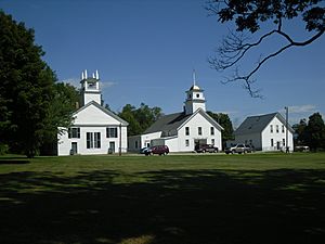
Essex County Courthouse in Guildhall
|
|

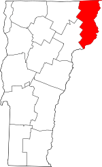
Location within the U.S. state of Vermont
|
|
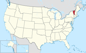
 Vermont's location within the U.S. |
|
| Country | |
| State | |
| Founded | 1800 |
| Named for | Essex |
| Shire Town | Guildhall |
| Largest town | Lunenburg |
| Area | |
| • Total | 675 sq mi (1,750 km2) |
| • Land | 664 sq mi (1,720 km2) |
| • Water | 12 sq mi (30 km2) 1.7%% |
| Population
(2020)
|
|
| • Total | 5,920 |
| • Density | 8.770/sq mi (3.386/km2) |
| Time zone | UTC−5 (Eastern) |
| • Summer (DST) | UTC−4 (EDT) |
| Congressional district | At-large |
Essex County is a county in the U.S. state of Vermont. It is located in the northeastern part of the state, an area often called the Northeast Kingdom. In 2020, about 5,920 people lived here. This makes it the county with the fewest people in both Vermont and New England.
The main town, also called the county seat, is Guildhall. Essex County was created in 1792 and officially started in 1800. It shares a border with the Connecticut River and New Hampshire. To the north, it borders the Canadian province of Quebec. Essex County has the lowest average household income in Vermont.
Contents
History of Essex County
Before European settlers arrived, the local Abenakis people lived in this area. They often hunted moose for food.
Vermont was first divided into two counties in March 1778. Later, in 1781, the northernmost county, Cumberland, was split into three new counties. These were Windham, Windsor, and Orange County.
On September 3, 1783, the Treaty of Paris was signed. This treaty ended the Revolutionary War. Great Britain officially recognized the United States as an independent country. At this time, Vermont's border with Quebec was set at the 45 degrees north latitude.
On November 5, 1792, the Vermont legislature divided Chittenden and Orange counties. They created six new counties: Chittenden, Orange, Franklin, Caledonia, Essex, and Orleans. The reason why Essex County was named after Essex in England is not known.
In 1999, a group of investors bought a large piece of land. They purchased 86,212 acres from a company called Champion International Paper for $7.5 million. This land covered parts of fourteen towns in Essex County. The state of Vermont and the Freeman Foundation later bought special rights to this land for $8.5 million. This was done to make sure the land could still be used for traditional activities like logging and recreation. In 2008, another company, Plum Creek Timber, announced plans to buy this property.
Population Information
| Historical population | |||
|---|---|---|---|
| Census | Pop. | %± | |
| 1800 | 1,479 | — | |
| 1810 | 3,087 | 108.7% | |
| 1820 | 3,284 | 6.4% | |
| 1830 | 3,981 | 21.2% | |
| 1840 | 4,226 | 6.2% | |
| 1850 | 4,650 | 10.0% | |
| 1860 | 5,786 | 24.4% | |
| 1870 | 6,811 | 17.7% | |
| 1880 | 7,931 | 16.4% | |
| 1890 | 9,511 | 19.9% | |
| 1900 | 8,056 | −15.3% | |
| 1910 | 7,384 | −8.3% | |
| 1920 | 7,364 | −0.3% | |
| 1930 | 7,067 | −4.0% | |
| 1940 | 6,490 | −8.2% | |
| 1950 | 6,257 | −3.6% | |
| 1960 | 6,083 | −2.8% | |
| 1970 | 5,416 | −11.0% | |
| 1980 | 6,313 | 16.6% | |
| 1990 | 6,405 | 1.5% | |
| 2000 | 6,459 | 0.8% | |
| 2010 | 6,306 | −2.4% | |
| 2020 | 5,920 | −6.1% | |
| U.S. Decennial Census 1790–1960 1900–1990 1990–2000 2010–2020 |
|||
2010 Census Details
In 2010, there were 6,306 people living in Essex County. These people lived in 2,818 households, and 1,814 of these were families. The county had about 9.5 people per square mile. There were also 5,019 housing units.
About 24.2% of households had children under 18 living with them. About 51.0% were married couples. The average age of people in the county was 47.4 years old.
The average income for a household in the county was $37,734. For families, the average income was $46,263.
Geography
The U.S. Census Bureau says that Essex County covers a total area of 675 square miles. Most of this, 664 square miles, is land. The remaining 12 square miles, or 1.7%, is water.
Neighboring Counties
Essex County shares borders with several other counties:
- Coos County, New Hampshire – to the east
- Grafton County, New Hampshire – to the south
- Caledonia County – to the southwest
- Orleans County – to the west
- Coaticook Regional County Municipality, Quebec – to the north (in Canada)
Main Roads
Important roads that go through Essex County include:
- U.S. Route 2
- Vermont Route 102
- Vermont Route 105
- Vermont Route 114
Wildlife: Moose Population
In 2011, there were about 1,000 moose living in Essex County. State officials believed this was a good number for the moose population to stay healthy. The moose were not showing signs of being hungry, and their feeding areas were not being overused.
Protected Natural Areas
Part of the Silvio O. Conte National Fish and Wildlife Refuge is located in Essex County. This area helps protect wildlife.
Economy
Income and Wages
In Essex County, the average household income was $30,490. For families, the average income was $34,984. The average wage in Essex County is the lowest in the state of Vermont. This situation was expected to continue for some time.
Housing Affordability
In 2007, Essex was the only county in Vermont where the average family could afford to buy the average house. This is called a positive Housing Affordability Index. Both the average house price and the average income were the lowest in the state.
Media
WVTI 106.9 is a radio station that broadcasts from Island Pond, Vermont, which is in Essex County.
Communities
Towns
Census-Designated Places (CDPs)
These are areas that are like towns but are not officially incorporated as towns.
Unincorporated Communities
These are small settlements that are not part of any official town.
In Vermont, there are also special areas called gores and grants. These are parts of a county that are not part of any town. They have very limited self-government, and many of them are not lived in.
See also
 In Spanish: Condado de Essex (Vermont) para niños
 | DeHart Hubbard |
 | Wilma Rudolph |
 | Jesse Owens |
 | Jackie Joyner-Kersee |
 | Major Taylor |

