Caledonia County, Vermont facts for kids
Quick facts for kids
Caledonia County
|
|
|---|---|

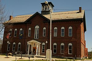
Caledonia Superior Court in St. Johnsbury
|
|

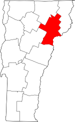
Location within the U.S. state of Vermont
|
|
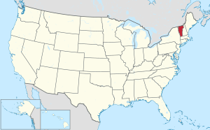
 Vermont's location within the U.S. |
|
| Country | |
| State | |
| Founded | 1796 |
| Named for | Latin name for Scotland |
| Shire Town | St. Johnsbury |
| Largest town | St. Johnsbury |
| Area | |
| • Total | 658 sq mi (1,700 km2) |
| • Land | 649 sq mi (1,680 km2) |
| • Water | 8.7 sq mi (23 km2) 1.3%% |
| Population
(2020)
|
|
| • Total | 30,233 |
| • Density | 45.95/sq mi (17.740/km2) |
| Demonym(s) | Caledonian |
| Time zone | UTC−5 (Eastern) |
| • Summer (DST) | UTC−4 (EDT) |
| Congressional district | At-large |
Caledonia County is a county located in the northeastern part of Vermont, a state in the United States. In 2020, about 30,233 people lived here. The main town, or county seat, is St. Johnsbury. The county was officially created in 1796. It got its name from the Latin word for Scotland, honoring the many early settlers who came from there.
Contents
History
Early Days and Naming
Caledonia County shares its early history with the rest of the Northeast Kingdom region. Long ago, in 1759, a group of soldiers called Rogers' Rangers had to escape through this area. They were being chased and split up to confuse their pursuers. One group traveled south through the Passumpsic River Valley.
Vermont was first divided into two counties in 1778. Later, in 1781, the northern part became Orange County. Then, on November 5, 1792, the state government divided Orange County and another county into six new counties, and Caledonia was one of them. It is believed that the name "Caledonia" was chosen because many Scottish settlers made their homes here.
Important Events
During the American Civil War, many people from Caledonia County joined the Union Army. In September 1861, they became part of the 6th Vermont Infantry regiment, which was part of the First Vermont Brigade.
More recently, in 2008, the county faced severe storms and flooding on July 18. Because of the damage, the area was declared a federal disaster area, which means it could get special help from the government.
Geography
Land and Water
Caledonia County covers a total area of about 658 square miles. Most of this, about 649 square miles, is land, and a small part, about 8.7 square miles, is water.
Even though it's the smallest of the three counties in the Northeast Kingdom area, Caledonia County has the most people living in it.
The county has many rivers and brooks. The Connecticut River flows along its southeastern edge. The northern towns are drained by the Passumpsic River, which is the biggest river in the county. It flows south and joins the Connecticut River. Other rivers include the Wells, Stevens, and Joe's Rivers in the south, and parts of the Winooski and Lamoille Rivers in the west.
There are also about twenty lakes and ponds. Some of the largest are Harvey's Lake, Wells River Pond, Cole's Pond, and Stile's Pond. Some rivers have waterfalls, like the Stevens River, which drops 80 feet in a short distance. People have used the power of these rivers to create electricity.
Underground Features
The ground in much of Caledonia County is made of a type of rock called mica schist. There are also areas with slate rock, which was once quarried for roofing.
In the town of Ryegate, there is a large area of granite rock on Blue Mountain. This granite was formed by volcanoes and was very popular for building in the 1800s. Many monuments across the country, including a soldiers' monument in Peacham, Vermont, were made from this high-quality granite.
The county also has interesting landforms called Kame terraces. These are flat areas of sand and clay left behind by ancient glaciers. Bricks were once made from these deposits. Scientists have studied these terraces, especially in the Passumpsic River Valley, to understand how the land was shaped long ago by water and ice.
Caledonia County also has more "muck" deposits than any other county in Vermont. Muck is a type of soil rich in decayed plant matter.
Neighboring Counties
Caledonia County shares its borders with several other counties:
- Orleans County to the north
- Essex County to the northeast
- Grafton County, New Hampshire to the southeast
- Washington County to the southwest
- Orange County to the south
- Lamoille County to the west
Demographics
| Historical population | |||
|---|---|---|---|
| Census | Pop. | %± | |
| 1800 | 9,377 | — | |
| 1810 | 18,740 | 99.9% | |
| 1820 | 16,669 | −11.1% | |
| 1830 | 20,967 | 25.8% | |
| 1840 | 21,891 | 4.4% | |
| 1850 | 23,595 | 7.8% | |
| 1860 | 21,708 | −8.0% | |
| 1870 | 22,235 | 2.4% | |
| 1880 | 23,607 | 6.2% | |
| 1890 | 23,436 | −0.7% | |
| 1900 | 24,381 | 4.0% | |
| 1910 | 26,031 | 6.8% | |
| 1920 | 25,762 | −1.0% | |
| 1930 | 27,253 | 5.8% | |
| 1940 | 24,320 | −10.8% | |
| 1950 | 24,049 | −1.1% | |
| 1960 | 22,786 | −5.3% | |
| 1970 | 22,789 | 0.0% | |
| 1980 | 25,808 | 13.2% | |
| 1990 | 27,846 | 7.9% | |
| 2000 | 29,702 | 6.7% | |
| 2010 | 31,227 | 5.1% | |
| 2020 | 30,233 | −3.2% | |
| U.S. Decennial Census 1790–1960 1900–1990 1990–2000 2010–2018 |
|||
Population in 2010
According to the 2010 United States Census, there were 31,227 people living in Caledonia County. There were 12,553 households, and 8,153 families. The population density was about 48 people per square mile.
About 29.4% of households had children under 18 living with them. Nearly half, 49.7%, were married couples. The average household had 2.38 people, and the average family had 2.86 people. The average age of people in the county was 42.1 years.
Transportation
Airport
The Caledonia County Airport is located in Lyndon, Vermont, making air travel possible for residents and visitors.
Main Roads
Several important highways run through Caledonia County, connecting its towns and providing routes to other parts of Vermont and beyond:
 Interstate 91
 Interstate 93
 U.S. Route 2
 U.S. Route 5
 U.S. Route 302
Communities
Towns
Villages
Some towns have smaller communities called villages. These villages are still part of their larger towns but might offer extra services.
- Burke Hollow – unincorporated village of Burke
- East Hardwick – unincorporated village of Hardwick
- East Lyndon – unincorporated village of Lyndon
- East Ryegate – unincorporated village of Ryegate
- East St. Johnsbury – unincorporated village of St. Johnsbury
- Lower Waterford – unincorporated village of Waterford
- Lyndon Corner – unincorporated village of Lyndon; corresponds to the Lyndon census-designated place
- Lyndonville – incorporated village of Lyndon
- Mackville – unincorporated village of Hardwick
- McIndoe Falls – unincorporated village of Barnet
- Passumpsic – unincorporated village of Barnet
- Ryegate Corner – unincorporated village of Ryegate
- South Kirby – unincorporated village of Kirby
- South Ryegate – unincorporated village of Ryegate
- St. Johnsbury Center – unincorporated village of St. Johnsbury
- Upper Waterford – unincorporated village of Waterford
- West Burke – incorporated village of Burke
Census-designated places
These are areas identified by the census for statistical purposes.
- Barnet
- Danville
- East Burke
- Groton
- Hardwick
- Lyndon
- Lyndon Center
- Peacham
- Sheffield
- St. Johnsbury
- Sutton
Notable people
- Anne Morrow Lindbergh, a famous writer and aviator, passed away in Passumpsic in 2001.
See also
 In Spanish: Condado de Caledonia para niños
 | Emma Amos |
 | Edward Mitchell Bannister |
 | Larry D. Alexander |
 | Ernie Barnes |

