Walden, Vermont facts for kids
Quick facts for kids
Walden, Vermont
|
|
|---|---|

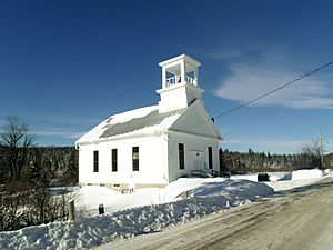
Walden United Methodist Church
|
|

Walden, Vermont
|
|
| Country | United States |
| State | Vermont |
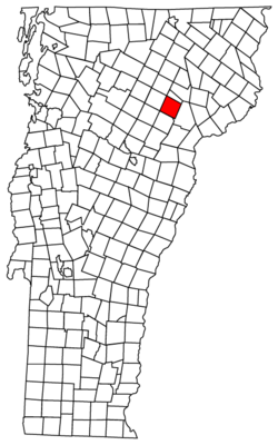
| County | Caledonia |
| Communities | Walden Dows Crossing South Walden Walden Heights |
| Area | |
| • Total | 39.0 sq mi (100.9 km2) |
| • Land | 38.6 sq mi (99.9 km2) |
| • Water | 0.3 sq mi (0.9 km2) |
| Elevation | 1,683 ft (513 m) |
| Population
(2020)
|
|
| • Total | 956 |
| • Density | 25/sq mi (9.6/km2) |
| Time zone | UTC-5 (Eastern (EST)) |
| • Summer (DST) | UTC-4 (EDT) |
| ZIP codes | |
| Area code(s) | 802 |
| FIPS code | 50-75700 |
| GNIS feature ID | 1462238 |
Walden is a small town located in Caledonia County, Vermont, in the United States. In 2020, about 956 people lived there. Even though it's a town, Walden doesn't have its own ZIP code. Mail for Walden is sent through nearby post offices in West Danville and East Hardwick.
Contents
About Walden, Vermont
Walden is a town in the northeastern part of Vermont. It covers an area of about 39.0 square miles (100.9 km2). Most of this area is land, with a small part being water.
Roads and Mountains
Vermont Route 15 is a main road that goes through Walden. This road connects Walden to other towns like Hardwick and Morrisville to the west. It also leads east to Danville. If you travel about 17 miles (27 km) east on Route 15 and U.S. Route 2, you can reach St. Johnsbury, Vermont.
The highest point in Walden is a place called Stannard Mountain. It's located near the northern edge of the town. The top of Stannard Mountain is very high, more than 2,579 feet (786 m) above sea level.
People of Walden
The number of people living in Walden has changed a lot over the years. Back in 1790, only 11 people lived there! The population grew steadily for many years, reaching over 1,000 people in the 1860s. After that, it slowly decreased for a while before starting to grow again in the 1970s.
| Historical population | |||
|---|---|---|---|
| Census | Pop. | %± | |
| 1790 | 11 | — | |
| 1800 | 153 | 1,290.9% | |
| 1810 | 455 | 197.4% | |
| 1820 | 580 | 27.5% | |
| 1830 | 827 | 42.6% | |
| 1840 | 913 | 10.4% | |
| 1850 | 910 | −0.3% | |
| 1860 | 1,099 | 20.8% | |
| 1870 | 992 | −9.7% | |
| 1880 | 931 | −6.1% | |
| 1890 | 810 | −13.0% | |
| 1900 | 764 | −5.7% | |
| 1910 | 739 | −3.3% | |
| 1920 | 674 | −8.8% | |
| 1930 | 664 | −1.5% | |
| 1940 | 547 | −17.6% | |
| 1950 | 481 | −12.1% | |
| 1960 | 427 | −11.2% | |
| 1970 | 442 | 3.5% | |
| 1980 | 575 | 30.1% | |
| 1990 | 703 | 22.3% | |
| 2000 | 782 | 11.2% | |
| 2010 | 935 | 19.6% | |
| 2020 | 956 | 2.2% | |
| U.S. Decennial Census | |||
According to the census from 2000, there were 782 people living in Walden. These people made up 301 households, and 219 of those were families. Most people living in Walden were White. A very small number of people were from other racial backgrounds.
Many households in Walden had children under 18 living with them. The average household had about 2.6 people. The average family had about 3 people. The median age of people in Walden was 36 years old. This means half the people were younger than 36, and half were older.
Famous People from Walden
Walden has been home to several notable people who achieved important things.
- Charles J. Bell (1845–1909): He was the governor of Vermont from 1904 to 1906. A governor is the leader of a state.
- Carrie Breck (1855–1934): She was a poet and wrote many hymns, which are religious songs.
- John L. Edwards (1819–1895): He was a lawyer and a politician. He ran for governor of Vermont in 1867 and 1868.
- George P. Foster (1835–1879): He was a general in the Union Army during the Civil War. He also served as a U.S. Marshal for Vermont.
- Luther Gulick (1892–1993): He was a social scientist, meaning he studied how societies work.
- Judith Jones (1924–2017): She was a famous author and editor. She helped publish important books like The Diary of Anne Frank.
- Josiah O. Livingston (1837–1917): He was a soldier in the Civil War and received the Medal of Honor, which is the highest military award for bravery.
- Frank Livingston Underwood (1844–1918): He was a successful banker and was involved in the copper industry and building railroads.
- Philip Zuchman (1942–2021): He was an artist.
See also
 In Spanish: Walden (Vermont) para niños
 | Percy Lavon Julian |
 | Katherine Johnson |
 | George Washington Carver |
 | Annie Easley |


