
St. Johnsbury, Vermont facts for kids
Quick facts for kids
St. Johnsbury, Vermont
|
|
|---|---|

St. Johnsbury Welcome sign
|
|
| Nickname(s):
St. J
|
|
| Motto(s):
Very Vermont
|
|

St. Johnsbury, Vermont
|
|

St. Johnsbury, Vermont
Location in the United States
|
|
| Country | United States |
| State | Vermont |
| County | Caledonia |
| Chartered | 1786 |
| Settled | 1786 |
| Organized | 1790 |
| Communities | St. Johnsbury St. Johnsbury Center East St. Johnsbury |
| Area | |
| • Total | 36.8 sq mi (95.2 km2) |
| • Land | 36.4 sq mi (94.3 km2) |
| • Water | 0.3 sq mi (0.9 km2) |
| Elevation | 614 ft (187 m) |
| Population
(2020)
|
|
| • Total | 7,364 |
| • Density | 200.34/sq mi (77.35/km2) |
| Time zone | UTC−5 (Eastern (EST)) |
| • Summer (DST) | UTC−4 (EDT) |
| ZIP Codes |
05819 (St. Johnsbury)
05838 (East St. Johnsbury) 05863 (St. Johnsbury Center) 05824 (Concord) 05851 (Lyndonville) |
| Area code(s) | 802 |
| FIPS code | 50-62200 |
| GNIS feature ID | 1462199 |
St. Johnsbury, often called "St. J," is a town in Vermont, USA. It's the main town for Caledonia County. In 2020, about 7,364 people lived there.
St. Johnsbury is located by the Passumpsic River. It's about six miles northwest of the Connecticut River. The town is also about 48 miles south of the Canadian border.
St. Johnsbury is the biggest town in the Northeast Kingdom area of Vermont. It has been an important business center for a long time. Most of the people live in the southern part of town. This area is called the St. Johnsbury census-designated place.
Contents
History of St. Johnsbury


The town was first given land in 1760. It was part of the New Hampshire Grants and called Bessborough. Vermont regranted the land in 1786, naming it Dunmore. People started settling there that same year.
One of the first settlers was Jonathan Arnold. He was a member of the Continental Congress. He also wrote Rhode Island's act to leave the Kingdom of Great Britain in 1776. Arnold moved from Rhode Island in 1787. He and six other families built homes in what is now the town center.
By 1790, the village had 143 people. The first town meeting happened in Arnold's home that year. They decided to name the town St. Johnsbury.
Local stories say that Ethan Allen, a founder of Vermont, suggested the name St. John. This was to honor his friend Jean de Crèvecœur. He was a French writer and farmer, and a friend of Benjamin Franklin. De Crèvecœur supposedly suggested adding "sbury" to make it "St. Johnsbury." This would help tell it apart from Saint John, New Brunswick.
Growth and Industry
In the mid-1800s, St. Johnsbury became a small manufacturing hub. The main products were scales. Thaddeus Fairbanks invented the platform scale there in 1830. They also made maple syrup and related products.
When the railroad line from Boston to Montreal arrived in the 1850s, St. Johnsbury grew fast. It became the county seat in 1856, taking over from Danville. The oldest house still lived in was built in 1798. It's on the corner of Summer and Central streets.

The old St. Johnsbury Fairground was where Interstates 91 and 93 meet today. The Third Vermont Regiment trained there before joining the Union Army in the Civil War. The first airplane flight in Vermont happened at the fair on April 19, 1910.
In the 1940s, the town had three big industrial companies. Each was the largest of its kind in the world. One was Fairbanks Scales. Another made maple sugar candy. The third made candlepins for bowling. Most of the other businesses were related to farming.
Geography of St. Johnsbury
St. Johnsbury is located at 44°25′N 72°01′W / 44.417°N 72.017°W. Its elevation is about 697 feet (212.4 meters). The town covers about 36.7 square miles (95.2 square kilometers). Most of this is land, with a small amount of water.
The town is where the Passumpsic, Moose, and Sleeper's rivers meet. This area is part of the Passumpsic River basin. This basin is one of the largest in the upper Connecticut River watershed. St. Johnsbury is also where the northern edge of Lake Hitchcock used to be. This was a large lake that existed after the glaciers melted, before the Connecticut River formed.
The town includes several small villages. These are St. Johnsbury, East St. Johnsbury, Goss Hollow, and St. Johnsbury Center. The main town center is called a census-designated place (CDP). It includes the villages of St. Johnsbury and St. Johnsbury Center. This CDP covers about 13.1 square miles (33.9 square kilometers).
The highest point in St. Johnsbury is an unnamed hill. It's in the northwestern part of town, east of Libby Road. Its two tops are both over 1,594 feet (486 meters) above sea level.
Climate in St. Johnsbury
| Climate data for St. Johnsbury, Vermont | |||||||||||||
|---|---|---|---|---|---|---|---|---|---|---|---|---|---|
| Month | Jan | Feb | Mar | Apr | May | Jun | Jul | Aug | Sep | Oct | Nov | Dec | Year |
| Record high °F (°C) | 63 (17) |
62 (17) |
84 (29) |
92 (33) |
94 (34) |
98 (37) |
99 (37) |
98 (37) |
95 (35) |
89 (32) |
77 (25) |
67 (19) |
99 (37) |
| Mean daily maximum °F (°C) | 27.6 (−2.4) |
32.0 (0.0) |
42.4 (5.8) |
55.9 (13.3) |
69.9 (21.1) |
77.1 (25.1) |
80.8 (27.1) |
78.2 (25.7) |
69.3 (20.7) |
57.6 (14.2) |
43.4 (6.3) |
31.5 (−0.3) |
55.5 (13.1) |
| Mean daily minimum °F (°C) | 6.4 (−14.2) |
8.3 (−13.2) |
19.6 (−6.9) |
31.1 (−0.5) |
42.7 (5.9) |
52.1 (11.2) |
56.8 (13.8) |
55.4 (13.0) |
47.4 (8.6) |
36.4 (2.4) |
27.6 (−2.4) |
13.7 (−10.2) |
33.1 (0.6) |
| Record low °F (°C) | −35 (−37) |
−43 (−42) |
−27 (−33) |
−2 (−19) |
20 (−7) |
30 (−1) |
36 (2) |
33 (1) |
22 (−6) |
13 (−11) |
−13 (−25) |
−42 (−41) |
−43 (−42) |
| Average precipitation inches (mm) | 2.88 (73) |
2.04 (52) |
2.57 (65) |
2.74 (70) |
3.35 (85) |
3.88 (99) |
3.84 (98) |
4.21 (107) |
3.47 (88) |
3.24 (82) |
3.32 (84) |
3.00 (76) |
38.54 (979) |
| Average snowfall inches (cm) | 22.7 (58) |
16.8 (43) |
15.1 (38) |
5.3 (13) |
0.2 (0.51) |
0 (0) |
0 (0) |
0 (0) |
0.1 (0.25) |
0.6 (1.5) |
6.6 (17) |
20.8 (53) |
88.2 (224.26) |
| Source: NOAA | |||||||||||||
People in St. Johnsbury

| Historical population | |||
|---|---|---|---|
| Census | Pop. | %± | |
| 1790 | 143 | — | |
| 1800 | 663 | 363.6% | |
| 1810 | 1,334 | 101.2% | |
| 1820 | 1,404 | 5.2% | |
| 1830 | 1,592 | 13.4% | |
| 1840 | 1,887 | 18.5% | |
| 1850 | 2,758 | 46.2% | |
| 1860 | 3,469 | 25.8% | |
| 1870 | 4,665 | 34.5% | |
| 1880 | 5,800 | 24.3% | |
| 1890 | 6,567 | 13.2% | |
| 1900 | 7,010 | 6.7% | |
| 1910 | 8,098 | 15.5% | |
| 1920 | 8,708 | 7.5% | |
| 1930 | 9,696 | 11.3% | |
| 1940 | 9,095 | −6.2% | |
| 1950 | 9,292 | 2.2% | |
| 1960 | 8,869 | −4.6% | |
| 1970 | 8,409 | −5.2% | |
| 1980 | 7,938 | −5.6% | |
| 1990 | 7,608 | −4.2% | |
| 2000 | 7,571 | −0.5% | |
| 2010 | 7,604 | 0.4% | |
| 2020 | 7,364 | −3.2% | |
| U.S. Decennial Census | |||
In 2010, there were 7,604 people living in St. Johnsbury. There were 3,236 households and 1,917 families. The town had about 209 people per square mile.
Most people in St. Johnsbury are White (94.5%). Other groups include African American (0.8%), Native American (0.7%), and Asian (1.2%). About 1.5% of the population was Hispanic or Latino.
About 28.8% of households had children under 18. About 44.5% were married couples. The average household had 2.25 people. The average family had 2.85 people.
The median age in town was 39.5 years. For every 100 females, there were about 93.7 males.
The median income for a household was $20,269. For a family, it was $41,961. The income per person was $16,807. About 14.7% of the population lived below the poverty line. This included 37.8% of those under 18.
St. Johnsbury Town Center

The U.S. Census Bureau calls the most developed part of town a census-designated place (CDP).
In 2000, 6,319 people lived in the CDP. There were 2,726 households and 1,561 families. The population density was about 486.8 people per square mile.
Most people in the CDP were White (96.23%). About 1.35% were Hispanic or Latino.
About 27.6% of households in the CDP had children under 18. About 41.6% were married couples. The average household size was 2.18 people.
The median age in the CDP was 40 years. For every 100 females, there were 93.0 males.
The median income for a household in the CDP was $26,702. For a family, it was $39,890. About 15.8% of the population was below the poverty line.
Education in St. Johnsbury

- St. Johnsbury Academy is a private high school. The Fairbanks family, including Erastus Fairbanks, started it in 1842. St. Johnsbury does not have its own public high school. However, Vermont law requires towns to pay tuition for students to attend approved schools. Most high school students from St. Johnsbury go to St. Johnsbury Academy, and the town pays for it.
- St. Johnsbury Trade School opened in 1918. It offered the only four-year vocational education in the area. The founders, Fairbanks, Morse and Company, wanted young people to learn a trade. This would help them earn more money. After over 50 years, the Trade School closed. The building then became the junior high. In 1981, it became the St. Johnsbury Middle School. After combining local schools, the old trade school building became the St. Johnsbury School. It now serves students from kindergarten to 8th grade.
- St. Johnsbury School now teaches students from pre-kindergarten to 8th grade.
- Good Shepherd School is run by St. John the Evangelist Roman Catholic Church. It teaches students from pre-school to 8th grade.
Economy of St. Johnsbury
Industry in St. Johnsbury

- E.T. & H.K. Ide Company was a grain wholesaler. It started in 1813 and was the oldest continuous business in town. The family stopped operations in 2003.
- Fairbanks Scales is a company that makes precision machinery. It has been in business for over 190 years. It still employs 160 workers.
- Maple Grove Farms of Vermont was started by Katharine Ide Gray in 1915. It is the largest company that packages pure maple syrup in the United States. In 2006, they had 100 employees and sales of $75 million. They are now part of B&G Foods.
Shopping in St. Johnsbury
Green Mountain Mall is a shopping center north of downtown St. Johnsbury. It is located on U.S. Route 5. The main store used to be JCPenney. However, JCPenney closed this store in May 2021.
Healthcare in St. Johnsbury
The Northeast Kingdom Human Services helps with mental health needs. The Northeastern Vermont Regional Hospital is also located in the town.
Culture in St. Johnsbury

St. Johnsbury is home to the Fairbanks Museum & Planetarium. Franklin Fairbanks, a businessman and nature lover, gave it to the community in 1891. His collections are the largest natural history display in northern New England. The building itself is a beautiful example of Richardsonian Romanesque style architecture. The Fairbanks Museum is also known for its "Eye on the Sky" weather forecast. This forecast is heard on Vermont Public Radio and Magic 97.7 FM.
Since 1993, the town has had an annual First Night celebration. This event celebrates the arts on New Year's Eve.
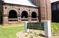
The town has the only National Historic Landmark in Caledonia County and the Northeast Kingdom. This is the St. Johnsbury Athenaeum. The town also has 13 other places listed on the National Register of Historic Places. These include:
- Benoit Apartment House – 74 Pearl Street (added 1994)
- Benoit Apartment House – 76 Pearl Street (added 1994)
- Caleb H. Marshall House — 53 Summer St. (added 1994)
- Cote Apartment House — 16 Elm St. (added 1994)
- Franklin Fairbanks House — 30 Western Ave. (added 1980)
- Fairbanks Museum & Planetarium – 1302 Main St. (added 2007)
- Maple Street-Clarks Avenue Historic District (added 1994)
- Morency Paint Shop and Apartment Building — 73-77 Portland St. (added 1994)
- Railroad Street Historic District (added 1974)

- Shearer and Corser Double House — 81-83 Summer St. (added 1994)
- St. Johnsbury Federal Fish Culture Station — 374 Emerson Falls Rd. (added 2005)
- St. Johnsbury Historic District — U.S. 5 and U.S. 2 (added 1980)
- St. Johnsbury Main Street Historic District (added 1975)
The town is mentioned in Hayden Carruth's famous poem "Regarding Chainsaws." Carruth lived and farmed in this part of Vermont for many years.
Media in St. Johnsbury
The Caledonian-Record is a daily newspaper. It has been published in St. Johnsbury since 1837. Farming, the Journal of Northeast Agriculture is also published locally.
Transportation in St. Johnsbury
Several important roads pass through St. Johnsbury. These include Interstate 91, Interstate 93, U.S. Route 2, and U.S. Route 5. There are three exits from Interstate 91 that serve the town. The northern end of Interstate 93 connects to I-91 at the southern edge of town. I-93 Exit 1, which is just in the town of Waterford, also serves the east side of St. Johnsbury.
Notable People from St. Johnsbury
Images for kids
-
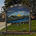
St. Johnsbury Welcome sign
-
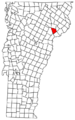
St. Johnsbury, Vermont
-
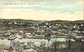
Bird's-eye view around 1910
-
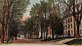
South Main Street around 1905
-
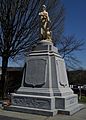
This monument in Courthouse Park honors Civil War volunteers.
-
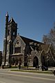
North Congregational Church on Main Street
-
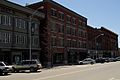
Railroad Street in downtown St. Johnsbury
-
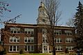
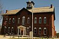
St. Johnsbury Academy – Colby Hall
-
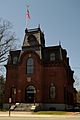
Caledonia Superior Court on Main Street
-
The St. Johnsbury Athenaeum is the only National Historic Landmark in the Northeast Kingdom.
-
Fairbanks Museum
See also
 In Spanish: St. Johnsbury para niños
