Stannard, Vermont facts for kids
Quick facts for kids
Stannard, Vermont
|
|
|---|---|
 |
|

Stannard, Vermont
|
|
| Country | |
| State | |
| County | Caledonia |
| Area | |
| • Total | 12.5 sq mi (32.4 km2) |
| • Land | 12.4 sq mi (32.2 km2) |
| • Water | 0.08 sq mi (0.2 km2) |
| Elevation | 1,729 ft (527 m) |
| Population
(2020)
|
|
| • Total | 208 |
| • Density | 17/sq mi (6.5/km2) |
| Time zone | UTC-5 (Eastern (EST)) |
| • Summer (DST) | UTC-4 (EDT) |
| ZIP Codes |
05842 (Greensboro Bend)
05836 (East Hardwick) |
| Area code(s) | 802 |
| FIPS code | 50-69925 |
| GNIS feature ID | 1462216 |
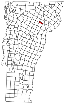
Stannard is a small town in Caledonia County, Vermont, in the United States. In 2020, about 208 people lived there. It is known for not having any paved roads.
History of Stannard
Stannard was once called Goshen Gore No. 1. It was renamed Stannard to honor General George J. Stannard. He was a hero during the American Civil War. General Stannard and his soldiers helped stop a major attack called Pickett's Charge. They also fought back troops from Florida and Alabama. In 1865, the state of Vermont praised him for his "skill and bravery."
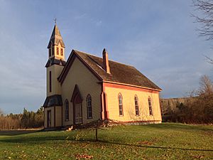
In the center of Stannard, you can find the old Methodist Church. There is also the Stannard Schoolhouse. This building used to be a school. Now, it is where the town government meets.
People from Stannard
Many interesting people have connections to Stannard.
- Andrew M. Blair was born and grew up in Stannard. He later became a member of the Wisconsin Senate.
- Charles Clark Jamieson was a brigadier general in the U.S. Army. He was raised in Stannard.
- Bernie Sanders, a well-known U.S. Senator, lived in Stannard for several years. He was there from the late 1960s to the early 1970s.
Geography and Nature
Stannard covers about 32.4 square kilometers (12.5 square miles). Most of this area is land, with a small part being water.
The highest point in the town is Stannard Mountain. This mountain rises about 798 meters (2,618 feet) above sea level. Most of the town's land slopes towards the west. Water from this area flows into the Lamoille River. This river eventually reaches Lake Champlain. The eastern part of Stannard drains into the Connecticut River.
Population Changes
| Historical population | |||
|---|---|---|---|
| Census | Pop. | %± | |
| 1850 | 215 | — | |
| 1860 | 240 | 11.6% | |
| 1870 | 228 | −5.0% | |
| 1880 | 252 | 10.5% | |
| 1890 | 239 | −5.2% | |
| 1900 | 222 | −7.1% | |
| 1910 | 206 | −7.2% | |
| 1920 | 173 | −16.0% | |
| 1930 | 154 | −11.0% | |
| 1940 | 140 | −9.1% | |
| 1950 | 116 | −17.1% | |
| 1960 | 113 | −2.6% | |
| 1970 | 88 | −22.1% | |
| 1980 | 142 | 61.4% | |
| 1990 | 148 | 4.2% | |
| 2000 | 185 | 25.0% | |
| 2010 | 216 | 16.8% | |
| 2020 | 208 | −3.7% | |
| U.S. Decennial Census | |||
The population of Stannard has changed over many years. In 2000, there were 185 people living in the town. The town had 73 households and 54 families. About 37% of the households had children under 18. The average household had about 2.5 people.
The median age in Stannard in 2000 was 38 years old. About 28% of the population was under 18. Around 10.8% of the people were 65 or older.
The median income for a household in 2000 was $36,250. This means half of the households earned more and half earned less. About 18.8% of the people in Stannard lived below the poverty line.
See also
 In Spanish: Stannard (Vermont) para niños
 | Jackie Robinson |
 | Jack Johnson |
 | Althea Gibson |
 | Arthur Ashe |
 | Muhammad Ali |


