Groton, Vermont facts for kids
Quick facts for kids
Groton, Vermont
|
|
|---|---|
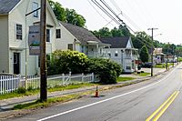
Houses along Scott Highway
|
|
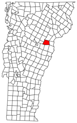
Groton, Vermont
|
|
| Country | United States |
| State | Vermont |
| County | Caledonia |
| Communities | Groton Ricker Mills West Groton |
| Area | |
| • Total | 55.0 sq mi (142.4 km2) |
| • Land | 53.7 sq mi (139.2 km2) |
| • Water | 1.2 sq mi (3.1 km2) |
| Elevation | 1,106 ft (337 m) |
| Population
(2020)
|
|
| • Total | 984 |
| • Density | 18/sq mi (7.1/km2) |
| Time zone | UTC-5 (Eastern (EST)) |
| • Summer (DST) | UTC-4 (EDT) |
| ZIP code |
05046
|
| Area code(s) | 802 |
| FIPS code | 50-30550 |
| GNIS feature ID | 1462110 |
Groton is a small town located in Caledonia County, Vermont, in the United States. In 2020, about 984 people lived there. Groton is home to several smaller communities like Groton Pond, Rickers Mills, Rickers, and West Groton. The main village of Groton, located in the southeast, had a population of 419 in 2020.
Contents
History of Groton
The town of Groton has an interesting past. People aren't entirely sure how it got its name. Some believe it was named after another town called Groton, Massachusetts. Others think it might have been named after Groton, Connecticut.
Geography and Nature
Groton is found in the southwestern part of Caledonia County. It shares borders with several other towns. To the north is Peacham, to the northeast is Barnet, and to the east is Ryegate. All these towns are also in Caledonia County.
South of Groton, in Orange County, you'll find Newbury, Topsham, and Orange. To the west, in Washington County, are Plainfield and Marshfield.
The town covers a total area of about 142.4 square kilometers (55 square miles). Most of this area, about 139.2 square kilometers (53.7 square miles), is land. The rest, about 3.1 square kilometers (1.2 square miles), is water.
The Wells River, which flows into the Connecticut River, starts right here in Groton. A large part of the western side of town is covered by Groton State Forest. The highest point in Groton is Signal Mountain, which stands at about 3,352 feet (1,022 meters) tall.
The main village of Groton is in the southeastern corner of the town. It's located along US Route 302 and the Wells River. This village covers about 5.36 square kilometers (2.07 square miles).
Population and People
| Historical population | |||
|---|---|---|---|
| Census | Pop. | %± | |
| 1790 | 45 | — | |
| 1800 | 248 | 451.1% | |
| 1810 | 449 | 81.0% | |
| 1820 | 595 | 32.5% | |
| 1830 | 836 | 40.5% | |
| 1840 | 928 | 11.0% | |
| 1850 | 895 | −3.6% | |
| 1860 | 939 | 4.9% | |
| 1870 | 811 | −13.6% | |
| 1880 | 1,014 | 25.0% | |
| 1890 | 1,040 | 2.6% | |
| 1900 | 1,059 | 1.8% | |
| 1910 | 915 | −13.6% | |
| 1920 | 902 | −1.4% | |
| 1930 | 803 | −11.0% | |
| 1940 | 764 | −4.9% | |
| 1950 | 712 | −6.8% | |
| 1960 | 631 | −11.4% | |
| 1970 | 666 | 5.5% | |
| 1980 | 667 | 0.2% | |
| 1990 | 862 | 29.2% | |
| 2000 | 876 | 1.6% | |
| 2010 | 1,022 | 16.7% | |
| 2020 | 984 | −3.7% | |
| U.S. Decennial Census | |||
In the year 2000, there were 876 people living in Groton. These people lived in 338 homes, and 252 of those were families. The town had about 16 people per square mile.
Most of the people in Groton were White (96.46%). A small number were Native American (1.26%) or from two or more races (2.05%). About 0.34% of the population was Hispanic or Latino.
Many homes (35.8%) had children under 18 living there. About 61.8% of homes were couples living together. The average household had about 2.59 people.
The population was spread out by age. About 28.3% were under 18. About 25.8% were between 25 and 44 years old. And 14.6% were 65 years or older. The average age in Groton was 39 years old.
Roads and Transportation
Groton has important roads that help people travel.
 U.S. Route 302 goes through the southern part of town. This road leads east to places like Wells River, Vermont and Woodsville, New Hampshire. It also goes west to Barre and Montpelier.
 Vermont Route 232 starts from US-302. It goes north through Groton State Forest all the way to Marshfield.
Fun and Recreation
Groton is a great place for outdoor fun! It has five state parks located within Groton State Forest. These parks are:
- Big Deer State Park
- Boulder Beach State Park
- Ricker Pond State Park
- Seyon Lodge State Park
- Stillwater State Park
You can also visit the Groton Nature Center. In these parks, you can enjoy many activities. These include hiking, camping, fishing, swimming, boating, and picnicking. In winter, you can go snowshoeing and cross-country skiing.
Groton also has special events each year. These include the Groton Fall Festival and the Fall Foliage Chicken Pie.
Notable People from Groton
Some interesting people have connections to Groton:
- Bristol Bill was a famous burglar and counterfeiter. He lived in Groton and was caught there after a long time of committing crimes.
- William Scott was a soldier in the Civil War. He was pardoned by President Abraham Lincoln. He was known as "The Sleeping Sentinel" and was born in Groton.
See also
 In Spanish: Groton (Vermont) para niños
 | James Van Der Zee |
 | Alma Thomas |
 | Ellis Wilson |
 | Margaret Taylor-Burroughs |


