Lyndon, Vermont facts for kids
Quick facts for kids
Lyndon, Vermont
|
|
|---|---|

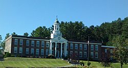
Lyndon Institute in Lyndon Center
|
|

Lyndon, Vermont
|
|
| Country | United States |
| State | Vermont |
| County | Caledonia |
| Communities | Lyndon Center Lyndonville East Lyndon Little Egypt Lyndon Corner |
| Area | |
| • Total | 39.8 sq mi (103.1 km2) |
| • Land | 39.5 sq mi (102.2 km2) |
| • Water | 0.3 sq mi (0.9 km2) |
| Elevation | 700 ft (213 m) |
| Population
(2020)
|
|
| • Total | 5,491 |
| • Density | 137.94/sq mi (53.259/km2) |
| Time zone | UTC-5 (Eastern (EST)) |
| • Summer (DST) | UTC-4 (EDT) |
| ZIP codes | |
| Area code(s) | 802 |
| FIPS code | 50-41725 |
| GNIS feature ID | 1462140 |
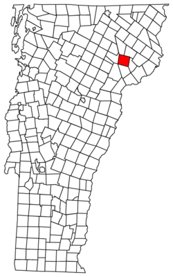
Lyndon is a town in Caledonia County, Vermont, United States. In 2020, about 5,491 people lived there. Lyndon is home to Vermont State University – Lyndon, a college campus.
The town has five small communities. These include Lyndonville, Lyndon Corner, Lyndon Center, Little Egypt, and East Lyndon. Lyndon is the second-largest town in the Northeast Kingdom area of Vermont. Only St. Johnsbury is bigger.
Contents
Lyndon's Early History
When Lyndon was first planned, the area was mostly covered in thick forests. The Passumpsic River flows through the town. This river was important because it powered early mills. These mills helped cut wood and grind grain.
The official document to create the town of Lyndon was signed in 1780. Governor Thomas Chittenden signed this important paper.
How Lyndon Got Its Name
Lyndon was likely named after Josias Lyndon (1704–1778). He was a former governor of Rhode Island. Many of the people who helped get the land for Lyndon knew him. These people were called "proprietors."
The proprietors first got the land as a business idea. They did not plan to live there themselves. Instead, they looked for people who wanted free land. These new settlers would clear the land for the proprietors.
First Settlers and Growth
The town was surveyed in 1781. This means the land was measured and mapped out. People started settling in Lyndon in 1789. By 1790, twelve families lived there, with 59 residents.
These early families worked hard to build the town. They created roads, mills, homes, and farms. They also built churches and schools.
Village Changes Over Time
The village of Lyndon Corner became an official village in 1792. Lyndon Center followed in 1794. Much later, Lyndonville became an official village in 1866.
Lyndon Corner was about 2 miles (3.2 km) south of Lyndonville. A hotel called Hotel Lyndon was built there in 1807. It later became a tavern and burned down in 1897.
Around 1867, a new railroad was built. It went around Lyndon Corner and Lyndon Center. This caused businesses to move to Lyndonville. The older villages became mostly places where people lived. They are no longer separate official villages today.
Important Contributions to Lyndon
In the late 1880s, a local resident named Theodore Newton Vail held meetings in Lyndon. These meetings led to the creation of American Telephone & Telegraph (AT&T). Vail also built Vermont's first paved road in Lyndon. This road went from the train station to his home.
In 1891, people buried an iron box as a time capsule during a celebration. They hoped to find it 100 years later. But in 1991, they could not find the box.
The Lyndon Outing Club used to hold a winter festival. This was in the late 1930s and early 1940s. The festival had exciting events like dog sled races and ski jumping competitions.
Lyndon's Geography
Lyndon is in the northeastern part of Vermont. It sits in the valley of the Passumpsic River. To the south is St. Johnsbury. Other nearby towns include Danville, Wheelock, Sutton, Burke, and Kirby.
The town covers about 39.8 square miles (103.1 km2). Most of this area, about 39.5 square miles (102.2 km2), is land. Only a small part, about 0.3 square miles (0.9 km2), is water.
The highest point in Lyndon is Diamond Hill. It is in the southwest part of town. Its elevation is a little more than 1,640 feet (500 meters) high.
Land Features of Lyndon
Lyndonville, the main village, is partly built on a high landform called a kame terrace. This type of land was formed by glaciers. The lower layers of this land are made of clay.
West of this terrace, the land is lower. There is also an old river bed that once flowed towards the east. Near the upper village of Lyndon, there is another wide terrace. It has a lot of sand and fine gravel.
Every stream in the valley has its own terraces. These terraces are usually large but few in number. It is rare to find more than five of them.
Lyndon's Population
| Historical population | |||
|---|---|---|---|
| Census | Pop. | %± | |
| 1790 | 59 | — | |
| 1800 | 542 | 818.6% | |
| 1810 | 1,090 | 101.1% | |
| 1820 | 1,296 | 18.9% | |
| 1830 | 1,822 | 40.6% | |
| 1840 | 1,753 | −3.8% | |
| 1850 | 1,752 | −0.1% | |
| 1860 | 1,695 | −3.3% | |
| 1870 | 2,179 | 28.6% | |
| 1880 | 2,434 | 11.7% | |
| 1890 | 2,619 | 7.6% | |
| 1900 | 2,956 | 12.9% | |
| 1910 | 3,204 | 8.4% | |
| 1920 | 3,558 | 11.0% | |
| 1930 | 3,285 | −7.7% | |
| 1940 | 3,144 | −4.3% | |
| 1950 | 3,360 | 6.9% | |
| 1960 | 3,425 | 1.9% | |
| 1970 | 3,705 | 8.2% | |
| 1980 | 4,924 | 32.9% | |
| 1990 | 5,371 | 9.1% | |
| 2000 | 5,448 | 1.4% | |
| 2010 | 5,981 | 9.8% | |
| 2020 | 5,491 | −8.2% | |
| U.S. Decennial Census | |||
In 2000, there were 5,448 people living in Lyndon. There were 2,031 households and 1,326 families. The town had about 137 people per square mile (52.9/km2).
Most of the people living in Lyndon were White (97.76%). A small number were African American, Native American, or Asian.
About 31.6% of households had children under 18. About 50.2% were married couples. The average household had 2.43 people. The average family had 2.94 people.
The population included people of all ages. About 23.1% were under 18. About 17.0% were between 18 and 24. The median age was 35 years old. The college dorms in Lyndon affect the age of the town's population.
Education in Lyndon
Lyndon has several schools for different age groups:
- Lyndon Town School – This is a public elementary school.
- Thaddeus Stevens School – This is a private school. It moved to Lyndon in 2012.
- Lyndon Institute – This is a private high school.
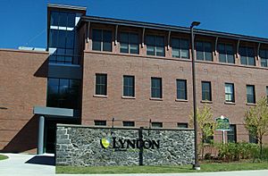
- Vermont State University – Lyndon – This is a college campus. It used to be called Northern Vermont University – Lyndon and Lyndon State College.
Transportation in Lyndon
Two main roads pass through Lyndon from north to south. These are Interstate 91 and U.S. Route 5. Interstate 91 has two exits in town.
Vermont Route 114 also meets U.S. Route 5 in Lyndonville. It then goes northeast from there.
Notable People from Lyndon
- Nicholas Baylies, who was a Justice of the Vermont Supreme Court.
- Elizabeth Rowell Thompson, a person known for giving money to good causes.
- Theodore Newton Vail, a very important person in the telephone industry.
See also
 In Spanish: Lyndon (Vermont) para niños
 | Emma Amos |
 | Edward Mitchell Bannister |
 | Larry D. Alexander |
 | Ernie Barnes |


