Maidstone, Vermont facts for kids
Quick facts for kids
Maidstone, Vermont
|
|
|---|---|
|
Town
|
|

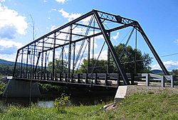
The Janice Peaslee Bridge goes over the Connecticut River and connects Maidstone to Stratford, NH.
|
|

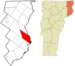
Location in Essex County and the state of Vermont.
|
|

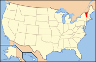
Location of Vermont in the United States
|
|
| Country | United States |
| State | Vermont |
| County | Essex |
| Area | |
| • Total | 32.3 sq mi (83.6 km2) |
| • Land | 30.5 sq mi (79.1 km2) |
| • Water | 1.7 sq mi (4.5 km2) |
| Elevation | 1,243 ft (379 m) |
| Population
(2020)
|
|
| • Total | 211 |
| • Density | 7/sq mi (2.7/km2) |
| Time zone | UTC-5 (EST) |
| • Summer (DST) | UTC-4 (EDT) |
| ZIP code |
05905
|
| Area code(s) | 802 |
| FIPS code | 50-42475 |
| GNIS feature ID | 1462141 |
Maidstone is a small town located in Essex County, Vermont, in the United States. In 2020, about 211 people lived there. It is part of the larger Berlin, New Hampshire – Vermont Micropolitan Statistical Area. Maidstone does not have a busy town center or a gas station. However, it does have a town office building in the southern part of the town.
Contents
History of Maidstone
The town of Maidstone was given its name after a place called Maidstone, which is in England.
Geography of Maidstone
Maidstone is located in the eastern part of Essex County. It sits along the Connecticut River, which forms the border between Vermont and New Hampshire.
Neighboring Towns
Maidstone is surrounded by several other towns. To the south is Guildhall, to the southwest is Granby, and to the northwest is Ferdinand. Brunswick is to the north. All these towns are in Vermont. Across the Connecticut River, in New Hampshire, are Stratford to the northeast and Northumberland to the east.
Rivers and Roads
The only way to cross the Connecticut River from Maidstone is by using the Janice Peaslee Bridge. This bridge is in the northern part of town and leads to Stratford village in New Hampshire. Vermont Route 102 runs along the eastern side of Maidstone, following the Connecticut River valley.
Land and Water Features
According to the United States Census Bureau, Maidstone covers a total area of about 83.6 square kilometers (32.3 square miles). Most of this area, about 79.1 square kilometers (30.5 square miles), is land. The remaining 4.5 square kilometers (1.7 square miles), or about 5.39%, is water.
Maidstone Lake is a large body of water found in the western part of the town. Maidstone State Park is located on the east and south sides of this lake. The park offers many outdoor activities like camping, fishing, swimming, and hiking. The highest point in Maidstone is Stoneham Mountain, which is about 2,143 feet (653 meters) tall and is located east of Maidstone Lake.
Population in Maidstone
In 2000, there were 105 people living in Maidstone, making up 45 households. About 30 of these households were families. The population density was about 3.4 people per square mile (1.3 people per square kilometer).
Population Changes Over Time
The population of Maidstone has changed quite a bit over the years.
- In 1790, there were 125 people.
- By 1850, the population was 237.
- It dropped to 81 people in 1950.
- In 2010, the population grew to 208.
- By 2020, the population was 211 people.
Age and Gender Distribution
In 2000, about 14.3% of the population was under 18 years old. About 41.0% were between 45 and 64 years old. The average age in Maidstone was 46 years. For every 100 females, there were about 133 males.
See also
 In Spanish: Maidstone (Vermont) para niños
 | Claudette Colvin |
 | Myrlie Evers-Williams |
 | Alberta Odell Jones |

