Canaan (CDP), Vermont facts for kids
Quick facts for kids
Canaan, Vermont
|
|
|---|---|

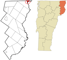
Location in Essex County and the state of Vermont.
|
|
| Country | United States |
| State | Vermont |
| County | Essex |
| Town | Canaan |
| Area | |
| • Total | 1.63 sq mi (4.22 km2) |
| • Land | 1.58 sq mi (4.10 km2) |
| • Water | 0.05 sq mi (0.12 km2) |
| Elevation | 1,043 ft (318 m) |
| Population
(2010)
|
|
| • Total | 392 |
| • Density | 248/sq mi (95.6/km2) |
| Time zone | UTC-5 (Eastern (EST)) |
| • Summer (DST) | UTC-4 (EDT) |
| ZIP code |
05901, 05903
|
| Area code(s) | 802 |
| GNIS feature ID | 1456760 |
| FIPS code | 50-11725 |
Canaan is a small community in Vermont, United States. It's known as a census-designated place, which means it's a special area identified for gathering population information. Canaan is located in Essex County. In 2010, about 392 people lived here. The whole town of Canaan had a population of 972 people at that time.
Contents
Where is Canaan Located?
Canaan is in the very northeast part of the town of Canaan. It's surrounded by natural features and other communities. To the west, you'll find Leach Creek. The Connecticut River flows to its southeast.
Nearby Communities and Borders
The community of Beecher Falls, Vermont is to the east of Canaan. To the north, Canaan borders the country of Canada, specifically the province of Quebec. Across the Connecticut River to the southeast is West Stewartstown, New Hampshire. Beecher Falls is actually the community furthest northeast in all of Vermont!
How Big is Canaan?
The Canaan census-designated place covers a total area of about 4.2 square kilometers (which is about 1.6 square miles). Most of this area is land.
Land and Water Area
About 4.1 square kilometers (1.6 square miles) of Canaan is land. The rest, about 0.12 square kilometers (0.046 square miles), is water. This means that about 2.87% of Canaan's total area is covered by water.
See also
 In Spanish: Canaan (condado de Essex) para niños
 | Sharif Bey |
 | Hale Woodruff |
 | Richmond Barthé |
 | Purvis Young |

