Millsfield, New Hampshire facts for kids
Quick facts for kids
Millsfield, New Hampshire
|
|
|---|---|

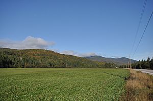
Hills in Dixville from New Hampshire Route 26 in Millsfield
|
|

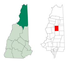
Location in Coös County, New Hampshire
|
|
| Country | United States |
| State | New Hampshire |
| County | Coös |
| Area | |
| • Total | 45.2 sq mi (117.1 km2) |
| • Land | 44.8 sq mi (116.1 km2) |
| • Water | 0.4 sq mi (1.0 km2) 0.89% |
| Elevation | 2,030 ft (620 m) |
| Population
(2020)
|
|
| • Total | 25 |
| • Density | 0.6/sq mi (0.22/km2) |
| Time zone | UTC-5 (Eastern) |
| • Summer (DST) | UTC-4 (Eastern) |
| Area code(s) | 603 |
| FIPS code | 33-007-48260 |
| GNIS feature ID | 873667 |
Millsfield is a small area in Coös County, New Hampshire, United States. It's called a "township" and is part of the Berlin area. In 2020, only 25 people lived there.
In New Hampshire, a "township" is a special kind of area. It's not like a regular town. These townships are parts of a county that don't have their own local government, or only a very small one. Many of them don't have anyone living in them at all.
Contents
History of Millsfield
In 1774, Millsfield was given to a person named George Boyd and some others. It was a large area, about 23,200 acres (94 square kilometers). The place was named after Sir Thomas Mills. Much later, in 1952, Millsfield was set up so that the people living there could vote in elections.
Geography and Nature
Millsfield covers a total area of about 117.1 square kilometers (45.2 square miles). Most of this area, about 116.1 square kilometers (44.8 square miles), is land. The rest, about 1.0 square kilometer (0.4 square miles), is water.
Waterways and Ponds
Right in the middle of Millsfield, you'll find Millsfield Pond. Water from this pond flows northeast into a stream called Clear Stream. Clear Stream then continues eastward and eventually joins the Androscoggin River.
The southeastern part of Millsfield also has water that flows into the Androscoggin River. This happens through Newell Brook and the water coming from Moose Pond. In the southwestern part of the township, Phillips Brook flows south. This brook is part of the Connecticut River system, as it eventually joins the Upper Ammonoosuc River, which then flows into the Connecticut River.
Roads and Mountains
New Hampshire Route 26 is a main road that goes through the northeastern part of Millsfield, following Clear Stream. If you go northwest on this road, you'll cross Dixville Notch and reach Colebrook. If you go southeast, the road leads to Errol and then to the border of Maine.
Millsfield has the only road that leads to Erving's Location, which is another township where no one lives. This road goes north of Mount Kelsey. Mount Kelsey is the highest point in Millsfield, standing at about 3,472 feet (1,058 meters) above sea level.
Nearby Places
Millsfield is surrounded by several other towns and townships:
- Dixville (to the north)
- Wentworth Location (to the northeast)
- Errol (to the east)
- Dummer (to the south)
- Odell (to the west)
- Erving's Location (to the northwest)
Population Changes
Millsfield has always been a very small place. Here's how its population has changed over the years:
| Historical population | |||
|---|---|---|---|
| Census | Pop. | %± | |
| 1830 | 33 | — | |
| 1840 | 12 | −63.6% | |
| 1860 | 15 | — | |
| 1870 | 28 | 86.7% | |
| 1880 | 62 | 121.4% | |
| 1890 | 62 | 0.0% | |
| 1900 | 41 | −33.9% | |
| 1910 | 12 | −70.7% | |
| 1920 | 45 | 275.0% | |
| 1930 | 33 | −26.7% | |
| 1940 | 34 | 3.0% | |
| 1950 | 16 | −52.9% | |
| 1960 | 7 | −56.2% | |
| 1970 | 18 | 157.1% | |
| 1980 | 7 | −61.1% | |
| 1990 | 21 | 200.0% | |
| 2000 | 22 | 4.8% | |
| 2010 | 23 | 4.5% | |
| 2020 | 25 | 8.7% | |
| U.S. Decennial Census | |||
In the year 2000, there were 22 people living in Millsfield. These people lived in 8 different homes, and 5 of those were families. The population was spread out in terms of age. About 13.6% of the people were under 18 years old, and a large portion, 45.5%, were 65 years or older. The average age was 52 years.
See also
 In Spanish: Millsfield (Nuevo Hampshire) para niños
 | Kyle Baker |
 | Joseph Yoakum |
 | Laura Wheeler Waring |
 | Henry Ossawa Tanner |

