Milan, New Hampshire facts for kids
Quick facts for kids
Milan, New Hampshire
|
|
|---|---|
|
Town
|
|

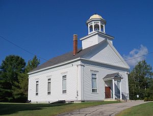
First United Methodist Church in Milan
|
|

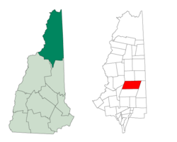
Location in Coos County, New Hampshire
|
|
| Country | United States |
| State | New Hampshire |
| County | Coos |
| Incorporated | 1824 |
| Villages |
|
| Area | |
| • Total | 64.45 sq mi (166.92 km2) |
| • Land | 63.69 sq mi (164.95 km2) |
| • Water | 0.76 sq mi (1.97 km2) 1.18% |
| Elevation | 1,135 ft (346 m) |
| Population
(2020)
|
|
| • Total | 1,358 |
| • Density | 21/sq mi (8.2/km2) |
| Time zone | UTC-5 (Eastern) |
| • Summer (DST) | UTC-4 (Eastern) |
| ZIP code |
03588
|
| Area code(s) | 603 |
| FIPS code | 33-47860 |
| GNIS feature ID | 0873665 |
Milan (pronounced MY-luhn) is a small town in Coös County, New Hampshire, United States. In 2020, about 1,358 people lived there. It is part of the larger Berlin area.
Contents
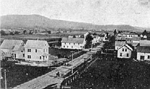
Milan's Early History
Milan was first called "Paulsburg" in 1771. It was named after a person named Paul Wentworth. The town officially became a town on December 16, 1824. That same year, Governor Levi Woodbury changed its name to "Milan."
Before 1820, only a few people lived in Milan. By 1819, there were about 14 residents. Ten years later, this number had grown to about 56 people.
First Industries and Farms
Like other towns nearby, Milan's first main jobs were in lumbering. This means cutting down trees for wood. Farming was not as important at first. The very first farms were built on Milan Hill. The soil there was warmer and had less frost. For a while, these farms grew a lot of crops.
However, these farms did not stay productive for long. Many early settlers moved to lands along the river. These river lands were more fertile and valuable. Some of the first families to settle in Milan included the Ellingwoods, Hodgdons, Foggs, and Hinds.
Geography and Location
Milan covers a total area of about 166.9 square kilometers (64.4 square miles). Most of this area, about 165.0 square kilometers (63.7 square miles), is land. The rest, about 2.0 square kilometers (0.8 square miles), is water. Water makes up about 1.18% of the town's total area.
The highest point in Milan is the top of Deer Ridge. It is about 856 meters (2,808 feet) above sea level.
Neighboring Towns
Milan shares its borders with several other towns:
- Dummer to the north
- Cambridge to the northeast
- Success to the east
- Berlin to the south
- Kilkenny to the west
- Stark to the northwest
Milan's Climate
Milan has a type of weather called a humid continental climate. This means it has warm, humid summers and cold, snowy winters. The Berlin Regional Airport is located in Milan.
| Climate data for Berlin Municipal Airport, New Hampshire, 1991–2020 normals: 1158ft (353m) | |||||||||||||
|---|---|---|---|---|---|---|---|---|---|---|---|---|---|
| Month | Jan | Feb | Mar | Apr | May | Jun | Jul | Aug | Sep | Oct | Nov | Dec | Year |
| Mean daily maximum °F (°C) | 27.0 (−2.8) |
30.2 (−1.0) |
38.9 (3.8) |
52.6 (11.4) |
66.6 (19.2) |
75.1 (23.9) |
79.8 (26.6) |
78.2 (25.7) |
70.9 (21.6) |
57.4 (14.1) |
44.0 (6.7) |
32.2 (0.1) |
54.4 (12.4) |
| Daily mean °F (°C) | 14.8 (−9.6) |
16.6 (−8.6) |
26.5 (−3.1) |
39.8 (4.3) |
51.8 (11.0) |
61.0 (16.1) |
65.8 (18.8) |
64.2 (17.9) |
56.6 (13.7) |
44.7 (7.1) |
33.4 (0.8) |
21.8 (−5.7) |
41.4 (5.2) |
| Mean daily minimum °F (°C) | 2.5 (−16.4) |
3.0 (−16.1) |
14.0 (−10.0) |
27.0 (−2.8) |
37.1 (2.8) |
46.9 (8.3) |
51.8 (11.0) |
50.1 (10.1) |
42.4 (5.8) |
32.0 (0.0) |
22.7 (−5.2) |
11.5 (−11.4) |
28.4 (−2.0) |
| Average precipitation inches (mm) | 2.00 (51) |
1.66 (42) |
2.07 (53) |
3.07 (78) |
3.48 (88) |
4.26 (108) |
4.04 (103) |
3.94 (100) |
3.12 (79) |
3.74 (95) |
2.78 (71) |
2.31 (59) |
36.47 (927) |
| Source: NOAA | |||||||||||||
Milan's Population
| Historical population | |||
|---|---|---|---|
| Census | Pop. | %± | |
| 1830 | 243 | — | |
| 1840 | 386 | 58.8% | |
| 1850 | 493 | 27.7% | |
| 1860 | 789 | 60.0% | |
| 1870 | 710 | −10.0% | |
| 1880 | 895 | 26.1% | |
| 1890 | 1,029 | 15.0% | |
| 1900 | 1,135 | 10.3% | |
| 1910 | 924 | −18.6% | |
| 1920 | 730 | −21.0% | |
| 1930 | 719 | −1.5% | |
| 1940 | 782 | 8.8% | |
| 1950 | 743 | −5.0% | |
| 1960 | 661 | −11.0% | |
| 1970 | 713 | 7.9% | |
| 1980 | 1,013 | 42.1% | |
| 1990 | 1,295 | 27.8% | |
| 2000 | 1,331 | 2.8% | |
| 2010 | 1,337 | 0.5% | |
| 2020 | 1,358 | 1.6% | |
| U.S. Decennial Census | |||
In 2000, there were 1,331 people living in Milan. These people lived in 532 households, and 388 of these were families. The population density was about 8.3 people per square kilometer (21.6 people per square mile). This means how many people live in a certain area.
About 31.8% of households had children under 18 living with them. Most households (62.4%) were married couples living together. The average household had 2.50 people. The average family had 2.92 people.
The population was spread out by age. About 25.8% were under 18 years old. The median age was 41 years. This means half the people were younger than 41, and half were older. For every 100 females, there were about 105 males.
Places to Visit in Milan
Milan has some interesting places to see:
- Milan Hill State Park: A great place to enjoy nature.
- New Hampshire historical marker no. 227: This marker tells about The Nansen Ski Jump, a famous place for ski jumping.
- New Hampshire historical marker no. 284: This marker is about Betty Brook.
See also
 In Spanish: Milan (Nuevo Hampshire) para niños
 | Bessie Coleman |
 | Spann Watson |
 | Jill E. Brown |
 | Sherman W. White |


