
Success, New Hampshire facts for kids
Quick facts for kids
Success, New Hampshire
|
|
|---|---|

North Bald Cap as seen from Success Pond Road
|
|

Location in Coös County, New Hampshire
|
|
| Country | United States |
| State | New Hampshire |
| County | Coös |
| Area | |
| • Total | 57.01 sq mi (147.66 km2) |
| • Land | 56.50 sq mi (146.33 km2) |
| • Water | 0.52 sq mi (1.34 km2) 0.91% |
| Elevation | 1,740 ft (530 m) |
| Population
(2020)
|
|
| • Total | 4 |
| • Density | 0.08/sq mi (0.03/km2) |
| Time zone | UTC-5 (Eastern) |
| • Summer (DST) | UTC-4 (Eastern) |
| Area code(s) | 603 |
| FIPS code | 33-007-74500 |
| GNIS feature ID | 871136 |
Success is a unique place in New Hampshire, United States. It is an unincorporated township in Coös County. This means it's a land area that doesn't have its own local government. Instead, a nearby town helps manage it.
Success is located right next to the city of Berlin. It also shares a border with the state of Maine. It is part of the larger Berlin, NH-VT Micropolitan Statistical Area.
In 2020, only four people officially lived in Success. However, many seasonal homes, cabins, and cottages are found around Success Pond. These bring a small number of extra people to the area during certain times of the year.
Contents
History of Success
Success was first given as a land grant in 1773. It covered a large area, about 90,472 acres (366 square kilometers). The land was granted to Benjamin Mackay and around seventy other people.
Because Success is not an official town, the state of New Hampshire requires a nearby incorporated town to take on its responsibilities. This means another town helps with things like services and rules for Success. Some towns in New Hampshire have tried to stop doing this.
The Blanchard and Twitchell Railroad
In 1892, a railroad was built by the Blanchard and Twitchell Company. It started in Berlin and went through thick forests to Success Pond. This pond is in the northeast corner of the township.
Six locomotives used this 26-mile (42-kilometer) railway. They carried lumber and logs to sawmills in Berlin. Most of the forests in Success were cut down within ten years.
After 1904, the railway continued to operate. It was then called the George W. Blanchard and Sons Company Railroad. Cassius M. C. Twitchell had sold his part of the business in 1901. In 1907, most of the railroad was taken apart. However, the Boston and Maine company kept a small section of track.
Geography of Success
Success township covers a total area of about 57.0 square miles (147.7 square kilometers). Most of this area, about 56.5 square miles (146.3 square kilometers), is land. The remaining 0.5 square miles (1.3 square kilometers) is water, which is about 0.91% of the total area.
All the water in Success flows into the Androscoggin River. Success Pond is located in the northern part of the township. Water from the pond flows into Chickwolnepy Stream. Stearns Brook, with its North and South Branches and Meadow Brook, drains the center of Success.
The Mahoosuc Range of mountains crosses the southern part of the township. Water from these mountains flows in different directions:
- North, through Horne Brook and Bean Brook.
- West, through Cascade Alpine Brook.
- South, through several small brooks.
All these brooks eventually flow into the Androscoggin River.
The highest point in Success is the top of Mount Success. This mountain is 3,565 feet (1,087 meters) above sea level. It is located in the southeast part of the township, along the Mahoosuc mountain range. The famous Appalachian Trail follows this mountain crest through Success.
Neighboring Towns
Success shares its borders with several other towns and a part of Maine:
- To the north: Cambridge
- To the east: North Oxford, Maine
- To the south: Shelburne
- To the southwest: Gorham
- To the west: Berlin
- To the northwest: Milan
Population Changes
| Historical population | |||
|---|---|---|---|
| Census | Pop. | %± | |
| 1830 | 14 | — | |
| 1860 | 11 | — | |
| 1870 | 5 | −54.5% | |
| 1900 | 220 | — | |
| 1920 | 8 | — | |
| 1930 | 0 | −100.0% | |
| 1940 | 1 | — | |
| 1950 | 0 | −100.0% | |
| 1960 | 0 | — | |
| 1970 | 2 | — | |
| 1980 | 0 | −100.0% | |
| 1990 | 0 | — | |
| 2000 | 2 | — | |
| 2010 | 0 | −100.0% | |
| 2020 | 4 | — | |
| U.S. Decennial Census | |||
The population of Success has changed a lot over the years. In 1830, 14 people lived there. By 1930, the official population was zero. This shows how remote and undeveloped the area was for a long time.
According to the 2010 census, no one officially lived in the township. However, many summer homes are located around Success Pond. These homes are used by people who visit during warmer months. The 2020 census showed a small increase, with four people living there.
Images for kids
-
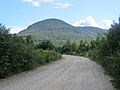
North Bald Cap as seen from Success Pond Road
-
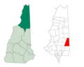
Location in Coös County, New Hampshire
See also
 In Spanish: Success (Nuevo Hampshire) para niños
