
Gorham, New Hampshire facts for kids
Quick facts for kids
Gorham, New Hampshire
|
|
|---|---|
|
Town
|
|

Buildings along Main Street
|
|
| Nickname(s):
"Switzerland of America"
|
|

Location in Coös County, New Hampshire
|
|
| Country | United States |
| State | New Hampshire |
| County | Coös |
| Incorporated | 1836 |
| Villages | |
| Area | |
| • Total | 32.3 sq mi (83.7 km2) |
| • Land | 31.8 sq mi (82.4 km2) |
| • Water | 0.5 sq mi (1.3 km2) 1.50% |
| Elevation | 794 ft (242 m) |
| Population
(2020)
|
|
| • Total | 2,698 |
| • Density | 85/sq mi (32.7/km2) |
| Time zone | UTC-5 (Eastern) |
| • Summer (DST) | UTC-4 (Eastern) |
| ZIP code |
03581
|
| Area code(s) | 603 |
| FIPS code | 33-30260 |
| GNIS feature ID | 0873607 |
Gorham is a town located in Coös County, New Hampshire, in the United States. In 2020, about 2,698 people lived there.
Gorham is nestled in the beautiful White Mountains. Parts of the White Mountain National Forest are found to its south and northwest. Moose Brook State Park is also nearby to the west. A main activity in Gorham is tourism, as many people visit to enjoy the mountains and nature. It is part of the Berlin, NH-VT Micropolitan Statistical Area.
The main part of Gorham, where most people live, is located along the Androscoggin River. This central area is found between two intersections of US 2 and NH 16.
Contents
History of Gorham

The area that is now Gorham was first given a special permission, called a "charter," in 1770 by Governor John Wentworth. It was originally part of another town called Shelburne. The first settlers arrived around 1802. For many years, Gorham was mostly made up of rocky farms, small logging businesses, and a few shops.
When Gorham officially became a town in 1836, it only had about 150 people. The town was named "Gorham" because a resident named Lot Davis suggested it. He was from Gorham, Maine, and was related to the family that started that town.
The Arrival of Railroads
The St. Lawrence and Atlantic Railroad came to Gorham in 1851. This was a big change for the town! Gorham was located halfway between Montreal and the New England coast. This made it an important railroad town. It had a large area for locomotives and a place to fix trains.
With the trains came tourists. Many hotels like the Mount Madison House and Alpine House opened up. People traveled from Boston to the White Mountains. From there, they could go to the Glen House in Pinkham Notch and Mount Washington.
The Mount Washington Auto Road
In 1861, travelers made the first trip up the Mount Washington Carriage Road. This road winds for about 8 miles (13 km) to the top of the 6,288-foot (1,917 m) mountain. Building "The Road to the Sky" was an amazing engineering achievement for its time. It was even advertised as the "first man-made attraction in the United States." Today, it is called the Mount Washington Auto Road and is still very popular.

Railroads also helped local businesses. They carried goods for mills that used water power from the Androscoggin River. The logging industry grew, with companies like Libby and Peabody making lumber. Over time, both logging and railroads became less important.
In 1973, the town's train depot, built in 1907, was going to be torn down. But the Gorham Historical Society saved the building! It is now their headquarters and a museum. The museum shows the history of the area and has old locomotives, boxcars, and a caboose.
Geography of Gorham
Gorham covers a total area of about 83.7 square kilometers (32.3 square miles). Most of this area, about 82.4 square kilometers (31.8 square miles), is land. The rest, about 1.3 square kilometers (0.5 square miles), is water.
Rivers and Mountains
The town of Gorham gets its water from the Androscoggin River. Other smaller rivers and streams, like the Peabody and Moose rivers, also flow through the area. All of Gorham is part of the Androscoggin River watershed.
Gorham is surrounded by other towns and natural areas. To the north is Berlin, and to the east is Shelburne. The highest point in Gorham is on a part of Mount Madison, reaching about 3,030 feet (924 meters) above sea level. While larger mountains surround Gorham, a smaller peak within the town is Pine Mountain, which is about 2,400 feet (730 meters) high.
Roads in Gorham
New Hampshire Route 16 and U.S. Route 2 both pass right through the center of Gorham. Route 16 goes south through Pinkham Notch to North Conway. It goes north into the city of Berlin. Route 2 heads east into Maine and west through Randolph to Lancaster.
Nearby Towns
- Berlin (north)
- Success (northeast)
- Shelburne (east)
- Purchase (southeast)
- Martin's Location (south)
- Thompson and Meserve's Purchase (southwest)
- Low and Burbank's Grant (southwest)
- Randolph (west)
Population of Gorham

According to the census of 2010, there were 2,848 people living in Gorham. There were 1,301 households, which are groups of people living together in a home. About 802 of these were families.
Most people in Gorham are white, making up about 97% of the population. A small number of people are from other backgrounds, including Asian and Native American. About 0.9% of the population identified as Hispanic or Latino.
In terms of age, about 19.4% of the people were under 18 years old. About 18.8% were 65 years or older. The average age of people in Gorham was 47 years old.

The average yearly income for a household in Gorham was about $51,190 between 2011 and 2015. For families, the average income was about $63,071.
Notable People from Gorham
- William Hatch, a politician from New Hampshire.
- Albert C. Johnston (?–1988), a doctor.
Education in Gorham
- Gorham High School is located in Gorham.
Places to Visit in Gorham
- Gorham Historical Society and Railroad Museum
- Moose Brook State Park
Images for kids
-
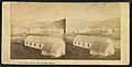
Stereoscopic photograph around 1860.
-
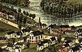
View of Gorham in 1888.
-
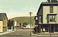
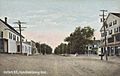
Exchange Street in 1908.
-
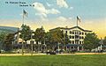
The Mount Madison House around 1912.
-
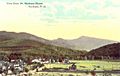
View from Mount Madison House around 1912.
-
Main Street around 1908.
-
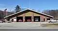
Gorham Fire Department in 2009.


See also
 In Spanish: Gorham (Nuevo Hampshire) para niños
