Martin's Location, New Hampshire facts for kids
Quick facts for kids
Martin's Location, New Hampshire
|
|
|---|---|

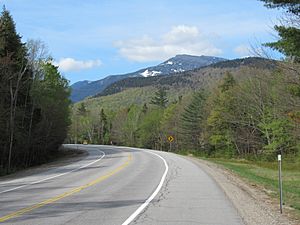
New Hampshire Route 16 in Martin's Location, May 2019. Mount Washington rises to the south, outside the township.
|
|

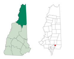
Location in Coös County, New Hampshire
|
|
| Country | United States |
| State | New Hampshire |
| County | Coös |
| Area | |
| • Total | 3.76 sq mi (9.73 km2) |
| • Land | 3.73 sq mi (9.65 km2) |
| • Water | 0.03 sq mi (0.08 km2) 0.80% |
| Elevation | 1,200 ft (400 m) |
| Population
(2020)
|
|
| • Total | 2 |
| • Density | 0.5/sq mi (0.2/km2) |
| Time zone | UTC-5 (Eastern) |
| • Summer (DST) | UTC-4 (Eastern) |
| Area code(s) | 603 |
| FIPS code | 33-007-46020 |
| GNIS feature ID | 872260 |
Martin's Location is a special kind of area in Coös County, New Hampshire, United States. It's called a "township," but it's different from a regular town. In 2020, only two people lived there! This whole area is inside the beautiful White Mountain National Forest. It's also home to the Dolly Copp Campground, a popular spot for camping.
In New Hampshire, some areas like townships, grants, and purchases are not part of any specific town. They might have very little or no local government, and many of them don't have anyone living there at all.
Contents
Exploring Martin's Location Geography
This special area is located around the Peabody River and New Hampshire Route 16. It sits just east of Mount Madison. To the north, you'll find Gorham, and to the south is Green's Grant.
The United States Census Bureau says that Martin's Location covers about 9.7 square kilometers (3.7 square miles). Most of this area is land, but about 0.80% of it is water. The Peabody River flows north through the area, and its water eventually joins the Androscoggin River. The highest point in Martin's Location is in its southeastern corner, reaching about 790 meters (2,600 feet) above sea level.
Neighboring Areas
Martin's Location shares its borders with a few other interesting places:
- Gorham (to the north)
- Bean's Purchase (to the east)
- Green's Grant (also to the east)
- Thompson and Meserve's Purchase (to the southeast)
Population Changes Over Time
| Historical population | |||
|---|---|---|---|
| Census | Pop. | %± | |
| 1860 | 19 | — | |
| 1870 | 17 | −10.5% | |
| 1880 | 33 | 94.1% | |
| 1890 | 5 | −84.8% | |
| 1910 | 3 | — | |
| 1920 | 4 | 33.3% | |
| 1960 | 2 | — | |
| 1970 | 0 | −100.0% | |
| 1980 | 0 | — | |
| 1990 | 0 | — | |
| 2000 | 0 | — | |
| 2010 | 0 | — | |
| 2020 | 2 | — | |
| U.S. Decennial Census | |||
The number of people living in Martin's Location has changed a lot over the years. In 1880, there were 33 people, which was the highest number recorded. For many years, from 1970 to 2010, no one lived there at all! However, in the 2020 census, two people were reported as living in the township.
See also
 In Spanish: Martin's Location para niños
 | Valerie Thomas |
 | Frederick McKinley Jones |
 | George Edward Alcorn Jr. |
 | Thomas Mensah |

