Green's Grant, New Hampshire facts for kids
Quick facts for kids
Green's Grant, New Hampshire
|
|
|---|---|

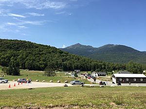
The bottom (east end) of the Mount Washington Auto Road is in Green's Grant.
|
|

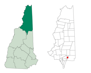
Location in Coös County, New Hampshire
|
|
| Country | United States |
| State | New Hampshire |
| County | Coös |
| Area | |
| • Total | 3.67 sq mi (9.50 km2) |
| • Land | 3.67 sq mi (9.50 km2) |
| • Water | 0.004 sq mi (0.01 km2) 0.08% |
| Elevation | 1,515 ft (462 m) |
| Population
(2020)
|
|
| • Total | 0 |
| Time zone | UTC-5 (Eastern) |
| • Summer (DST) | UTC-4 (Eastern) |
| Area code(s) | 603 |
| FIPS code | 33-007-31780 |
| GNIS feature ID | 871974 |
Green's Grant is a special kind of area in Coös County, New Hampshire, United States. It's called a "township" but it's not like a regular town. In fact, according to the 2020 census, nobody lives there!
This grant is located inside the beautiful White Mountain National Forest. It's also home to the start of the famous Mount Washington Auto Road, which leads up to the highest peak in the northeastern United States.
In New Hampshire, places like Green's Grant are called "unincorporated" areas. This means they are not part of any town and have very little (or no) local government. Many of these areas, like Green's Grant, are completely uninhabited.
Contents
History of Green's Grant
Green's Grant was named after Lieutenant Francis Green of Boston. He was a soldier who fought in the French and Indian Wars. John Wentworth, who was the British colonial governor of New Hampshire at the time, gave this land to Lieutenant Green. This was one of the last land grants that Governor Wentworth gave to soldiers.
Geography and Nature
Green's Grant covers about 3.7 square miles (9.5 km2) of land. Only a tiny part of it, about 0.08%, is covered by water.
The Peabody River flows right through the middle of Green's Grant. This river flows north and eventually joins the Androscoggin River. Smaller streams, like Nineteenmile Brook, Cowboy Brook, and the West Branch, also flow into the Peabody River here.
New Hampshire Route 16 is a road that follows the Peabody River through the grant. If you go south on this road, you'll reach Pinkham Notch in a nearby area called Pinkham's Grant. If you go north, you'll get to U.S. Route 2 in Gorham.
The highest point in Green's Grant is on its eastern edge. It's on the lower slopes of Middle Carter Mountain, where the land reaches about 2,540 feet (770 m) above sea level.
Neighboring Areas
Green's Grant is surrounded by other unique areas. These are its neighbors:
- Martin's Location (to the north)
- Bean's Purchase (to the east)
- Pinkham's Grant (to the south)
- Thompson and Meserve's Purchase (to the west)
Population Over Time
| Historical population | |||
|---|---|---|---|
| Census | Pop. | %± | |
| 1860 | 14 | — | |
| 1870 | 71 | 407.1% | |
| 1880 | 8 | −88.7% | |
| 1890 | 30 | 275.0% | |
| 1900 | 13 | −56.7% | |
| 1910 | 4 | −69.2% | |
| 1920 | 5 | 25.0% | |
| 1930 | 4 | −20.0% | |
| 1940 | 3 | −25.0% | |
| 1950 | 0 | −100.0% | |
| 1960 | 2 | — | |
| 1970 | 0 | −100.0% | |
| 1980 | 0 | — | |
| 1990 | 0 | — | |
| 2000 | 0 | — | |
| 2010 | 1 | — | |
| 2020 | 0 | −100.0% | |
| U.S. Decennial Census | |||
As you can see from the table, the number of people living in Green's Grant has changed a lot over the years. In 1870, there were 71 people, which was the most ever. But since 1950, the population has mostly been zero. The 2020 census confirmed that no one lives in Green's Grant today.
See also
 In Spanish: Green's Grant para niños
 | Victor J. Glover |
 | Yvonne Cagle |
 | Jeanette Epps |
 | Bernard A. Harris Jr. |

