West Branch Peabody River facts for kids
Quick facts for kids West Branch Peabody River |
|
|---|---|

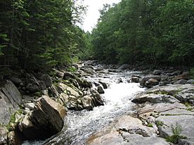
The West Branch near its confluence with the Peabody River
|
|
| Country | United States |
| State | New Hampshire |
| County | Coos |
| Townships | Thompson & Meserves Purchase, Greens Grant |
| Physical characteristics | |
| Main source | Spaulding Lake (Great Gulf) Thompson & Meserves Purchase 4,232 ft (1,290 m) 44°17′4″N 71°18′29″W / 44.28444°N 71.30806°W |
| River mouth | Peabody River Greens Grant 1,340 ft (410 m) 44°18′39″N 71°13′17″W / 44.31083°N 71.22139°W |
| Length | 5.8 mi (9.3 km) |
| Basin features | |
| Tributaries |
|
The West Branch of the Peabody River is a small river, about 5.8 miles (9.3 kilometers) long. It flows through the beautiful White Mountains in New Hampshire, United States. This river is a "tributary," which means it's a smaller stream that flows into a larger one. The West Branch joins the Peabody River. The Peabody River then flows into the Androscoggin River, which eventually reaches the Atlantic Ocean in Maine.
For most of its journey, the West Branch of the Peabody River is located inside the Great Gulf Wilderness. This is a special protected area within the White Mountain National Forest. A popular hiking path called the Great Gulf Trail follows the river, making it a favorite spot for backpackers.
Where Does the West Branch Peabody River Begin?
The West Branch of the Peabody River starts in a place called Great Gulf. This "gulf" is actually a huge bowl-shaped valley. It was carved out by glaciers a long, long time ago. This valley is on the northern side of Mount Washington, which is the tallest mountain in the northeastern U.S.
The river begins at the end of Spaulding Lake. This lake is a "tarn," a small mountain lake formed in a glacial valley. Spaulding Lake sits at the base of the east side of Mount Clay. From there, the river flows northeast, deeper into the Great Gulf. As it flows, it has Mount Jefferson to its west and Chandlers Ridge to its east. Chandlers Ridge is a part of Mount Washington.
How Does the River Flow and Where Does It End?
After flowing northeast, the West Branch of the Peabody River turns east. This happens when it reaches the area where Jefferson Ravine joins in. As it flows east, Mount Adams and Mount Madison rise high above its northern side.
The journey of the West Branch ends when it flows into the main Peabody River. This meeting point is about 1.5 miles (2.4 kilometers) north of Glen House. Glen House is a well-known spot and the entrance to the Mount Washington Auto Road.
 | Shirley Ann Jackson |
 | Garett Morgan |
 | J. Ernest Wilkins Jr. |
 | Elijah McCoy |


