Mount Clay facts for kids
Quick facts for kids Mount Clay |
|
|---|---|

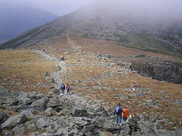
The saddle between Mount Washington and Mount Clay
|
|
| Highest point | |
| Elevation | 5,533 ft (1,686 m) |
| Prominence | 150 ft (46 m) |
| Geography | |
| Location | Thompson and Meserve's Purchase, Coös County, New Hampshire, U.S. |
| Parent range | White Mountains |
| Topo map | USGS Mount Washington |
| Climbing | |
| Easiest route | Hike |
Mount Clay is a mountain peak found in a special area called Thompson and Meserve's Purchase, located in Coos County, New Hampshire. It's part of the impressive Presidential Range, which is a group of very tall mountains within the larger White Mountains of New Hampshire. Even though it's not as famous as some of its neighbors, Mount Clay is an important part of this mountain range.
About Mount Clay
Mount Clay is like a long, gentle rise on a mountain ridge. It stretches for about 0.9 miles (1.4 kilometers) and rises a few hundred feet from the ridge it sits on. The very top of Mount Clay reaches an elevation of 5,533 feet (about 1,686 meters) above sea level. Imagine standing on top of a building that's over 1,600 meters tall!
Where is Mount Clay?
This peak is located in a wild and beautiful part of New Hampshire. It's found in Coos County, which is in the northern part of the state. Mount Clay sits right on a ridge that connects two much larger and more famous mountains. To the south-southeast, about 0.9 miles (1.4 km) away, is the mighty Mount Washington. To the north, about 1.3 miles (2.1 km) away, is Mount Jefferson. This means Mount Clay is nestled right between two giants!
How Can You Visit Mount Clay?
The easiest way to reach the summit of Mount Clay is by hiking. Many people enjoy exploring the trails in the White Mountains, and the path to Mount Clay offers amazing views. Hikers often visit Mount Clay as part of a longer trip along the Presidential Range, enjoying the challenge and the stunning scenery.
 | Isaac Myers |
 | D. Hamilton Jackson |
 | A. Philip Randolph |

