The Horn (New Hampshire) facts for kids
Quick facts for kids The Horn |
|
|---|---|

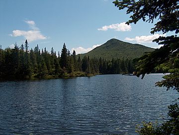
The Horn rising over Unknown Pond
|
|
| Highest point | |
| Elevation | 1,190 m (3,900 ft) |
| Prominence | 75 m (246 ft) |
| Listing | #75 New England 100 Highest |
| Geography | |
| Location | Coos County, New Hampshire |
| Parent range | Pilot Range |
| Topo map | USGS Stark |
The Horn is a mountain found in Coos County, New Hampshire. It is part of the Pilot Range. This range is a smaller part of the larger White Mountains. Another mountain called the Bulge is located near The Horn, to its southwest side.
About The Horn Mountain
The Horn is a mountain that reaches 1,190 meters (about 3,904 feet) high. It is one of the "New England 100 Highest" mountains. This means it is among the tallest peaks in the New England area.
Where the Water Flows
The rain and snow that fall on The Horn flow into different rivers. All this water eventually joins the Upper Ammonoosuc River. This river then flows into the Connecticut River. Finally, the water from The Horn reaches Long Island Sound in Connecticut.
The southern side of The Horn sends its water into the West Branch of the Upper Ammonoosuc River. Water from the northwest side flows into the West Branch of Mill Brook. This brook also joins the Upper Ammonoosuc River.
Views and Visitors
A beautiful place called Unknown Pond is located to the northeast of The Horn. From the pond, you can get a great view of the mountain peak.
However, if you are on top of The Horn, it's hard to see the pond. This is because the open rocky areas on the summit face west.
The Horn is not visited as often as other mountains in the White Mountains. This is because it is quite far from roads. It is about 5 miles (8 kilometers) from the nearest road. Its location in the northern White Mountains also makes it less busy.
 | Calvin Brent |
 | Walter T. Bailey |
 | Martha Cassell Thompson |
 | Alberta Jeannette Cassell |

