
Carroll, New Hampshire facts for kids
Quick facts for kids
Carroll, New Hampshire
|
||
|---|---|---|
|
Town
|
||

|
||
|
||

Location in Coös County, New Hampshire
|
||
| Country | United States | |
| State | New Hampshire | |
| County | Coös | |
| Incorporated | 1832 | |
| Villages |
|
|
| Area | ||
| • Total | 50.30 sq mi (130.27 km2) | |
| • Land | 50.27 sq mi (130.20 km2) | |
| • Water | 0.02 sq mi (0.06 km2) 0.05% | |
| Elevation | 1,437 ft (438 m) | |
| Population
(2020)
|
||
| • Total | 820 | |
| • Density | 16/sq mi (6.3/km2) | |
| Time zone | UTC-5 (Eastern) | |
| • Summer (DST) | UTC-4 (Eastern) | |
Carroll is a small town in Coös County, New Hampshire, United States. In 2020, about 820 people lived there. The two biggest villages in Carroll are Twin Mountain and Bretton Woods.
Carroll is a great place to visit if you love the outdoors. It's a key entry point to the White Mountains. This area has many tall mountains, including several "4,000-footers." You can also explore the Zealand River area and the Presidential Range. The town is home to the famous Mount Washington Hotel at Bretton Woods. It also has the Highland Center at Crawford Notch, which is a lodge run by the Appalachian Mountain Club.
Carroll is part of the larger Berlin, NH-VT Micropolitan Statistical Area.
Contents
History of Carroll, New Hampshire
The land that is now Carroll was first given out by Governor John Wentworth on February 8, 1772. It was given to Sir Thomas Wentworth and 81 other people. Sir Thomas Wentworth lived in England at a place called Bretton Hall. Because of this, the area was first named "Bretton Woods."
In 1832, the town was officially named Carroll. This was done to honor Charles Carroll. He was one of the people who signed the Declaration of Independence.
Early Life and Industries
Even though the land was uneven and surrounded by mountains, early farmers found the soil to be good. The town has many small streams that flow into the Ammonoosuc River. In the 1800s, these streams were known for having lots of trout.
By 1859, Carroll had a factory that made starch. It also had two lumber mills. These mills produced boards, shingles, and other wood products. Later, in 1874, a train line called the Wing Railroad reached the town.
How Tourism Shaped Carroll
Tourism became very important for Carroll. Hannah and Abel Crawford turned their log cabin into an inn. Then, they built the Notch House in 1828.
In 1874, the Boston, Concord & Montreal Railroad reached Fabyan Station. This was an important train junction. The next year, another train line, the Portland and Ogdensburg Railroad, joined it. The Fabyan House, a grand hotel, stood here. It was built by Sylvester Marsh and his partners. They also built the nearby Mount Washington Cog Railway. Sadly, the Fabyan House burned down in 1951.
The Mount Pleasant House was built in 1875 but was taken down in 1939. The most famous hotel was the Mount Washington Hotel, built in 1902. It is still open today. In 1944, a very important meeting called the International Monetary Conference was held there. This meeting led to the creation of the IMF and the World Bank.
The Logging Community of Zealand
Zealand was a logging town within Carroll. It was started by James Everell Henry around 1880. By 1884, Henry had built the Zealand Valley Railroad. This railroad went about 11 miles (18 km) into the forest.
Zealand was a company town. This means the company owned most of the buildings. It had a boarding house, a store, and a post office. The post office was open from 1883 to 1897. After most of the trees were cut down, Henry moved his logging business to Lincoln in 1892.
Later, George Van Dyke leased the land and mill from Henry. He built the Little River Railroad in 1893. After a big fire in May 1897, and with most of the lumber gone, the railroad and Zealand were left empty around 1900. You can still find a few small signs of the old Zealand community today.
Geography and Natural Features
Carroll has several villages within its borders.
- Twin Mountain is a popular place for summer and winter activities. It has a small airstrip. It's located where U.S. Route 3 and U.S. Route 302 meet.
- Bretton Woods is a resort area open all year. It's on Route 302.
- Fabyan is near Bretton Woods, where the Mount Washington Cog Railway Base Station Road meets Route 302. It used to be a train station.
- The small village of Carroll proper is about two miles north of Twin Mountain along Route 3.
New Hampshire Route 115 goes from Carroll to Jefferson. This road offers beautiful views of Whitefield, Lancaster, and the northern White Mountains.
A large part of Carroll is within the White Mountain National Forest. This includes Cherry Mountain, also called "Mount Martha," which is 3,554 feet (1,083 meters) high. The Cohos Trail runs through it. Part of the Dartmouth Range is also in Carroll. Mount Deception, at 3,670 feet (1,119 meters), is the highest point in town.
The Mount Washington Hotel is in the southeastern part of town. The Ammonoosuc River starts from several small streams and flows west through Carroll. The Saco River begins at Saco Lake in Crawford Notch and flows southeast towards the coast of Maine.
The town covers about 130.3 square kilometers (50.3 square miles). Only a tiny part, about 0.06 square kilometers (0.02 square miles), is water. Most of Carroll is in the Connecticut River watershed. This means its water flows south to Long Island Sound. A small southern tip of the town, around Saco Lake, is part of the Saco River watershed. Its water flows east to the Gulf of Maine.
Neighboring Towns and Areas
Carroll shares its borders with several other towns and grants:
- Jefferson (to the north)
- Low and Burbank's Grant (to the east)
- Crawford's Purchase (to the southeast)
- Bean's Grant (to the southeast)
- Hart's Location (to the southeast)
- Bethlehem (to the south)
- Whitefield (to the northwest)
Population Changes Over Time
| Historical population | |||
|---|---|---|---|
| Census | Pop. | %± | |
| 1830 | 108 | — | |
| 1840 | 218 | 101.9% | |
| 1850 | 296 | 35.8% | |
| 1860 | 276 | −6.8% | |
| 1870 | 378 | 37.0% | |
| 1880 | 632 | 67.2% | |
| 1890 | 813 | 28.6% | |
| 1900 | 710 | −12.7% | |
| 1910 | 569 | −19.9% | |
| 1920 | 388 | −31.8% | |
| 1930 | 402 | 3.6% | |
| 1940 | 496 | 23.4% | |
| 1950 | 359 | −27.6% | |
| 1960 | 295 | −17.8% | |
| 1970 | 310 | 5.1% | |
| 1980 | 647 | 108.7% | |
| 1990 | 528 | −18.4% | |
| 2000 | 663 | 25.6% | |
| 2010 | 763 | 15.1% | |
| 2020 | 820 | 7.5% | |
| U.S. Decennial Census | |||
The population of Carroll has changed a lot over the years. In 1830, only 108 people lived there. The population grew steadily through the 1800s, reaching over 800 people by 1890. Then, it decreased for several decades before starting to grow again in the late 20th century. By 2020, the population was 820.
Images for kids
-
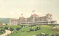
The Mount Washington Hotel around 1906
-
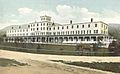
The Fabyan House around 1908
-
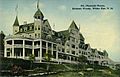
The Mt. Pleasant House around 1912
-
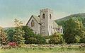
Stickney Memorial Chapel around 1910


See also
 In Spanish: Carroll (Nuevo Hampshire) para niños
