
Bean's Grant, New Hampshire facts for kids
Quick facts for kids
Bean's Grant, New Hampshire
|
|
|---|---|

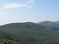
View of Mount Pierce
|
|

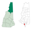
Location in Coös County, New Hampshire
|
|
| Country | United States |
| State | New Hampshire |
| County | Coös |
| Area | |
| • Total | 9.7 sq mi (25.0 km2) |
| • Land | 9.7 sq mi (25.0 km2) |
| • Water | 0 sq mi (0 km2) 0% |
| Elevation | 3,040 ft (930 m) |
| Population
(2020)
|
|
| • Total | 0 |
| Time zone | UTC-5 (Eastern) |
| • Summer (DST) | UTC-4 (Eastern) |
| Area code(s) | 603 |
| FIPS code | 33-007-04100 |
Bean's Grant is a special kind of area in Coös County, New Hampshire, United States. It's a "township" that's not really a town. This area is located north of Crawford Notch State Park. It's completely inside the beautiful White Mountain National Forest. As of the 2020 census, nobody lives here full-time.
In New Hampshire, places like grants, townships, and purchases are parts of a county that don't belong to any town. They have very little or no local government. Many of these areas, like Bean's Grant, are empty.
Contents
History of Bean's Grant
How Bean's Grant Got Its Name
Back in 1851, the government of New Hampshire decided to sell off some public land. They appointed a special person, James Willey, to handle these sales.
In 1855, James Willey sold this particular area to Charles Bean from Maine. That's how it got the name "Bean's Grant." It was a large piece of land, about 3,300 acres (13.4 square kilometers).
Geography and Nature
Where is Bean's Grant?
Bean's Grant covers about 9.7 square miles (25.0 square kilometers) of land. There's no water area within its borders.
It shares its edges with several other interesting places:
- To the east, it's next to Chandler's Purchase.
- To the southeast, you'll find Cutt's Grant.
- To the southwest, it borders Hart's Location and Carroll.
- To the northwest, it's next to Crawford's Purchase.
Roads and Mountains
The main road in Bean's Grant is called Base Road. It connects to Jefferson Notch Road and leads to the famous Cog Railway at Marshfield Station.
Many tall mountains from the Presidential Range are found here. These include Mount Pierce, Mount Jackson, and Mount Webster. The famous Appalachian Trail goes right over these mountains.
The highest point in Bean's Grant is the top of Mount Pierce, which is 4,310 feet (1,314 meters) above sea level. Water from the streams here flows into either the Saco River to the east or the Ammonoosuc River to the west.
Hiking Trails
Bean's Grant is a popular spot for hikers. Many trails start here and lead up to the Presidential Range. The well-known Crawford Path is one of them. These trails begin near Saco Lake or further south in Crawford Notch.
Population
| Historical population | |||
|---|---|---|---|
| Census | Pop. | %± | |
| 1960 | 0 | — | |
| 1970 | 0 | — | |
| 1980 | 0 | — | |
| 1990 | 0 | — | |
| 2000 | 0 | — | |
| 2010 | 0 | — | |
| 2020 | 0 | — | |
| U.S. Decennial Census | |||
As of the 2020 census, no one lives permanently in Bean's Grant. However, some people stay here seasonally. They might be visiting the AMC hut at Mizpah Spring. This hut is located along the Appalachian Trail and provides shelter for hikers.
Images for kids
-
View of Mount Pierce
-
Location in Coös County, New Hampshire
See also
 In Spanish: Bean's Grant para niños
