Chandler's Purchase, New Hampshire facts for kids
Quick facts for kids
Chandler's Purchase, New Hampshire
|
|
|---|---|

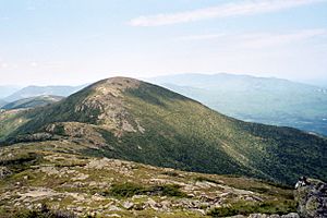
Mount Eisenhower, June 2006
|
|

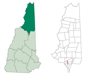
Location in Coös County, New Hampshire
|
|
| Country | United States |
| State | New Hampshire |
| County | Coös |
| Area | |
| • Total | 2.1 sq mi (5.5 km2) |
| • Land | 2.1 sq mi (5.5 km2) |
| • Water | 0 sq mi (0 km2) 0% |
| Elevation | 2,600 ft (800 m) |
| Population
(2020)
|
|
| • Total | 0 |
| Time zone | UTC-5 (Eastern) |
| • Summer (DST) | UTC-4 (Eastern) |
| Area code(s) | 603 |
| FIPS code | 33-007-11220 |
Chandler's Purchase is a special kind of area called a township. It is found in Coös County, New Hampshire, in the United States. This entire area is inside the White Mountain National Forest.
As of the 2020 census, no one lives here. It is the smallest township in Coös County by size. In New Hampshire, "purchases" are areas that are not part of any town. They have very little or no local government. Many of them, like Chandler's Purchase, are not lived in.
Contents
History of Chandler's Purchase
Chandler's Purchase gets its name from Jeremiah Chandler. He was from Conway. In 1835, he bought about 10,000 acres (40 square kilometers) of land. He paid $300 for it to a commissioner named James Willey.
Geography and Nature
Chandler's Purchase covers about 5.5 square kilometers (2.1 square miles) of land. There are no large bodies of water here. However, streams like the Ammonoosuc River flow through the area.
The highest point in Chandler's Purchase is the top of Mount Eisenhower. This mountain stands about 4,780 feet (1,457 meters) above sea level.
Roads and Trails
Two main roads cross Chandler's Purchase.
- Base Station Road: This road goes east to the Marshfield Base Station. This is where the Mount Washington Cog Railway starts. It also goes west to Bretton Woods. Hikers can find parking here for trails like the Jewell Trail. The Ammonoosuc Ravine Trail also starts nearby. Both of these trails lead to the top of Mount Washington.
- Jefferson Notch Road: This is a dirt road. It goes north from Base Station Road. It crosses over Jefferson Notch. This road leads to the Israel River valley in the town of Jefferson.
Neighboring Areas
Chandler's Purchase is surrounded by several other special areas. These are also mostly uninhabited "grants" or "purchases."
- Low and Burbank's Grant (to the north)
- Thompson and Meserve's Purchase (to the northeast)
- Sargent's Purchase (to the east)
- Cutt's Grant (to the southeast)
- Bean's Grant (to the west)
- Crawford's Purchase (to the northwest)
Population Information
| Historical population | |||
|---|---|---|---|
| Census | Pop. | %± | |
| 1890 | 15 | — | |
| 1960 | 0 | — | |
| 1970 | 0 | — | |
| 1980 | 0 | — | |
| 1990 | 0 | — | |
| 2000 | 0 | — | |
| 2010 | 0 | — | |
| 2020 | 0 | — | |
| U.S. Decennial Census | |||
According to the 2020 census, no people live in Chandler's Purchase. It has been uninhabited for many years.
See also
 In Spanish: Chandler's Purchase para niños
 | James B. Knighten |
 | Azellia White |
 | Willa Brown |

