Mount Eisenhower facts for kids
Quick facts for kids Mount Eisenhower |
|
|---|---|

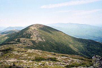
Mount Eisenhower, June 2006
|
|
| Highest point | |
| Elevation | 4,760 ft (1,450 m) |
| Prominence | 350 ft (110 m) |
| Listing | White Mountain 4000-Footers |
| Geography | |
| Location | Chandler's Purchase, Coös County, New Hampshire, U.S. |
| Parent range | Presidential Range |
| Topo map | USGS Stairs Mountain |
| Climbing | |
| First ascent | Possibly Darby Field in June 1642, though no one has proven this yet. |
| Easiest route | Edmands Path, Mt. Eisenhower Loop |
Mount Eisenhower is a cool mountain in New Hampshire, USA. It's part of the Presidential Range, which is a group of mountains named after U.S. Presidents. This mountain stands about 4,760 feet (1,451 meters) tall.
The mountain used to be called Mount Pleasant. It was renamed in honor of Dwight D. Eisenhower, who was a famous general and later the 34th President of the United States. From the top of Mount Eisenhower, you can see amazing views in every direction! You can't drive to the very top, so hikers need to walk to reach the summit.
Contents
What is Mount Eisenhower?
Mount Eisenhower is located in the White Mountains of New Hampshire. It's a popular spot for hikers because of its beautiful scenery. The mountain is known for its open, rocky summit. This means there are no trees blocking your view at the very top.
How Was Mount Eisenhower Named?
For a long time, this mountain was known as Mount Pleasant. But in 1969, the New Hampshire government decided to change its name. They wanted to honor Dwight D. Eisenhower, who had been a very important U.S. President. The U.S. Board on Geographic Names officially agreed to the new name in 1970.
Hiking Trails on Mount Eisenhower
Many people enjoy hiking Mount Eisenhower. There are several paths that lead to or near its summit.
The Appalachian Trail Connection
The famous Appalachian Trail crosses Mount Eisenhower. This trail is a very long hiking path that goes all the way from Georgia to Maine. Near the summit of Mount Eisenhower, the Appalachian Trail briefly separates from a loop trail. It then rejoins it a little further along.
Popular Hiking Routes
One of the shortest ways to reach the top of Mount Eisenhower is by taking the Edmands Path. This trail starts from a parking lot on Mount Clinton Road. Another very popular route is the Crawford Path. This path also starts near Mount Clinton Road, close to U.S. Route 302.
Nearby Peaks
Mount Eisenhower is part of a group of mountains in the Presidential Range. To its northeast, you'll find Mount Monroe. To its southwest is Mount Pierce. All three of these mountains are part of the "four-thousand footers" list. This list includes all the mountains in New Hampshire that are over 4,000 feet tall. There's also an "unofficial" peak called Mount Franklin located between Mount Eisenhower and Mount Monroe. It's not on the main list because it's not quite tall enough on its own.
 | Aaron Henry |
 | T. R. M. Howard |
 | Jesse Jackson |


