Mount Monroe facts for kids
Quick facts for kids Mount Monroe |
|
|---|---|

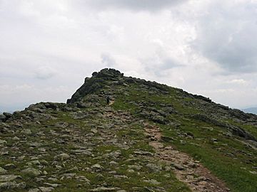
Summit of Mount Monroe (Summer 2006)
|
|
| Highest point | |
| Elevation | 5,372 ft (1,637 m) |
| Prominence | 254 ft (77 m) |
| Parent peak | Mount Washington |
| Listing | White Mountain 4000-Footers |
| Geography | |
| Country | United States |
| State | New Hampshire |
| District | Coös County |
| Parent range | Presidential Range |
| Subdivisions | Sargent's Purchase |
| Topo map | USGS Mount Washington |
| Climbing | |
| Easiest route | Hike |
Mount Monroe is a tall mountain in New Hampshire, United States. It stands 5,372 feet (1,637 meters) high. It is located southwest of Mount Washington in the Presidential Range. This mountain range is part of the White Mountains.
Mount Monroe is named after an American president, James Monroe. It is also the fourth highest mountain in New Hampshire that is over 4,000 feet tall! The famous Appalachian Trail goes right by its top. This makes it a special spot for hikers. Near Mount Monroe, you will find the beautiful Lakes of the Clouds. There is also a cozy AMC hut there for hikers to rest. This hut is located in the low area (called a col) between Mount Monroe and Mount Washington.
Contents
Reaching the Summit
Mount Monroe is between Mount Washington and Mount Eisenhower. You cannot drive a car to the top of Mount Monroe. But you can reach its summit using several hiking trails.
Popular Hiking Trails
The most direct way to hike to the top starts from the valley below. You would mostly use the Ammonoosuc Ravine Trail. This trail begins near the base station of the Mount Washington Cog Railway. After climbing up to the Lakes of the Clouds Hut, hikers then take the Crawford Path. Finally, they use the Monroe Loop trail to reach the summit.
Other ways to the top include starting from Crawford Notch on the Crawford Path. You can also combine this with the Edmands Path. This path starts from Mount Clinton Road. The final climb to the summit is always on the Monroe Loop.
Combining Hikes
From the east, hikers can reach Monroe using trails like the Boott Spur, Tuckerman Ravine, or Lion Head trails. They would then connect to other trails. Many hikers also come from the summit of Mount Washington. You can reach Mount Washington by foot, by car, or by the Cog Railway. From there, you can follow the Crawford Path to Monroe. Hikers often visit Monroe along with Washington or Eisenhower. Sometimes they visit other nearby peaks too.
Amazing Views
Mount Monroe offers truly amazing views. You can look across the Lakes of the Clouds to its huge neighbor, Mount Washington. Mount Washington is over 900 feet taller! You can also see Mount Jefferson and Mount Clay north of Washington. To the south, you can spot Boott Spur and Mount Isolation.
Looking west, you will see along the southern part of the Presidential Range. You can also see through the Dry River valley. Beyond that, you can see more of the White Mountains and even Vermont.
Unique Environment
Just like Mount Washington, the higher parts of Mount Monroe are above the tree line. This means no trees grow there. It is a sub-arctic tundra climate zone. The weather here can change very quickly. It is often very severe, especially from late fall to early spring.
Monroe Lawn and Rare Plants
One special part of the mountain is the mostly flat Monroe Lawn. This area is south of the summit. The Crawford Path goes across it. The Monroe Lawn is home to several rare plant species. This includes the endangered Robbins Cinquefoil. These plants can survive in this harsh, cold climate and rocky land. Other plants cannot grow here. To protect these fragile plants, visitors must stay strictly on the trail when crossing the Lawn.
Mountain Features
Mount Monroe has some smaller peaks nearby. "Little Monroe" is west of the main peak and about 175 feet shorter. Mount Franklin is southwest of the summit and is almost 5,000 feet above sea level.
Like much of the Presidential Range, Mount Monroe has very steep sides. These are on its northwest and southeast. This makes for very hard climbs from the valley below. These steep sides also create many waterfalls. You can see many of them along the Ammonoosuc Ravine Trail. The mountain sides are also often marked by landslides.
 | Ernest Everett Just |
 | Mary Jackson |
 | Emmett Chappelle |
 | Marie Maynard Daly |


