Boott Spur facts for kids
Quick facts for kids Boott Spur |
|
|---|---|

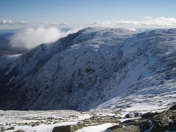
Boott Spur rising above Tuckerman Ravine in late fall.
|
|
| Highest point | |
| Elevation | 5,492 ft (1,674 m) |
| Prominence | 92 ft (28 m) |
| Parent peak | Mount Washington |
| Geography | |
| Location | Sargent's Purchase, New Hampshire, U.S. |
| Parent range | Presidential Range |
| Topo map | USGS Mount Washington |
| Climbing | |
| Easiest route | Hike via Boott Spur Trail |
Boott Spur is a smaller mountain peak found in Coos County, New Hampshire. It's named after Dr. Francis Boott, who lived from 1792 to 1863. This peak is part of the Presidential Range, which is a famous group of mountains in the White Mountains. Boott Spur sits right next to Mount Washington, which is the tallest mountain in the northeastern United States. You can find it just above the southern part of Tuckerman Ravine, a well-known glacial cirque.
Even though Boott Spur is over 4,000 feet (about 1,219 meters) tall, it's not officially called a "four-thousand footer" by the Appalachian Mountain Club. This is because it doesn't rise high enough on its own from the land connecting it to Mount Washington. It's considered more like a smaller part of Mount Washington, rather than a completely separate mountain peak.
Contents
Exploring Boott Spur: Trails and Views
Boott Spur is a great place for hiking, with trails that offer amazing views. These trails let you explore different parts of the mountain and connect to other famous paths.
Boott Spur Trail: Your Path to the Top
The Boott Spur Trail starts on the eastern side of the mountain. It begins about 0.4 miles (0.6 kilometers) above the Pinkham Notch visitors' center, right off the Tuckerman Ravine Trail. As you hike, you'll first go through forests and then reach open areas above the treeline. This part of the trail gives you fantastic views of the surrounding mountains and valleys. The Boott Spur Trail eventually meets up with the Davis Path, about 3.4 miles (5.5 kilometers) from the Pinkham Notch visitors' center.
Davis Path: A Historic Mountain Route
The Davis Path is a long trail, about 14 miles (22.5 kilometers) in length. It was first built a long time ago, in 1844-1845. This path goes from U.S. Route 302 in Crawford Notch, up a ridge called Montalban Ridge, and then over Boott Spur. It continues all the way to the very top of Mount Washington.
Glen Boulder Trail: Another Way Up
Another trail that climbs Boott Spur is the Glen Boulder Trail. It starts from the southeast, near the parking area for Glen Ellis Falls on New Hampshire Route 16. This trail takes you past a large rock called the Glen Boulder. It also goes over a smaller peak named Gulf Peak, which is about 4,806 feet (1,465 meters) high. Gulf Peak is also known as Slide Peak. After passing Gulf Peak, the Glen Boulder Trail joins the Davis Path, just south of Boott Spur's summit. Gulf Peak is a popular spot for hikers who enjoy challenging trails.
 | Bessie Coleman |
 | Spann Watson |
 | Jill E. Brown |
 | Sherman W. White |

