Johns River (New Hampshire) facts for kids
Quick facts for kids Johns River |
|
|---|---|

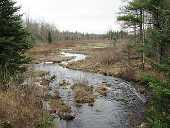
The Johns River downstream from its source at Cherry Pond
|
|
| Country | United States |
| State | New Hampshire |
| County | Coos |
| Towns | Jefferson, Whitefield, Dalton |
| Physical characteristics | |
| Main source | Cherry Pond Jefferson 1,109 ft (338 m) 44°22′26″N 71°31′8″W / 44.37389°N 71.51889°W |
| River mouth | Connecticut River Dalton 837 ft (255 m) 44°25′35″N 71°40′34″W / 44.42639°N 71.67611°W |
| Length | 14 mi (23 km) |
| Basin features | |
| Tributaries |
|
The Johns River is a river located in northern New Hampshire, a state in the United States. It starts at a place called Cherry Pond in the town of Jefferson. From there, it flows about 14 miles (23 km) generally towards the northwest. Its journey ends when it joins the larger Connecticut River.
Contents
Where Does the Johns River Flow?
The Johns River begins its path in Jefferson. It then flows through Hazens Pond, which is close to the Mount Washington Regional Airport. After that, it travels through the town of Whitefield. In Whitefield, a major road, U.S. Route 3, crosses over the river. Finally, the river makes its way through the town of Dalton before it meets the Connecticut River.
What is the Source of the Johns River's Water?
The Johns River gets its water from many smaller ponds and streams. These are all part of its "river basin" or "watershed." A watershed is like a big bowl where all the rain and snowmelt collect and flow into one main river.
Ponds and Lakes Feeding the River
Many small bodies of water contribute to the Johns River. These include:
- Martin Meadow Pond
- Weeks Pond
- Weed Pond
- Clark Pond
- Burns Pond (which used to be called Long Pond)
- Richardson Pond/Marsh
- Hazens Pond
- Cherry Pond and Little Cherry Pond (where the river starts)
- Forest Lake
- Mirror Lake (which used to be called Blake Pond)
Streams and Brooks Joining the Johns River
Several smaller streams, known as tributaries, flow into the Johns River, adding to its volume. These include:
- Chase Brook
- Carroll Stream
- Bear Brook
- Leonard Brook
- Cherry Mountain Brook
- Carter Brook
- Bog Brook
Mountains Around the River's Basin
The area that drains into the Johns River is surrounded by mountains. These mountains help define the watershed. The boundaries of the watershed are:
- The eastern side of the Dalton Mountain Range
- The southern side of Prospect Mountain
- The western side of Cherry Mountain (also known as Mount Martha)
How Did the Johns River Get Its Name?
The Johns River is named after an early hunter and trapper named John Glines. He lived in the area during the 1700s. John Glines set up a camp for fishing and hunting in this region. Another river nearby, called the Israel River, is named after John's brother, Israel.
 | Precious Adams |
 | Lauren Anderson |
 | Janet Collins |


