Wild Ammonoosuc River facts for kids
Quick facts for kids Wild Ammonoosuc River |
|
|---|---|

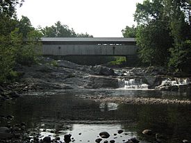
Swiftwater Covered Bridge over the Wild Ammonoosuc
|
|
| Country | United States |
| State | New Hampshire |
| County | Grafton |
| Towns | Woodstock, Easton, Landaff, Bath |
| Physical characteristics | |
| Main source | Beaver Pond Kinsman Notch, Woodstock 1,850 ft (560 m) 44°2′39″N 71°47′35″W / 44.04417°N 71.79306°W |
| River mouth | Ammonoosuc River Bath 462 ft (141 m) 44°9′16″N 71°58′52″W / 44.15444°N 71.98111°W |
| Length | 14.9 mi (24.0 km) |
| Basin features | |
| Tributaries |
|
The Wild Ammonoosuc River is a cool river in northwestern New Hampshire, United States. It's about 15 miles (24 km) long. This river is a tributary, which means it's a smaller river that flows into a bigger one. The Wild Ammonoosuc flows into the Ammonoosuc River.
Together, these rivers are part of a larger watershed that eventually leads to the Connecticut River. The Connecticut River then travels all the way to Long Island Sound.
Contents
About the Wild Ammonoosuc River
The Wild Ammonoosuc River flows entirely within Grafton County. It starts high up in the White Mountains.
Where the River Begins
The river's journey begins at a place called Kinsman Notch. This spot is in the town of Woodstock. From there, the river flows mostly towards the northwest.
The River's Path
As it travels, the Wild Ammonoosuc River passes through a few towns. These towns include Easton and Landaff. Finally, it reaches the town of Bath.
Joining the Ammonoosuc
In Bath, the Wild Ammonoosuc River meets up with the Ammonoosuc River. This is where its journey as a separate river ends. If you want to follow the river, New Hampshire Route 112 runs right alongside it for its whole length.
 | Kyle Baker |
 | Joseph Yoakum |
 | Laura Wheeler Waring |
 | Henry Ossawa Tanner |


