Landaff, New Hampshire facts for kids
Quick facts for kids
Landaff, New Hampshire
|
|
|---|---|
|
Town
|
|

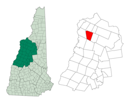
Location in Grafton County, New Hampshire
|
|
| Country | United States |
| State | New Hampshire |
| County | Grafton |
| Incorporated | 1774 |
| Villages |
|
| Area | |
| • Total | 28.48 sq mi (73.75 km2) |
| • Land | 28.34 sq mi (73.40 km2) |
| • Water | 0.14 sq mi (0.35 km2) 0.48% |
| Elevation | 1,142 ft (348 m) |
| Population
(2020)
|
|
| • Total | 446 |
| • Density | 16/sq mi (6.1/km2) |
| Time zone | UTC-5 (Eastern) |
| • Summer (DST) | UTC-4 (Eastern) |
| ZIP codes | |
| Area code(s) | 603 |
| FIPS code | 33-40660 |
| GNIS feature ID | 0873641 |
Landaff is a small town located in Grafton County, New Hampshire, in the United States. In 2020, about 446 people lived there. It's a quiet place with a rich history and beautiful natural surroundings.
Contents
History of Landaff
The town of Landaff got its name from "Llandaff." This name honored the Bishop of Llandaff, who was a chaplain to England's King George III.
Early Grants and Settlers
The land was first given to James Avery and 60 other people on January 31, 1764. This official paper was called a "charter." However, these first settlers did not follow the rules of the charter. Because of this, they lost their right to the land.
So, the land was given again, or "re-granted," to Dartmouth College on January 19, 1770.
Dartmouth College and Town Incorporation
Under Dartmouth College's ownership, people started to settle there. They built roads and a mill. On November 11, 1774, Landaff officially became a town. This process is called "incorporation."
After the American Revolutionary War, the first group of people who had been granted the land said they had lost their rights unfairly. They won their case, and Dartmouth College had to give up its claim to the land. The college lost all the money it had spent on building things there.
Changes to Town Borders
Landaff used to be much bigger than it is today. Its borders changed over the years because of decisions made by the New Hampshire General Court (the state's government).
- On July 2, 1845, Landaff gained a small piece of land from the nearby town of Lincoln.
- On June 23, 1859, all the land in Landaff that was northwest of the Ammonoosuc River became part of the town of Lisbon.
- On July 20, 1876, the town was split in half. The eastern part became a new town called Easton.
Geography of Landaff
Landaff is in the northwestern part of New Hampshire and Grafton County. It is about 14 miles (23 km) southwest of Littleton and 9 miles (14 km) east of Woodsville.
Land and Water Features
The town covers a total area of about 28.5 square miles (73.8 square kilometers). Most of this is land, with a small amount of water. The highest point in Landaff is the top of Moody Ledge, which is 2,326 feet (709 meters) above sea level.
The Ammonoosuc River forms part of the town's northwestern border. The Wild Ammonoosuc River flows through the southern part of Landaff. All the water in Landaff eventually flows into the Connecticut River watershed. This means all the streams and rivers here drain into the Connecticut River.
Natural Areas
The southern half of Landaff is part of the White Mountain National Forest. You can explore this forest using trails like Cobble Hill Trail and Ore Hill Trail. Landaff has many beautiful natural spots, including mountain views, wetlands, and large areas of undeveloped forests and farmlands. The main ponds in town are Chandler Pond, Jericho Pond, and Gordon Pond.
Wildlife in Landaff
Landaff is home to many different kinds of animals. You might see black bears, moose, white-tailed deer, beavers, and eastern turkeys. Coyotes also live in the thousands of open acres. Other birds like ruffed grouse can be found here too.
Recreation
There are many chances to enjoy the outdoors in Landaff. People can go hunting, fishing, and cross-country skiing. Snowshoeing, hiking, and watching nature are also popular activities. In winter, snowmobiling is a favorite pastime.
Population and People
| Historical population | |||
|---|---|---|---|
| Census | Pop. | %± | |
| 1790 | 292 | — | |
| 1800 | 461 | 57.9% | |
| 1810 | 650 | 41.0% | |
| 1820 | 769 | 18.3% | |
| 1830 | 951 | 23.7% | |
| 1840 | 957 | 0.6% | |
| 1850 | 948 | −0.9% | |
| 1860 | 1,012 | 6.8% | |
| 1870 | 882 | −12.8% | |
| 1880 | 506 | −42.6% | |
| 1890 | 499 | −1.4% | |
| 1900 | 500 | 0.2% | |
| 1910 | 526 | 5.2% | |
| 1920 | 510 | −3.0% | |
| 1930 | 469 | −8.0% | |
| 1940 | 389 | −17.1% | |
| 1950 | 342 | −12.1% | |
| 1960 | 289 | −15.5% | |
| 1970 | 292 | 1.0% | |
| 1980 | 266 | −8.9% | |
| 1990 | 350 | 31.6% | |
| 2000 | 378 | 8.0% | |
| 2010 | 415 | 9.8% | |
| 2020 | 446 | 7.5% | |
| U.S. Decennial Census | |||
In 2000, there were 378 people living in Landaff. These people lived in 154 households, and 107 of these were families. The population density was about 13 people per square mile (5 people per square kilometer).
About 29% of the households had children under 18 living with them. Most households (61.7%) were married couples living together. The average household had about 2.45 people.
The population included people of different ages. About 23.8% were under 18 years old. About 14.8% were 65 years or older. The average age in the town was 42 years.
Notable People from Landaff
- Abigail Abbot Bailey (1746–1815), a writer of memoirs
- Harry Chandler (1864–1944), a newspaper publisher and real estate investor
- Mary Noyes Farr (1853–1938), a doctor and educator
- Samuel H. Roys (1821–1857), a politician from Wisconsin
See also
 In Spanish: Landaff (Nuevo Hampshire) para niños
 | William Lucy |
 | Charles Hayes |
 | Cleveland Robinson |


