
Groton, New Hampshire facts for kids
Quick facts for kids
Groton, New Hampshire
|
|
|---|---|

|
|

Location in Grafton County, New Hampshire
|
|
| Country | United States |
| State | New Hampshire |
| County | Grafton |
| Incorporated | 1761 |
| Villages | Groton North Groton |
| Area | |
| • Total | 40.8 sq mi (105.6 km2) |
| • Land | 40.7 sq mi (105.4 km2) |
| • Water | 0.08 sq mi (0.2 km2) 0.16% |
| Elevation | 636 ft (194 m) |
| Population
(2020)
|
|
| • Total | 569 |
| • Density | 14/sq mi (5.4/km2) |
| Time zone | UTC-5 (Eastern) |
| • Summer (DST) | UTC-4 (Eastern) |
| ZIP code | |
| Area code(s) | 603 |
| FIPS code | 33-32180 |
| GNIS feature ID | 0873614 |
Groton is a small and peaceful town located in Grafton County, New Hampshire, United States. According to the 2020 census, 569 people live here. It's a great place to learn about history and nature.
Contents
Groton's Early History
Groton was first called "Cockermouth." This name honored Charles Wyndham, who was a British official. The town was first officially created in 1761.
However, not many people settled there at first. So, the land was given out again in 1766 and then once more in 1772. In 1796, one of the new landowners, Samuel Blood, successfully changed the town's name. He named it "Groton" after his own hometown in Groton, Massachusetts.
Farming and Mills in Groton
Even though Groton's land is hilly, early farmers found good soil. They grew crops like corn and potatoes. Rivers and streams were very important. A branch of the Baker River in the north and small streams feeding Newfound Lake in the south provided water power.
This water power was used for mills. By 1859, when 776 people lived in Groton, there were many mills. These included ten sawmills for cutting wood and two gristmills for grinding grain. There was also a factory that made shingles and clapboards for building houses.
Minerals and Modern Energy
Groton is also known for its minerals. The Palermo Mine in North Groton has many interesting minerals, though it is not open to the public.
In more recent times, Groton has looked towards modern energy. On August 4, 2009, the town decided to allow a wind farm to be built. This wind farm was constructed by a company called Iberdrola Renewables.
Geography and Nature
Groton covers about 105.6 square kilometers (about 40.8 square miles) in total. Most of this area is land, with only a small part being water.
The highest point in Groton is the top of Tenney Mountain. It stands at about 636 meters (2,087 feet) above sea level. The Cockermouth River, which flows into Newfound Lake, runs through the middle of the town. All the water in Groton eventually flows into the Merrimack River.
Population Changes Over Time
Groton's population has changed a lot over the years. Here's how it has grown and shrunk:
- In 1790, there were 373 people.
- By 1850, the population was 776.
- It then decreased to 99 people in 1960.
- Since then, the population has slowly grown again.
- In 2020, 569 people lived in Groton.
The average age of people in Groton in 2000 was 40 years old. About 25.9% of the population was under 18 years old.
Education in Groton
Students in Groton attend schools within the Newfound Area School District. For middle school, students go to Newfound Memorial Middle School. High school students attend Newfound Regional High School, which is located in Bristol.
Images for kids
-
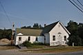
Highway Department building (former library)
-
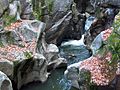
Sculptured Rocks, Cockermouth River
-
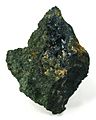
Vivianite from North Groton
-
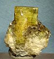
Beryl from North Groton


See also
 In Spanish: Groton (Nuevo Hampshire) para niños
