Cockermouth River facts for kids
Quick facts for kids Cockermouth River |
|
|---|---|

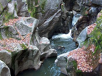
The Cockermouth in Sculptured Rocks Natural Area
|
|
| Country | United States |
| State | New Hampshire |
| County | Grafton |
| Towns | Groton, Hebron |
| Physical characteristics | |
| Main source | Province Road State Forest Groton 1,500 ft (460 m) 43°44′37″N 71°55′5″W / 43.74361°N 71.91806°W |
| River mouth | Newfound Lake Hebron 588 ft (179 m) 43°41′34″N 71°47′39″W / 43.69278°N 71.79417°W |
| Length | 9.5 mi (15.3 km) |
| Basin features | |
| Tributaries |
|
The Cockermouth River is a cool stream located in central New Hampshire, United States. It flows for about 9.5 miles (15.3 km). This river is the longest stream that flows into Newfound Lake. It's an important part of the larger Pemigewasset River and Merrimack River systems. These systems collect water from a wide area, like a giant funnel. The river got its name from an old land grant called the "Cockermouth Grant." This grant was an early name for a part of the town of Hebron.
Contents
Discover the Cockermouth River
The Cockermouth River is a beautiful natural feature in New Hampshire. It plays a key role in the local environment. Understanding rivers helps us learn about the land and how water moves through it.
River's Journey: From Source to Lake
The Cockermouth River begins in a place called Province Road State Forest. This forest is near the western edge of Groton, New Hampshire. From there, the river flows southeast. It travels all the way across the town of Groton.
As the river flows, a rough dirt road called Sculptured Rocks Road runs alongside it. This road gets easier to drive on as you go downstream. The river then enters the town of Hebron, New Hampshire. Finally, it flows into Newfound Lake near the lake's northern end.
Sculptured Rocks Natural Area
One of the most interesting places along the Cockermouth River is the Sculptured Rocks Natural Area. Here, the river has carved narrow, sharp shapes into the rocks. It's like nature's own sculpture garden! This area is a very popular spot for local people to go swimming. It's a great example of how water can shape the land over many years. After passing through these cool rock formations, the river enters a wider valley. This valley is near the village center of Groton.
What is a Watershed?
The Cockermouth River is part of a larger watershed. A watershed is an area of land where all the water drains into a single river, lake, or ocean. Think of it like a giant bowl. All the rain and snow that falls in that bowl eventually flows into the main river or lake at the bottom. The Cockermouth River's water eventually joins the Pemigewasset River. Then it flows into the Merrimack River, and finally reaches the Atlantic Ocean.
 | Chris Smalls |
 | Fred Hampton |
 | Ralph Abernathy |


