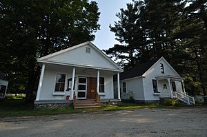
Hebron, New Hampshire facts for kids
Quick facts for kids
Hebron, New Hampshire
|
||
|---|---|---|
|
Town
|
||

Town Hall and Library
|
||
|
||

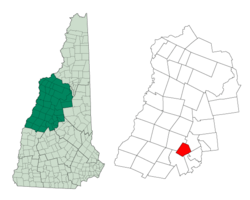
Location in Grafton County, New Hampshire
|
||
| Country | United States | |
| State | New Hampshire | |
| County | Grafton | |
| Incorporated | 1792 | |
| Villages | Hebron East Hebron |
|
| Area | ||
| • Total | 19.26 sq mi (49.88 km2) | |
| • Land | 17.01 sq mi (44.05 km2) | |
| • Water | 2.25 sq mi (5.84 km2) 11.70% | |
| Elevation | 623 ft (190 m) | |
| Population
(2020)
|
||
| • Total | 632 | |
| • Density | 37/sq mi (14.3/km2) | |
| Time zone | UTC-5 (Eastern) | |
| • Summer (DST) | UTC-4 (Eastern) | |
| ZIP code |
03241
|
|
| Area code(s) | 603 | |
| FIPS code | 33-35220 | |
| GNIS feature ID | 0873622 | |
Hebron is a small town in Grafton County, New Hampshire, in the United States. In 2020, about 632 people lived there. The town includes the main center of Hebron and the village of East Hebron.
Contents
History of Hebron
Hebron was first settled in 1765. It officially became a town in 1792. This happened when parts of two other areas, Cockermouth (now Groton) and West Plymouth, were combined. Most of the early settlers came from other towns in New England. No one from Europe is known to have moved there directly.
The land in Hebron was a bit rough, and the soil was hard to farm. Still, farming was the main job for people living there. Other businesses started to grow after the Mayhew Turnpike was built in 1803. This road helped connect towns in the north, where lumber was cut, with cities and mills in the south.
In 1859, Hebron had 565 people, one store, and a place that made leather (a tannery). By the 1920s, people started visiting Hebron for fun. Tourism became a big part of the town's economy, with summer lodges and winter skiing activities.
Geography and Nature
Hebron is located at the northern end of Newfound Lake. This lake is the fourth largest in New Hampshire. The Cockermouth River flows into the town from Groton in the west. It passes through the town center before reaching the lake. All of Hebron is part of the Merrimack River watershed.
The highest point in Hebron is a small hill. It is about 2,240 feet (683 meters) above sea level. This spot is just south of the top of Tenney Mountain.
Town Layout
The main part of town, Hebron village, is near the northwest side of Newfound Lake. It's where North Shore Road, West Shore Road, and Groton Road meet. New Hampshire Route 3A goes through the eastern part of Hebron. It follows the east shore of Newfound Lake. The village of East Hebron is near the northeast end of the lake. It's close to where Route 3A meets North Shore Road.
The United States Census Bureau says Hebron covers about 49.9 square kilometers (19.3 square miles). About 44.0 square kilometers (17.0 square miles) is land. The remaining 5.8 square kilometers (2.2 square miles) is water. This means water makes up about 11.70% of the town's total area.
Population Over Time
| Historical population | |||
|---|---|---|---|
| Census | Pop. | %± | |
| 1800 | 281 | — | |
| 1810 | 563 | 100.4% | |
| 1820 | 572 | 1.6% | |
| 1830 | 538 | −5.9% | |
| 1840 | 508 | −5.6% | |
| 1850 | 565 | 11.2% | |
| 1860 | 475 | −15.9% | |
| 1870 | 382 | −19.6% | |
| 1880 | 329 | −13.9% | |
| 1890 | 245 | −25.5% | |
| 1900 | 214 | −12.7% | |
| 1910 | 213 | −0.5% | |
| 1920 | 184 | −13.6% | |
| 1930 | 197 | 7.1% | |
| 1940 | 151 | −23.4% | |
| 1950 | 130 | −13.9% | |
| 1960 | 153 | 17.7% | |
| 1970 | 234 | 52.9% | |
| 1980 | 349 | 49.1% | |
| 1990 | 386 | 10.6% | |
| 2000 | 459 | 18.9% | |
| 2010 | 602 | 31.2% | |
| 2020 | 632 | 5.0% | |
| U.S. Decennial Census | |||
In 2000, there were 459 people living in Hebron. Most people were White (95.86%). A small number of people were from other racial groups.
About 20.4% of households had children under 18. Most households (63.1%) were married couples. The average household had 2.23 people. The average family had 2.60 people.
The population was spread out by age. About 16.1% were under 18. About 28.1% were 65 or older. The average age was 50 years old.
The median income for a household was $47,639. This means half of the households earned more, and half earned less. About 2.8% of the population lived below the poverty line.
Education in Hebron
Hebron is part of the Newfound Area School District. Younger students attend Bridgewater-Hebron Village School in Bridgewater. Older students go to Newfound Memorial Middle School. They then attend Newfound Regional High School in Bristol.
Famous People from Hebron
Several notable people have come from Hebron:
- John Ball (1794–1884) – A teacher, lawyer, and politician.
- Nathaniel S. Berry (1796–1894) – He was the governor of New Hampshire during the Civil War.
- John Ordway (1775–1817) – A sergeant in the Corps of Discovery. He helped lead the famous Lewis and Clark Expedition.
- Austin F. Pike (1819–1886) – He served as both a congressman and a senator.
See also
 In Spanish: Hebron (Nuevo Hampshire) para niños
 | William L. Dawson |
 | W. E. B. Du Bois |
 | Harry Belafonte |


