
Rumney, New Hampshire facts for kids
Quick facts for kids
Rumney, New Hampshire
|
||
|---|---|---|
|
Town
|
||

Town hall
|
||
|
||

Location in Grafton County, New Hampshire
|
||
| Country | United States | |
| State | New Hampshire | |
| County | Grafton | |
| Incorporated | 1767 | |
| Villages |
|
|
| Area | ||
| • Total | 42.6 sq mi (110.4 km2) | |
| • Land | 41.7 sq mi (108.0 km2) | |
| • Water | 0.9 sq mi (2.4 km2) 2.15% | |
| Elevation | 509 ft (155 m) | |
| Population
(2020)
|
||
| • Total | 1,498 | |
| • Density | 36/sq mi (13.9/km2) | |
| Time zone | UTC-5 (Eastern) | |
| • Summer (DST) | UTC-4 (Eastern) | |
| ZIP code |
03266
|
|
| Area code(s) | 603 | |
| FIPS code | 33-65940 | |
| GNIS feature ID | 0873711 | |

Rumney is a small town in Grafton County, New Hampshire, United States. In 2020, about 1,498 people lived there. The town is located near the southern edge of the White Mountain National Forest.
Contents
History of Rumney
Rumney was named after Robert Marsham, who was the 2nd Baron Romney. The name "Romney" is pronounced "Rumney."
The town was first given land in 1761 by Governor Benning Wentworth. This land was for settlers from Colchester and East Haddam, Connecticut. The first people settled there in 1765. However, some of the first settlers did not follow the rules of their land grant. So, Rumney was given to a new group of settlers in 1767.
The soil in Rumney was good for farming. By 1859, the town had a population of 1,109 people. Other businesses started to grow. There were fifteen sawmills, a large place for making leather (called a tannery), and a factory that made ladders. The Boston, Concord and Montreal Railroad started train service to West Rumney around 1850 or 1851.
On December 22, 1954, a group called the Automobile License Plate Collectors Association (ALPCA) was started in Rumney. This group has grown a lot. It is now an international organization with members in all 50 U.S. states and 19 other countries.
Geography and Nature
Rumney covers a total area of about 110.4 square kilometers (42.6 square miles). Most of this area is land, with a small part being water. Water makes up about 2.15% of the town.
The highest point in Rumney is about 509 meters (1,670 feet) above sea level. This spot is on the southern side of Carr Mountain. The Baker River flows through the middle of the town from west to east. New Hampshire Route 25 runs roughly next to the river. Rumney is part of the Pemigewasset River watershed, which means its water eventually flows into the Merrimack River.
Villages within Rumney
The town of Rumney has several smaller communities or villages:
- Rumney village is the main settlement. It is just north of the Baker River.
- Rumney Depot is directly south of Rumney village. It is across the Baker River and close to Route 25.
- Stinson Lake village is in the northern part of town. It includes homes around the lake of the same name and near Stinson Mountain.
- West Rumney is located along Route 25 near the western edge of the town.
Rumney is also home to Polar Caves Park. This park is famous for its interesting rock formations and glowing rocks. It is located along Route 25 near the eastern border of the town.
Rumney Rocks: A Climbing Spot
Rumney Rocks is a very popular place for rock climbing. It is located between Rumney village and West Rumney. It is especially known for its "sport climbing" routes.
Most of the climbing areas are on the many small cliffs on the south side of Rattlesnake Mountain. A large part of this area is inside the White Mountain National Forest. These cliffs are mostly made of a type of rock called schist. Some parts are made of granite. The cliffs have different shapes, from smooth, flat sections to parts that hang way out (called "overhung roofs" and "arêtes").
The cliffs vary in height. Most are between 12 and 27 meters (40 and 90 feet) tall. However, a few cliffs are over 90 meters (300 feet) high! Most of the climbing routes have bolts already in place for safety. Some routes might need extra safety gear. The difficulty of the climbs ranges from easy (5.0) to very hard (5.15a). Many routes are in the middle, between 5.10 and 5.12.
Population Over Time
| Historical population | |||
|---|---|---|---|
| Census | Pop. | %± | |
| 1790 | 411 | — | |
| 1800 | 624 | 51.8% | |
| 1810 | 765 | 22.6% | |
| 1820 | 864 | 12.9% | |
| 1830 | 993 | 14.9% | |
| 1840 | 1,110 | 11.8% | |
| 1850 | 1,109 | −0.1% | |
| 1860 | 1,103 | −0.5% | |
| 1870 | 1,165 | 5.6% | |
| 1880 | 1,056 | −9.4% | |
| 1890 | 947 | −10.3% | |
| 1900 | 837 | −11.6% | |
| 1910 | 850 | 1.6% | |
| 1920 | 911 | 7.2% | |
| 1930 | 858 | −5.8% | |
| 1940 | 861 | 0.3% | |
| 1950 | 859 | −0.2% | |
| 1960 | 820 | −4.5% | |
| 1970 | 870 | 6.1% | |
| 1980 | 1,212 | 39.3% | |
| 1990 | 1,446 | 19.3% | |
| 2000 | 1,480 | 2.4% | |
| 2010 | 1,480 | 0.0% | |
| 2020 | 1,498 | 1.2% | |
| U.S. Decennial Census | |||
In 2000, Rumney had 1,480 people living there. There were 569 households, and 393 of these were families. The average household had about 2.55 people. The average family had about 3.00 people.
About 25.4% of the population was under 18 years old. About 16.1% of the people were 65 years or older. The average age in Rumney was 41 years old.
Stereographic Cards from the 1880s
These old pictures show what Rumney looked like around 1880.
-
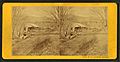
Sawmill
-
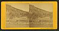
Rattlesnake Mountain
-
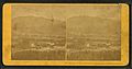
General view from train


Notable People from Rumney

Many interesting people have connections to Rumney:
- Robert Burns (1792–1866), who was a U.S. congressman.
- Nathan Clifford (1803–1881), a diplomat and a judge on the U.S. Supreme Court.
- J. J. Donovan (1858–1937), a businessman and politician from Washington state.
- Mary Baker Eddy (1821–1910), who started the Christian Science religion in 1879.
- Thom Hartmann (born 1951), an author and radio host.
- Jonathan Myles (born 1982), an Olympic luger (someone who races on a small sled down an icy track).
Places to Visit
- Mary Baker Eddy House
- Polar Caves Park
- Rumney Bible Conference
See also
 In Spanish: Rumney (Nuevo Hampshire) para niños
