
Coös County, New Hampshire facts for kids
Quick facts for kids
Coös County
|
|
|---|---|

Coös County Courthouse in Lancaster
|
|

Location within the U.S. state of New Hampshire
|
|
 New Hampshire's location within the U.S. |
|
| Country | |
| State | |
| Founded | 1803 |
| Named for | Algonquian for “small pines” |
| Seat | Lancaster |
| Largest city | Berlin |
| Area | |
| • Total | 1,830.3 sq mi (4,740 km2) |
| • Land | 1,794.6 sq mi (4,648 km2) |
| • Water | 35.7 sq mi (92 km2) 1.95% |
| Population
(2020)
|
|
| • Total | 31,268 |
| • Estimate
(2022)
|
31,504 |
| • Density | 17.4/sq mi (6.7/km2) |
| Time zone | UTC−5 (Eastern) |
| • Summer (DST) | UTC−4 (EDT) |
| Congressional district | 2nd |
Coös County (pronounced "koh-oss") is a county in the state of New Hampshire. In 2020, it had 31,268 people, making it the least populated county in New Hampshire. The main town where the county government is located is Lancaster.
Coös County is special because it's the only county in New Hampshire that shares a border with Canada. It's located just south of the province of Quebec. This means it has New Hampshire's only international border crossing, called the Pittsburg–Chartierville Border Crossing. The only city in Coös County is Berlin. All other communities are towns or special areas called townships, gores, and grants.
This county covers the northernmost part of New Hampshire. Its main industries are forestry (working with trees and wood) and tourism (people visiting for fun). The paper-making industry, which used to be very big, has become much smaller. Coös County is part of two of New Hampshire's tourism areas. The southern part is in the White Mountains Region and is home to Mount Washington, the highest peak in the northeastern United States. The rest of the county is known as the Great North Woods Region, or simply the North Country.
Contents
What's in a Name?
The name Coös comes from an old Native American word from the Cowasuck people. It means "small pines." This county is one of only two in the United States that has a special mark (called a diaeresis) over one of its letters.
Sometimes, you'll see the name written with two dots over the "o" (Coös) to show that it has two syllables when you say it. The county government uses both spellings.
A Look Back in Time
Coös County was created on December 24, 1803. It was formed from the northern part of Grafton County, New Hampshire. At first, the county government was in Berlin, but it later moved to Lancaster.
During the American Revolutionary War, two groups of soldiers, called Bedel's Regiment and Whitcomb's Rangers, were formed from the people living in Coös. After the war, there was a disagreement about the border between the northern tip of the county and Canada. For a few years, the people in that area even formed their own independent place called the Republic of Indian Stream!
In 1810, about 4,000 people lived here. By 1870, the population had grown to almost 15,000. Besides farming, early industries included working with wood (forestry) and making things in factories.
Exploring the Geography

Coös County covers about 1,830 square miles. Most of this is land (about 1,795 square miles), and a smaller part is water (about 35 square miles). It's the largest county in New Hampshire by size. It borders both Vermont and Maine, as well as Canada.
A lot of the county's mountainous areas are protected. These include parts of the White Mountain National Forest, wilderness areas, and state parks. These protected lands cover most of the northern White Mountains. This includes all the famous peaks of the Presidential Range, like Mount Washington, which is the tallest mountain in the Northeast. The Cohos Trail, a long hiking path, runs for 162 miles through the county.
Important roads in Coös County include New Hampshire Route 16, which runs near the Maine border and through Berlin. New Hampshire Route 26 goes through the Great North Woods. Two major U.S. Highways are U.S. Route 2, which crosses the county from Lancaster, and U.S. Route 3, which goes all the way to the Canadian border.
Coös County has the fewest people of all New Hampshire counties. It's also unique because it has a lot of "unincorporated land." This means that over half of its areas are not organized into towns or cities. Instead, they are townships, gores, or grants. Very few people live in these unincorporated areas. For example, only three of them (Wentworth Location, Millsfield, and Cambridge) had more than ten people in recent counts. About one-third of the county's population lives in Berlin, which is the only city and the main economic center. Lancaster is where the county government is located.
Mountains to Explore
- White Mountains (part of the White Mountain National Forest)
- Presidential Range
Neighboring Areas
Coös County shares borders with:
- Oxford County, Maine (to the east)
- Carroll County (to the southeast)
- Grafton County (to the southwest)
- Essex County, Vermont (to the west)
- Three Canadian areas in Quebec to the north:
- Coaticook Regional County Municipality, Quebec
- Le Haut-Saint-François Regional County Municipality, Quebec
- Le Granit Regional County Municipality, Quebec
Protected Natural Places
- Umbagog National Wildlife Refuge (a part of it)
- Silvio O. Conte National Fish and Wildlife Refuge (a part of it)
- White Mountain National Forest (a part of it)
People of Coös County
| Historical population | |||
|---|---|---|---|
| Census | Pop. | %± | |
| 1810 | 3,991 | — | |
| 1820 | 5,549 | 39.0% | |
| 1830 | 8,388 | 51.2% | |
| 1840 | 9,849 | 17.4% | |
| 1850 | 11,853 | 20.3% | |
| 1860 | 13,161 | 11.0% | |
| 1870 | 14,932 | 13.5% | |
| 1880 | 18,580 | 24.4% | |
| 1890 | 23,211 | 24.9% | |
| 1900 | 29,468 | 27.0% | |
| 1910 | 30,753 | 4.4% | |
| 1920 | 36,093 | 17.4% | |
| 1930 | 38,959 | 7.9% | |
| 1940 | 39,274 | 0.8% | |
| 1950 | 35,932 | −8.5% | |
| 1960 | 37,140 | 3.4% | |
| 1970 | 34,291 | −7.7% | |
| 1980 | 35,147 | 2.5% | |
| 1990 | 34,828 | −0.9% | |
| 2000 | 33,111 | −4.9% | |
| 2010 | 33,055 | −0.2% | |
| 2020 | 31,268 | −5.4% | |
| 2022 (est.) | 31,504 | −4.7% | |
| U.S. Decennial Census 1790-1960 1900-1990 1990-2000 2010-2020 |
|||
In 2020, the county had 31,268 people.
According to the 2010 census, there were 33,055 people living in Coös County. Most people (96.9%) were white. About 1.2% of the population was of Hispanic or Latino origin. The average age of people living here was 46.4 years old.
Many people in Coös County have French or French Canadian backgrounds (39.3%). Other common backgrounds include Irish (16.9%), English (14.2%), and Italian (5.5%).
Media and News
Coös County has its own local radio stations and newspapers. Some TV channels from nearby cities like Portland, Maine, can also be watched here.
Radio Stations
- WMOU - 1230 AM in Berlin (plays older music)
- WOTX - 93.7 FM in Groveton (plays Classic rock)
- WHOM - 94.9 FM from Mount Washington (plays soft adult contemporary music)
- W238BP - 95.3 FM in Berlin (plays popular adult contemporary music)
- W251BD - 98.1 FM in Berlin (plays popular adult contemporary music)
- WYKC - 99.1 FM in Jefferson (plays Contemporary Christian music)
- WXXS - 102.3 FM in Lancaster (plays Top 40 music)
- WPKQ - 103.7 FM from North Conway (broadcasts from Mount Washington)
- WEVC - 107.1 FM in Gorham (part of New Hampshire Public Radio)
Television Channels
- W34DQ-D - Channel 34 in Pittsburg (rebroadcasts New Hampshire Public Television)
- W27BL - Channel 27 in Berlin (rebroadcasts WMUR-TV, an ABC channel)
Newspapers
- The Colebrook Chronicle - A weekly newspaper published in Colebrook.
- The Coös County Democrat - A weekly newspaper published in Lancaster.
- The News and Sentinel - A weekly newspaper in Colebrook.
- The Berlin Daily Sun - A daily newspaper in Berlin.
- The Berlin Reporter - A weekly newspaper published in Berlin.
- The North Woods Weekly - A weekly newspaper from Lancaster.
Towns and Communities
Coös County has one city and many towns, as well as special unincorporated areas.
City
Towns
- Carroll
- Clarksville
- Colebrook
- Columbia
- Dalton
- Dummer
- Errol
- Gorham
- Jefferson
- Lancaster (This is the county seat!)
- Milan
- Northumberland
- Pittsburg
- Randolph
- Shelburne
- Stark
- Stewartstown
- Stratford
- Whitefield
Unincorporated Townships (with 2020 population)
These areas don't have their own town governments.
- Atkinson and Gilmanton Academy Grant (0)
- Bean's Grant (0)
- Bean's Purchase (0)
- Cambridge (16)
- Chandler's Purchase (0)
- Crawford's Purchase (0)
- Cutt's Grant (0)
- Dix's Grant (0)
- Dixville (4)
- Erving's Location (0)
- Green's Grant (0)
- Hadley's Purchase (0)
- Kilkenny (0)
- Low and Burbank's Grant (0)
- Martin's Location (2)
- Millsfield (25)
- Odell (1)
- Pinkham's Grant (0)
- Sargent's Purchase (0)
- Second College Grant (1)
- Success (4)
- Thompson and Meserve's Purchase (1)
- Wentworth Location (28)
Census-Designated Places
These are areas that the U.S. Census Bureau defines for gathering population data.
Villages
- Beatties
- Bretton Woods
- Cascade
- Dixville Notch
- North Stratford
- Paris
- Tinkerville
- Twin Mountain
Images for kids
-
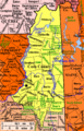
Modern town borders in Coös County, New Hampshire. Cities and towns are named in black and have town records. Green places are unincorporated, and do not keep records.
See also
 In Spanish: Condado de Coös para niños
