
Canaan, New Hampshire facts for kids
Quick facts for kids
Canaan, New Hampshire
|
||
|---|---|---|
|
Town
|
||

Church Street in 1907
|
||
|
||
| Motto(s):
"Land of Milk and Honey"
|
||

Location in Grafton County, New Hampshire
|
||
| Country | United States | |
| State | New Hampshire | |
| County | Grafton | |
| Incorporated | 1761 | |
| Villages |
|
|
| Area | ||
| • Total | 55.1 sq mi (142.8 km2) | |
| • Land | 53.4 sq mi (138.2 km2) | |
| • Water | 1.8 sq mi (4.6 km2) 3.20% | |
| Elevation | 945 ft (288 m) | |
| Population
(2020)
|
||
| • Total | 3,794 | |
| • Density | 71/sq mi (27.5/km2) | |
| Time zone | UTC−5 (Eastern) | |
| • Summer (DST) | UTC−4 (Eastern) | |
| ZIP code |
03741
|
|
| Area code(s) | 603 | |
| FIPS code | 33-08980 | |
| GNIS feature ID | 0873557 | |

Canaan is a town in Grafton County, New Hampshire, in the United States. In 2020, about 3,794 people lived here. It's known for Mascoma State Forest.
Canaan is also home to the Cardigan Mountain School. This school is the town's biggest employer. The main part of town, called the Canaan census-designated place, is where U.S. Route 4 and New Hampshire Route 118 meet.
Contents
History of Canaan
Canaan was officially started in 1761 by Governor Benning Wentworth. It was named after Canaan, Connecticut, where many early settlers came from. That town was named by Puritans after a place in the Bible.
The first settler, John Scofield, arrived in the winter of 1766–1767. He brought all his things on a hand sled. The land had many rocks, which made farming hard. The town built a wide main street on a flat area.
Noyes Academy and the Underground Railroad
In 1828, a lawyer named George Kimball helped build the town's Congregational church. In 1835, he and other abolitionists started Noyes Academy. This was one of the first schools in the area to welcome students of all races.
It opened with 28 white students and 17 black students. Many local people did not like the idea of black students coming to town. On August 10, 1835, a large group of people from Canaan and nearby towns moved the school building off its foundation and then burned it. The black students and Kimball left town for their safety.
Later, the Canaan Union Academy was built on the same spot. This school only allowed white students and operated for 20 years. After it closed, some residents helped fugitive slaves. They used the town as a stop on the Underground Railroad, helping people reach Canada or settle in New England.
Growth and Challenges
The Northern Railroad came to Canaan in 1847. This helped the town grow. Water powered mills were built along the streams. By 1859, the town had 1,682 people. It had mills for grinding grain, making wood products, and tanning leather.
Canaan was the site of a serious train wreck on September 15, 1907. Four miles west of Canaan Station, a passenger train crashed head-on with a freight train. Many people were injured, and 25 people died. This accident happened because of a mistake in the train's orders.

On June 2, 1923, a big fire, known as the Great Canaan Fire, destroyed 48 homes and businesses. It burned down the center of Canaan Village.
Geography and Nature
Canaan covers about 142.8 square kilometers (55.1 square miles). Most of this is land, with about 4.6 square kilometers (1.8 square miles) being water. The town is drained by the Mascoma River and the Indian River. These rivers flow past Canaan village.
Canaan Street Lake is in the middle of town, and Goose Pond is in the northwest.
Mount Cardigan is to the east of Canaan village, in the nearby town of Orange. You can take a mountain road from Canaan to a hiking trail in Cardigan Mountain State Forest. From there, trails lead to the top of the mountain, which is about 3,155 feet high. The highest point in Canaan itself is an unnamed ridge in the northeast, about 2,270 feet above sea level.
Most of Canaan is in the Connecticut River watershed. This means its water flows into the Connecticut River. A small part in the northeast drains into the Baker River, which is part of the Merrimack River watershed.
U.S. Route 4 and New Hampshire Route 118 are the main roads that go through Canaan.
Population and People
Canaan's population has grown over the years. Here's how it has changed:
| Historical population | |||
|---|---|---|---|
| Census | Pop. | %± | |
| 1790 | 483 | — | |
| 1800 | 835 | 72.9% | |
| 1810 | 1,094 | 31.0% | |
| 1820 | 1,198 | 9.5% | |
| 1830 | 1,428 | 19.2% | |
| 1840 | 1,576 | 10.4% | |
| 1850 | 1,682 | 6.7% | |
| 1860 | 1,762 | 4.8% | |
| 1870 | 1,877 | 6.5% | |
| 1880 | 1,762 | −6.1% | |
| 1890 | 1,417 | −19.6% | |
| 1900 | 1,444 | 1.9% | |
| 1910 | 1,408 | −2.5% | |
| 1920 | 1,236 | −12.2% | |
| 1930 | 1,301 | 5.3% | |
| 1940 | 1,377 | 5.8% | |
| 1950 | 1,465 | 6.4% | |
| 1960 | 1,507 | 2.9% | |
| 1970 | 1,923 | 27.6% | |
| 1980 | 2,456 | 27.7% | |
| 1990 | 3,045 | 24.0% | |
| 2000 | 3,319 | 9.0% | |
| 2010 | 3,909 | 17.8% | |
| 2020 | 3,794 | −2.9% | |
| U.S. Decennial Census | |||
In 2010, there were 3,909 people living in Canaan. Most residents were White. A small percentage were Asian, African American, or Native American. About 0.8% of the population was Hispanic or Latino.
About 28.7% of households had children under 18. The average household had 2.42 people. The median age in town was 42.6 years.
Places to Visit
- Canaan Historical Museum: Learn about the town's past.
- Canaan Motor Club: An auto racetrack for racing fans.
- Northern Rail Trail: A great place for walking, biking, or running.
Notable People from Canaan
- Gavin Bayreuther (born 1994), an NHL hockey player.
- Daniel Blaisdell (1762–1833), who served in the U.S. Congress.
- Henry G. Burleigh (1832–1900), a U.S. Congressman from New York.
- Frank Dunklee Currier (1853–1921), another U.S. Congressman.
- Joshua Smith (1760–1795), an author who wrote Divine Hymns, or Spiritual Songs.
- Anna Augusta Truitt (1837–1920), a kind person who helped others and worked for temperance.
Images for kids
-
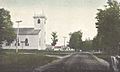
Old North Church around 1915
-
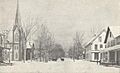
Canaan Village around 1915, before the big fire
-
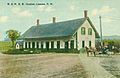
The B. & M. R. R. depot in 1911
-
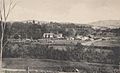
A view of the Canaan Fair around 1906


See also
 In Spanish: Canaan (Nuevo Hampshire) para niños
