
Goose Pond (New Hampshire) facts for kids
Quick facts for kids Goose Pond |
|
|---|---|
 |
|

Goose
Pond Location in New Hampshire

Goose
Pond Location in the United States
|
|
| Location | Grafton County, New Hampshire |
| Coordinates | 43°42′9″N 72°5′38″W / 43.70250°N 72.09389°W |
| Primary inflows | Pressey Brook Marshall Brook |
| Primary outflows | Goose Pond Brook |
| Basin countries | United States |
| Max. length | 2.9 mi (4.7 km) |
| Max. width | 0.6 mi (0.97 km) |
| Surface area | 625 acres (2.5 km2) |
| Average depth | 10 ft (3.0 m) |
| Max. depth | 35 ft (11 m) |
| Surface elevation | 823 ft (251 m) |
| Settlements | Canaan; Hanover |
Goose Pond is a large body of water in New Hampshire, United States. It covers about 625-acre (2.5 km2) of land. You can find it in Grafton County, partly in the town of Canaan and partly in Hanover. Most of the pond is in Canaan.
The pond is considered a "great pond" by the state of New Hampshire. This means it is a large natural body of water that the public can use. Goose Pond has about 6.3 miles (10.1 km) of shoreline. It is about 3 miles (5 km) long and 0.5 miles (0.8 km) wide. The pond is usually about 10 feet (3.0 m) deep, but its deepest spot is around 35 feet (11 m). Water from Goose Pond flows into the Mascoma River and then into the Connecticut River. This whole area is part of the Mascoma River's watershed, which is the land area that drains water into a river or lake.
Contents
The Story Behind Goose Pond's Name
People have known about Goose Pond since the late 1700s. There's a fun legend about how it got its name.
The Tough Goose Legend
In 1767, a group led by George Harris was exploring near Hanover. They found a pond that seemed to be covered with wild geese and ducks. They decided to catch a goose for dinner. But this goose was very old and tough! No matter how long they cooked it, it never became tender. To remember this funny event, they named the water "Goose Pond."
The Goose Pond Dam
A small wooden dam was built on Goose Pond in 1899. This dam likely made the pond bigger than it was before.
How the Dam Was Built and Used
The dam we see today was built between 1917 and 1918. It has been repaired a few times since then, in 1952 and 1990. The dam was important for the mills in Lebanon. It helped store water that could be used to create power for these mills and for hydroelectric plants. Hydroelectric plants use the force of moving water to make electricity.
Today, New Hampshire Water Resources manages the dam. They still sell water power once a year by lowering the water level a bit. The money they earn helps pay for the dam's upkeep. Goose Pond is still a very important place for fun activities, beautiful views, and the environment in the Mascoma River area.
Islands and Public Access
Goose Pond has two islands. People call them "The Big Island" and "The Little Island."
Places to Visit at Goose Pond
There is one public boat launch area on the pond, which is owned by the state. It's known as "The Acre." At The Acre, you'll find a small public beach. There's another small beach near the dam at the southern end of the pond.
If you visit The Acre, the dam area, or either of the islands, remember that you cannot camp overnight or have fires. Fires are only allowed on private property if you have a free permit from the fire warden.
Homes Around the Pond
There are about 160 cottages or homes right on the pond or across the road from it. More than 30 of these homes are used by people who live there all year round. Most of the shoreline around the pond is owned by the state, but some parts are privately owned.
Wildlife at Goose Pond
Goose Pond is home to many different kinds of animals. You can see and hear them throughout the year.
Animals on Land
You might spot large animals like moose, bears, and deer. Wild turkeys, foxes, and coyotes also live nearby.
Animals in and Near the Water
Closer to the water, you might see otters, beavers, and minks. Turtles are often seen swimming in the pond.
Birds of Goose Pond
The pond has a wide variety of birds. Look for ospreys, eagles, and great blue herons. You might also see plovers, kingfishers, Canada geese, different types of ducks, and loons.
Fish in Goose Pond
Goose Pond is known as a "warm water fishery." This means it's a good place to catch fish that prefer warmer water.
Types of Fish You Can Catch
Some of the fish found in Goose Pond include smallmouth bass, largemouth bass, chain pickerel, horned pout, and white perch.
A very famous fish was caught here! In August 1970, Francis H. Loud caught the state record smallmouth bass in Goose Pond. It weighed an amazing 7 pounds and 14.5 ounces!
Images for kids
-
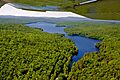
Aerial view of Goose Pond

