Ellsworth, New Hampshire facts for kids
Quick facts for kids
Ellsworth, New Hampshire
|
|
|---|---|
|
Town
|
|

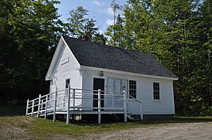
Town hall
|
|

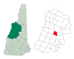
Location in Grafton County, New Hampshire
|
|
| Country | United States |
| State | New Hampshire |
| County | Grafton |
| Incorporated | 1769 |
| Area | |
| • Total | 21.5 sq mi (55.8 km2) |
| • Land | 21.4 sq mi (55.5 km2) |
| • Water | 0.1 sq mi (0.3 km2) 0.58% |
| Elevation | 1,174 ft (358 m) |
| Population
(2020)
|
|
| • Total | 93 |
| • Density | 4/sq mi (1.7/km2) |
| Time zone | UTC-5 (Eastern) |
| • Summer (DST) | UTC-4 (Eastern) |
| ZIP codes | |
| Area code(s) | 603 |
| FIPS code | 33-23860 |
| GNIS feature ID | 0873589 |
Ellsworth is a small town located in Grafton County, New Hampshire, United States. In 2020, about 93 people lived there.
History of Ellsworth
Ellsworth was first known as "Trecothick." This name came from Barlow Trecothick. He was a businessman from Boston who later moved to London. In London, he became an important leader. He was an alderman (a city council member) and a Member of Parliament (MP). He even served as the Lord Mayor of the City of London, which is like being the mayor of a very big city.
The town's name was changed to "Ellsworth" in 1802. This new name honored Oliver Ellsworth. He was a very important judge, serving as the Chief Justice of the United States.
The first time people counted how many residents lived in Ellsworth was in 1800. At that time, only 47 people called Ellsworth home.
Geography and Nature
Ellsworth covers an area of about 55.8 square kilometers (about 21.5 square miles). Most of this area is land, with only a small part being water.
The town has several small streams. Hubbard Brook flows through the northern part of town. West Branch Brook is in the south. A small part of the southwest is drained by Sucker Brook, which flows into Stinson Lake in a nearby town called Rumney. All these streams eventually flow into the Pemigewasset River. This means Ellsworth is part of the larger Merrimack River watershed. A watershed is an area of land where all the water drains into a single river or lake.
The highest point in Ellsworth is the top of Mount Kineo. It stands tall at about 1,009 meters (3,313 feet) above sea level. The entire town of Ellsworth is located within the beautiful White Mountain National Forest. This forest is a protected area with lots of trees and wildlife. Even though it's mostly forest, there are still some private properties within the town.
The Hubbard Brook Experimental Forest is also found in the northern part of Ellsworth. This special forest is used by scientists to study how nature works, especially forests and water.
Population Changes Over Time
Ellsworth has always been a small town, and its population has changed quite a bit over the years. Here's a look at how many people have lived there during different census counts:
| Historical population | |||
|---|---|---|---|
| Census | Pop. | %± | |
| 1800 | 47 | — | |
| 1810 | 142 | 202.1% | |
| 1820 | 213 | 50.0% | |
| 1830 | 234 | 9.9% | |
| 1840 | 300 | 28.2% | |
| 1850 | 320 | 6.7% | |
| 1860 | 302 | −5.6% | |
| 1870 | 193 | −36.1% | |
| 1880 | 209 | 8.3% | |
| 1890 | 150 | −28.2% | |
| 1900 | 107 | −28.7% | |
| 1910 | 46 | −57.0% | |
| 1920 | 30 | −34.8% | |
| 1930 | 28 | −6.7% | |
| 1940 | 26 | −7.1% | |
| 1950 | 24 | −7.7% | |
| 1960 | 3 | −87.5% | |
| 1970 | 13 | 333.3% | |
| 1980 | 53 | 307.7% | |
| 1990 | 74 | 39.6% | |
| 2000 | 87 | 17.6% | |
| 2010 | 83 | −4.6% | |
| 2020 | 93 | 12.0% | |
| U.S. Decennial Census | |||
In 2000, there were 87 people living in Ellsworth. These people lived in 32 different homes. About 34% of these homes had children under 18 living there. Most of the people living in Ellsworth were White.
The average age of people in Ellsworth in 2000 was 41 years old. About 29.9% of the population was under 18. This shows that Ellsworth is a quiet place with a mix of families and older residents.
See also
 In Spanish: Ellsworth (Nuevo Hampshire) para niños
 | Georgia Louise Harris Brown |
 | Julian Abele |
 | Norma Merrick Sklarek |
 | William Sidney Pittman |

