Lyman, New Hampshire facts for kids
Quick facts for kids
Lyman, New Hampshire
|
|
|---|---|
|
Town
|
|

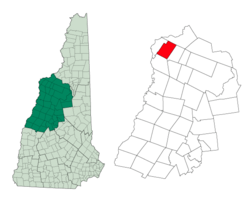
Location in Grafton County, New Hampshire
|
|
| Country | United States |
| State | New Hampshire |
| County | Grafton |
| Incorporated | 1761 |
| Villages |
|
| Area | |
| • Total | 28.7 sq mi (74.3 km2) |
| • Land | 28.4 sq mi (73.5 km2) |
| • Water | 0.3 sq mi (0.8 km2) 1.03% |
| Elevation | 1,220 ft (370 m) |
| Population
(2020)
|
|
| • Total | 585 |
| • Density | 21/sq mi (8.0/km2) |
| Time zone | UTC-5 (Eastern) |
| • Summer (DST) | UTC-4 (Eastern) |
| ZIP code |
03585
|
| Area code(s) | 603 |
| FIPS code | 33-44100 |
| GNIS feature ID | 0873653 |
Lyman is a small and quiet town located in Grafton County, New Hampshire, United States. In 2020, about 585 people lived there. It's a place with a lot of history and natural beauty.
Contents
History of Lyman
Lyman was first established a long time ago, in 1761. It was named after General Phineas Lyman. He was an important commander during the French and Indian War. The town was given to him and 63 other people as a reward for their service.
Early Beginnings
The first group of people who received the land didn't follow all the rules at first. But they were given more time to meet the requirements in 1769. This allowed the town to officially begin.
Town Changes Over Time
For many years, Lyman included the land that is now the town of Monroe, New Hampshire. But traveling between the two parts was hard because of Gardner Mountain. So, in 1854, the western part of Lyman became its own town, Monroe. In 1880, Lyman had a population of 665 people.
Geography of Lyman
Lyman is a town with a total area of about 74.3 square kilometers (28.7 square miles). Most of this area, about 73.5 square kilometers (28.4 square miles), is land. The rest, 0.8 square kilometers (0.3 square miles), is water.
Waterways and Mountains
The town has many small streams and rivers. These waters flow into the Ammonoosuc River. The Ammonoosuc River eventually joins the larger Connecticut River. This whole area is part of the Connecticut River watershed. A watershed is an area of land where all the water drains into a single river system.
The highest point in Lyman is about 2,285 feet (696 meters) above sea level. This spot is near the top of Signal Mountain. Signal Mountain is part of the Gardner Mountain ridge. This mountain ridge forms the western edge of the town.
People of Lyman
The number of people living in Lyman has changed a lot over the years. Here's a look at how the population has grown and shrunk:
| Historical population | |||
|---|---|---|---|
| Census | Pop. | %± | |
| 1790 | 202 | — | |
| 1800 | 534 | 164.4% | |
| 1810 | 948 | 77.5% | |
| 1820 | 1,270 | 34.0% | |
| 1830 | 1,321 | 4.0% | |
| 1840 | 1,496 | 13.2% | |
| 1850 | 1,442 | −3.6% | |
| 1860 | 743 | −48.5% | |
| 1870 | 658 | −11.4% | |
| 1880 | 654 | −0.6% | |
| 1890 | 543 | −17.0% | |
| 1900 | 426 | −21.5% | |
| 1910 | 374 | −12.2% | |
| 1920 | 310 | −17.1% | |
| 1930 | 299 | −3.5% | |
| 1940 | 363 | 21.4% | |
| 1950 | 241 | −33.6% | |
| 1960 | 201 | −16.6% | |
| 1970 | 213 | 6.0% | |
| 1980 | 281 | 31.9% | |
| 1990 | 388 | 38.1% | |
| 2000 | 487 | 25.5% | |
| 2010 | 533 | 9.4% | |
| 2020 | 585 | 9.8% | |
| U.S. Decennial Census | |||
Population in 2000
According to the census from 2000, there were 487 people living in Lyman. These people made up 211 households and 150 families. Most of the people living in Lyman were White.
About a quarter of the households had children under 18 living there. Most households were married couples living together. The average household had about 2.31 people.
Age Groups
The population in 2000 was spread out across different age groups. About 19.9% of the people were under 18 years old. About 32.0% were between 25 and 44 years old. And 11.9% were 65 years old or older. The average age in Lyman was 42 years.
See also
 In Spanish: Lyman (Nuevo Hampshire) para niños
 | Percy Lavon Julian |
 | Katherine Johnson |
 | George Washington Carver |
 | Annie Easley |

