Montcalm, New Hampshire facts for kids
Quick facts for kids
Montcalm, New Hampshire
|
|
|---|---|

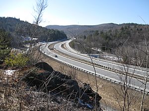
Exit 15 (Montcalm) on Interstate 89
|
|
| Country | United States |
| State | New Hampshire |
| County | Grafton |
| Town | Enfield |
| Elevation | 1,211 ft (369 m) |
| Time zone | UTC-5 (Eastern (EST)) |
| • Summer (DST) | UTC-4 (EDT) |
| Area code(s) | 603 |
| GNIS feature ID | 1917586 |
Montcalm is a small place in the town of Enfield, which is in Grafton County, New Hampshire, United States. It's called an "unincorporated community" because it doesn't have its own local government like a city or town. Instead, it's part of the larger town of Enfield.
Montcalm is found along an old part of New Hampshire Route 10. This old road exists because most of Route 10 was replaced by a bigger highway called Interstate 89. You can only get to this old part of the road from Exit 15 on Interstate 89. If you try to go further down the old road in either direction from the exit, you'll find it ends. Today, the main Route 10 actually runs right alongside Interstate 89 in this area. Montcalm is about 1,211 feet (369 meters) above sea level.
Why is it Called Montcalm?
The name "Montcalm" was chosen in 1960 by the leaders of Enfield, called "selectmen." They picked this name when the plans for building Interstate 89 were being made. State highway engineers had first suggested the name "South Notch," but the selectmen wanted something different.
"Montcalm" was actually the name of an older settlement that used to be in this area. That old settlement even had its own post office and a school. So, the name was chosen to remember the history of the place.
 | Bessie Coleman |
 | Spann Watson |
 | Jill E. Brown |
 | Sherman W. White |


