Liberty Mills, Indiana facts for kids
Quick facts for kids
Liberty Mills, Indiana
|
|
|---|---|
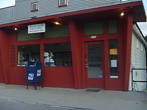
Post Office, Downtown Liberty Mills
|
|
| Country | United States |
| State | Indiana |
| County | Wabash |
| Township | Chester |
| Platted | September 5, 1837 |
| Elevation | 781 ft (238 m) |
| Population
(2010)
|
|
| • Total | 136 |
| Time zone | UTC-5 (Eastern (EST)) |
| • Summer (DST) | UTC-4 (EDT) |
| ZIP code |
46946
|
| FIPS code | 18-43596 |
| GNIS feature ID | 2830570 |
Liberty Mills is a small community located in Wabash County, Indiana, right by the Eel River. It's called an "unincorporated community," which means it's not officially a city or town with its own government.
The community was planned by John Comstock in 1837. Its name, Liberty Mills, comes from the many mills that used to operate there. These included a saw mill, a carding mill (for processing wool), and even a distillery. One of the mills was named 'Liberty,' which also contributed to the town's name. The ZIP code for Liberty Mills is 46946.
People in Liberty Mills
This section shares information about the people living in Liberty Mills. In 2010, about 136 people lived in the area.
There were 47 households, and 37 of these were families. About 32% of households had kids under 18 living with them. Most households (66%) were married couples.
The people in Liberty Mills were of different ages. About 31% were under 19 years old. About 15% were 65 years or older. The average age in the community was around 32.7 years old.
History of Liberty Mills
The land where Liberty Mills now stands has a long history. In 1826, the Potawatomi and Miami Native American tribes signed peace treaties with the United States government. These treaties opened up lands north of the Wabash River for new settlers.
These important talks were led by Michigan Governor Lewis Cass. They resulted in what is known as the Paradise Springs Peace Treaty. Before this, the Potawatomi people lived along the Eel River. They called it the Kenapocomoco. Their villages were near where North Manchester is today, just a few miles south of Liberty Mills.
Early Settlers and Mills
The land that became Liberty Mills was first bought by James Abbott. He was involved in the treaty talks. Later, a man named Mr. McBride bought it, planning to build a grist mill (for grinding grain).
Eventually, a man named John Comstock from New York bought the land. He moved to the area in 1836. John Comstock quickly started building businesses. He first built a saw mill, which cuts wood. Then he added a grist mill, a store, a carding mill, and a flouring mill.
John Comstock was a very important businessman and farmer in the area. He was even a member of the state government and a judge. He was known for being very progressive but also very stubborn.
Comstock built a distillery in 1839. This made whiskey that was sent to towns far away. However, his sons, who had strong religious beliefs, did not want to be part of the distillery business. Eventually, Comstock himself decided to stop making whiskey.
Growth of Neighboring Towns
Because John Comstock was so good at business, he sometimes made it hard for others to compete. This led many local business people to move to nearby North Manchester. Over time, North Manchester grew much larger, while Liberty Mills stayed about the same size.
However, Comstock was important in bringing the Detroit, Eel River & Illinois Railroad through Liberty Mills in 1871. This railroad connected different towns. Over the years, the railroad's use decreased, and it was eventually stopped between 1954 and 1977.
Liberty Mills Bridges
Because Liberty Mills is located on a winding part of the Eel River, it has always needed many bridges. Today, three bridges still stand.
The Covered Bridge
At the spot where an iron bridge is today, there used to be a famous covered bridge. Three different covered bridges were built here over the years. The first was built in 1859 and lasted until 1867. The second was built in 1867 and stood until 1872. It was 192 feet long.
The third and most well-known covered bridge was built in 1872 by the Smith Bridge Company. It was a beautiful wooden bridge with a roof. This bridge was even mentioned in Time magazine in 1936. It was the only time Liberty Mills received national attention. Sadly, this bridge was lost in 1953.
The Eel River Dam
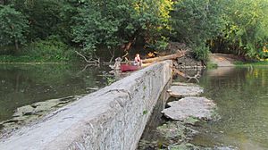
Liberty Mills also had a dam on the Eel River. It was a "crib dam," which means it was made of timber frames filled with rocks. It was built in the 1800s to power the many mills in town.
By the early 2000s, the dam was no longer in use and was damaged. In 2012, the dam was removed. This was done to help fish move more easily along the river. Removing the dam also helped improve the overall health of the Wabash River watershed.
The School House
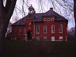
The largest building in Liberty Mills is its old school house, built in 1903. The first children in the community were taught in a log cabin. Later, a proper school building was built in 1841.
In 1872, a two-story building was constructed to be both a school and a town hall. This building was taken down in 1903, and a new school was built on the same foundation. The school stopped operating in the 1950s. It was later fixed up in 1989 and is now a rented home.
Nature and Outdoors
Even though Liberty Mills is a small community, it has several special places for nature. These include nature preserves and areas for outdoor activities.
These preserves are managed by the Tippecanoe Audubon Society. This is a local group that is part of the national Audubon Society, which works to protect birds and their habitats. There is also an Izaak Walton League club ground and a public access site to the river.
Taylor Preserve
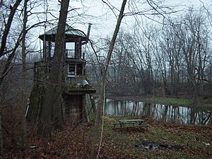
The Herbert L. Taylor Audubon Preserve is on the northeast side of town, along the Eel River. The Taylor family owned this land for many generations. In 1990, Herbert "Herb" Taylor donated the remaining property to the Audubon Society.
Herb Taylor built a very unique three-story house on the preserve. It was shaped like a Native American teepee and overlooked the Eel River. This special "Tee-Pee" building was unfortunately taken down in 2003 due to damage.
Flory-Gemmer Marsh and Woods Preserve
The Flory-Gemmer Marsh Preserve and Woods Preserve are two smaller nature areas. They are located about a mile east of Liberty Mills. These lands were also donated to the Tippecanoe Audubon Society in the mid-1990s.
Izaak Walton League Club Grounds
North of Liberty Mills, you'll find the club grounds for the Izaak Walton League. This group focuses on conserving natural resources. At their grounds, people can enjoy fishing and shooting sports. They often hold turkey shoot tournaments there.
Public Access to Eel River
On the south side of town, there is a public access site to the Eel River. This part of the Eel River is very popular for canoeing. It is even mentioned in several canoeing guidebooks.
Notable Person
Cliff Kindy is an organic farmer who lives near Liberty Mills. He is also a member of the Christian Peacemaker Teams (CPT). CPT is a group that works for peace in places around the world. Cliff Kindy has traveled with CPT to many countries, including Iraq. He was even mentioned in New Yorker Magazine in 2004 for his work.
 | Emma Amos |
 | Edward Mitchell Bannister |
 | Larry D. Alexander |
 | Ernie Barnes |


