Wells County, Indiana facts for kids
Quick facts for kids
Wells County
|
|
|---|---|

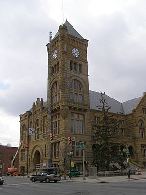
Wells County Courthouse in Bluffton
|
|

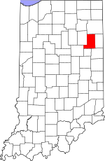
Location within the U.S. state of Indiana
|
|
 Indiana's location within the U.S. |
|
| Country | |
| State | |
| Founded | 1837 |
| Named for | William A. Wells |
| Seat | Bluffton |
| Largest city | Bluffton |
| Area | |
| • Total | 370.25 sq mi (958.9 km2) |
| • Land | 368.09 sq mi (953.3 km2) |
| • Water | 2.16 sq mi (5.6 km2) 0.58%% |
| Population
(2020)
|
|
| • Total | 28,180 |
| • Estimate
(2023)
|
28,555 |
| • Density | 76.111/sq mi (29.387/km2) |
| Time zone | UTC−5 (Eastern) |
| • Summer (DST) | UTC−4 (EDT) |
| Congressional district | 3rd |
| Indiana county number 90 | |
Wells County is a county located in the state of Indiana, in the United States. In 2020, about 28,180 people lived here. The main town and center of government for Wells County is Bluffton. Wells County is part of the larger Fort Wayne Metropolitan Statistical Area, which includes several nearby cities and towns.
Contents
History of Wells County
The area that is now Indiana became the Indiana Territory in 1800. This happened because of a law called the Northwest Ordinance of 1787. As more people moved into the territory, new counties were created.
In December 1816, Indiana officially became a state in the United States. Wells County was named after William A. Wells. He was a famous frontiersman who was important during the Northwest Indian Wars. He was also involved with places like Fort Miami and Kekionga.
At first, Wells County was managed by Allen County. But in 1835, a new law was passed to create more counties in northern Indiana. Wells County was one of these new counties.
On February 2, 1837, another law allowed Wells County to become independent from Allen County. The first meeting to organize the county was supposed to happen on May 1, 1837, but it didn't. So, on January 20, 1838, a new law set up a meeting for commissioners. They met on March 5, 1838, and chose Bluffton as the county seat.
Geography of Wells County
Wells County has gentle, rolling hills. Most of the forests have been cleared for farms and towns. The Wabash River flows through the northern and central parts of the county. The Salamonie River drains the southern part. Both rivers flow towards the northwest.
The highest point in the county is about 935 feet (285 meters) above sea level. This spot is on the southern border with Jay County.
In 2010, the county covered a total area of 370.25 square miles (959.0 km²). About 368.09 square miles (953.3 km²) of this is land, and 2.16 square miles (5.6 km²) is water. This means only a small part (0.58%) is water.
Neighboring Counties
- Allen County - north
- Adams County - east
- Jay County - southeast
- Blackford County - south
- Grant County - west
- Huntington County - northwest
Cities and Towns in Wells County
- Bluffton (city and county seat)
- Markle (town; partly in Huntington County)
- Ossian (town)
- Poneto (town - was called Worthington from 1871 to 1881)
- Uniondale (town)
- Vera Cruz (town)
- Zanesville (town; partly in Allen County)
Smaller Communities in Wells County
Townships in Wells County
- Chester
- Harrison
- Jackson
- Jefferson
- Lancaster
- Liberty
- Nottingham
- Rockcreek
- Union
Main Roads in Wells County
Climate and Weather in Wells County
| Weather chart for Bluffton, Indiana | |||||||||||||||||||||||||||||||||||||||||||||||
|---|---|---|---|---|---|---|---|---|---|---|---|---|---|---|---|---|---|---|---|---|---|---|---|---|---|---|---|---|---|---|---|---|---|---|---|---|---|---|---|---|---|---|---|---|---|---|---|
| J | F | M | A | M | J | J | A | S | O | N | D | ||||||||||||||||||||||||||||||||||||
|
2
30
16
|
1.8
34
19
|
2.6
46
29
|
3.2
58
40
|
4.1
70
51
|
3.9
80
61
|
3.9
84
64
|
3.7
81
62
|
3.1
75
55
|
2.5
63
42
|
3
48
33
|
2.7
35
23
|
||||||||||||||||||||||||||||||||||||
| temperatures in °F precipitation totals in inches source: The Weather Channel |
|||||||||||||||||||||||||||||||||||||||||||||||
|
Metric conversion
|
|||||||||||||||||||||||||||||||||||||||||||||||
In Bluffton, the average temperatures change throughout the year. In January, the average low is 16°F (-9°C). In July, the average high is 84°F (29°C). The coldest temperature ever recorded was -24°F (-31°C) in January 1985. The hottest was 104°F (40°C) in July 1980.
The amount of rain and snow also changes. February usually has the least precipitation, with about 1.83 inches (4.6 cm). May typically has the most, with about 4.11 inches (10.4 cm).
Population of Wells County
| Historical population | |||
|---|---|---|---|
| Census | Pop. | %± | |
| 1840 | 1,822 | — | |
| 1850 | 6,152 | 237.7% | |
| 1860 | 10,844 | 76.3% | |
| 1870 | 13,585 | 25.3% | |
| 1880 | 18,442 | 35.8% | |
| 1890 | 21,514 | 16.7% | |
| 1900 | 23,449 | 9.0% | |
| 1910 | 22,418 | −4.4% | |
| 1920 | 20,509 | −8.5% | |
| 1930 | 18,411 | −10.2% | |
| 1940 | 19,099 | 3.7% | |
| 1950 | 19,564 | 2.4% | |
| 1960 | 21,220 | 8.5% | |
| 1970 | 23,821 | 12.3% | |
| 1980 | 25,401 | 6.6% | |
| 1990 | 25,948 | 2.2% | |
| 2000 | 27,600 | 6.4% | |
| 2010 | 27,636 | 0.1% | |
| 2020 | 28,180 | 2.0% | |
| 2023 (est.) | 28,555 | 3.3% | |
| US Decennial Census 1790-1960 1900-1990 1990-2000 2010-2013 2018 2020 |
|||
2010 Census Information
According to the 2010 United States Census, Wells County had 27,636 people living there. There were 10,780 households, and 7,684 families. The population density was about 75 people per square mile (29 people/km²).
Most people in the county were white (97.3%). About 2.0% of the population was of Hispanic or Latino background. Many people had German (38.4%), English (12.3%), or Irish (10.8%) ancestry.
Of the households, 33.1% had children under 18 living with them. About 58.1% were married couples. The average household had 2.52 people, and the average family had 3.00 people. The average age of people in the county was 40.2 years old.
The median income for a household was $47,697. For a family, it was $56,885. About 8.0% of all people in the county lived below the poverty line. This included 10.8% of those under 18 and 3.6% of those aged 65 or older.
Education in Wells County
Students in Wells County attend schools in several different districts. These include the Bluffton-Harrison Metropolitan School District, Northern Wells Community Schools, and Southern Wells Community Schools.
See also
 In Spanish: Condado de Wells (Indiana) para niños
 | Aurelia Browder |
 | Nannie Helen Burroughs |
 | Michelle Alexander |

