Northwood, Ohio facts for kids
Quick facts for kids
Northwood, Ohio
|
|||
|---|---|---|---|
|
|||
| Motto(s):
"Where Opportunity Abounds"
|
|||

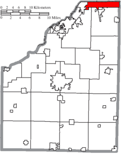
Location of Northwood in Wood County
|
|||
| Country | United States | ||
| State | Ohio | ||
| County | Wood | ||
| Area | |||
| • Total | 8.57 sq mi (22.20 km2) | ||
| • Land | 8.56 sq mi (22.16 km2) | ||
| • Water | 0.01 sq mi (0.03 km2) | ||
| Elevation | 614 ft (187 m) | ||
| Population
(2020)
|
|||
| • Total | 5,160 | ||
| • Density | 603.02/sq mi (232.82/km2) | ||
| Time zone | UTC-5 (Eastern (EST)) | ||
| • Summer (DST) | UTC-4 (EDT) | ||
| ZIP code |
43619
|
||
| Area code(s) | 419 | ||
| FIPS code | 39-57190 | ||
| GNIS feature ID | 1087191 | ||
| Website | http://www.ci.northwood.oh.us/ | ||
Northwood is a city located in Wood County, Ohio, in the United States. It is an eastern suburb of the Toledo metropolitan area. In 2020, about 5,160 people lived in Northwood.
Contents
History of Northwood
Northwood started as Ross Township. A "township" is a type of local government area. It was the northernmost township in Wood County. Ross Township was created on April 18, 1874.
For many years, the area was mostly farms, gardens, and orchards. Railroads also ran through the area. In 1898, a glass factory was built by Edward Ford along the Maumee River. This factory helped the nearby village of Rossford grow.
Ross Township was later divided. On December 1, 1962, Ross Township officially became the city of Northwood. It was named "Northwood" because it is located at the northern part of Wood County. When Northwood became a city, Wood County went from having 20 townships to 19.
Geography of Northwood
Northwood covers a total area of about 8.53 square miles (22.09 square kilometers). Most of this area is land, with only a small part being water.
Neighboring Towns and Areas
Northwood shares borders with several other cities and townships:
- Rossford - to the West
- Perrysburg Township - to the South-West
- Lake Township - to the South
- Toledo - to the North
- Ottawa County (Curtice) - to the East
- Oregon - to the North-East
- Walbridge - to the South
Population and People of Northwood
Northwood has seen its population change over the years. Here's a quick look at how many people have lived there:
| Historical population | |||
|---|---|---|---|
| Census | Pop. | %± | |
| 1970 | 4,222 | — | |
| 1980 | 5,495 | 30.2% | |
| 1990 | 5,506 | 0.2% | |
| 2000 | 5,471 | −0.6% | |
| 2010 | 5,265 | −3.8% | |
| 2020 | 5,160 | −2.0% | |
| 2021 (est.) | 5,179 | −1.6% | |
| Sources: | |||
Northwood in 2010
In 2010, there were 5,265 people living in Northwood. There were 2,025 households, which means groups of people living together. About 33% of these households had children under 18. Most households (55%) were married couples. The average household had about 2.6 people.
The average age of people in Northwood was 39 years old. About 24% of residents were under 18, and 11.5% were 65 or older. The population was almost evenly split between males (49%) and females (51%).
Education in Northwood
Northwood has its own schools for students from kindergarten through high school.
Schools in Northwood
The main schools in Northwood are:
- Northwood High School: This school serves students in grades 7 through 12.
- Northwood Elementary School: This school is for students from pre-kindergarten (PK) through grade 6.
Both schools are located at 600 Lemoyne Rd, Northwood. Northwood High School is the only high school in the Northwood Local Schools district. The current high school building was built in 2017.
In the 2006–2007 school year, Northwood schools received an "Excellent" rating from the state of Ohio for their education quality. The graduation rate was high, with 90.5% of students graduating. The attendance rate was also good, at 95.9%. This means most students were in school regularly.
See also
 In Spanish: Northwood (Ohio) para niños
 | Leon Lynch |
 | Milton P. Webster |
 | Ferdinand Smith |


