Kenton County, Kentucky facts for kids
Quick facts for kids
Kenton County
|
|
|---|---|

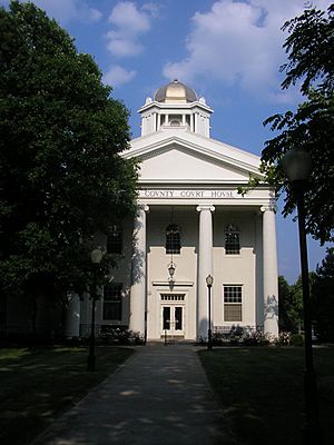
Kenton County Courthouse in Independence
|
|

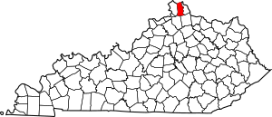
Location within the U.S. state of Kentucky
|
|
 Kentucky's location within the U.S. |
|
| Country | |
| State | |
| Founded | 1840 |
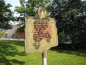
| Named for | Simon Kenton |
| Seat | Covington and Independence |
| Largest city | Covington |
| Area | |
| • Total | 164 sq mi (420 km2) |
| • Land | 160 sq mi (400 km2) |
| • Water | 4.1 sq mi (11 km2) 2.5% |
| Population
(2020)
|
|
| • Total | 169,064 |
| • Estimate
(2023)
|
171,321 |
| • Density | 1,030.9/sq mi (398.0/km2) |
| Time zone | UTC−5 (Eastern) |
| • Summer (DST) | UTC−4 (EDT) |
| Congressional district | 4th |
Kenton County is a county located in the northern part of Kentucky. It's part of the Northern Kentucky area. In 2020, about 169,064 people lived there. This makes it the third most populated county in Kentucky.
Kenton County has two main administrative centers, called county seats. These are Covington and Independence. The county was created in 1840. It was named after Simon Kenton, a famous frontiersman from early Kentucky history.
Kenton County is also part of a larger metropolitan area. This includes Boone and Campbell Counties. This whole area is part of the bigger Cincinnati-Middletown, OH-KY-IN Metropolitan Statistical Area.
Contents
History of Kenton County
Kenton County was officially formed on January 29, 1840. The land for the county came from a part of Campbell County. The county was named to honor Simon Kenton. He was an important pioneer who helped explore and settle Kentucky.
Geography and Location
Kenton County covers a total area of about 164 square miles. Most of this (160 square miles) is land. About 4.1 square miles (2.5%) is water. The county is located where the Licking River meets the Ohio River. This area is part of the outer Bluegrass region of Kentucky. The land in the county ranges from about 455 feet to 960 feet above sea level.
Neighboring Counties
Kenton County shares its borders with several other counties:
- Hamilton County, Ohio (to the north)
- Campbell County (to the east)
- Pendleton County (to the southeast)
- Grant County (to the southwest)
- Boone County (to the west)
Major Roads and Highways
Several important highways pass through Kenton County. These roads help people travel easily throughout the area and connect to other states.
Population of Kenton County
| Historical population | |||
|---|---|---|---|
| Census | Pop. | %± | |
| 1850 | 17,038 | — | |
| 1860 | 25,467 | 49.5% | |
| 1870 | 36,096 | 41.7% | |
| 1880 | 43,983 | 21.9% | |
| 1890 | 54,161 | 23.1% | |
| 1900 | 63,591 | 17.4% | |
| 1910 | 70,355 | 10.6% | |
| 1920 | 73,453 | 4.4% | |
| 1930 | 93,534 | 27.3% | |
| 1940 | 93,139 | −0.4% | |
| 1950 | 104,254 | 11.9% | |
| 1960 | 120,700 | 15.8% | |
| 1970 | 129,440 | 7.2% | |
| 1980 | 137,058 | 5.9% | |
| 1990 | 142,031 | 3.6% | |
| 2000 | 151,464 | 6.6% | |
| 2010 | 159,720 | 5.5% | |
| 2020 | 169,064 | 5.9% | |
| 2023 (est.) | 171,321 | 7.3% | |
| U.S. Decennial Census 1790-1960 1900-1990 1990-2000 2010-2020 |
|||
In 2000, there were 151,464 people living in Kenton County. There were about 59,444 households. The average number of people in a household was 2.52. The average family had 3.11 people.
About 33.40% of households had children under 18. About 50.10% were married couples. The median age of people in the county was 34 years old. For every 100 females, there were about 96 males.
Education in Kenton County
Kenton County offers many educational options. These include public and private schools, as well as colleges.
Public Schools
Kenton County has five different public school districts. These districts serve students from rural areas to busy city areas.
- Kenton County School District
- Covington Independent Public Schools
- Beechwood Independent School District (serves Fort Mitchell)
- Ludlow Independent Schools
- Erlanger-Elsmere Schools
Private Schools
The Catholic Church also runs many schools in Kenton County. The Diocese of Covington's Department of Schools operates 17 schools in the county.
Higher Education
For students looking to go to college, Kenton County has a few choices.
- Thomas More University is located completely within the county.
- Northern Kentucky University used to have a campus in Covington. Its main campus is very close by, just about 4 miles from the Licking River.
- The Kentucky Community and Technical College System also has Gateway Community and Technical College. This college offers classes in several locations, including Covington, Park Hills, and Edgewood.
Libraries
Kenton County has a public library system. It has branches in Covington, Erlanger, and Independence. The Erlanger Branch is known for being the busiest library branch in Kentucky. In 2008, the Kenton County Public Library received a high ranking for its services.
Communities in Kenton County
Kenton County is home to many different cities and smaller communities.
Cities
- Bromley
- Covington (one of the county seats)
- Crescent Springs
- Crestview Hills
- Edgewood
- Elsmere
- Erlanger
- Fairview
- Fort Mitchell
- Fort Wright
- Independence (one of the county seats)
- Kenton Vale
- Lakeside Park
- Ludlow
- Park Hills
- Ryland Heights
- Taylor Mill
- Villa Hills
- Walton
Unincorporated Communities
These are smaller communities that are not officially cities.
Note that Visalia and Latonia Lakes used to be cities but are no longer recognized as such within Kenton County.
See also
 In Spanish: Condado de Kenton para niños
 | Mary Eliza Mahoney |
 | Susie King Taylor |
 | Ida Gray |
 | Eliza Ann Grier |


