Independence, Kentucky facts for kids
Quick facts for kids
Independence, Kentucky
|
||
|---|---|---|

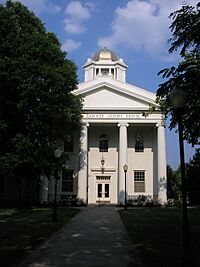
Kenton County Courthouse
|
||
|
||

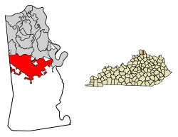
Location in Kenton County, Kentucky
|
||
| Country | United States | |
| State | Kentucky | |
| County | Kenton | |
| Named for | Establishment of Kenton County | |
| Area | ||
| • Total | 17.80 sq mi (46.11 km2) | |
| • Land | 17.56 sq mi (45.49 km2) | |
| • Water | 0.24 sq mi (0.62 km2) | |
| Elevation | 774 ft (236 m) | |
| Population
(2020)
|
||
| • Total | 28,676 | |
| • Estimate
(2022)
|
29,326 | |
| • Density | 1,632.66/sq mi (630.36/km2) | |
| Time zone | UTC−5 (Eastern (EST)) | |
| • Summer (DST) | UTC−4 (EDT) | |
| ZIP code |
41051
|
|
| Area code(s) | 859 | |
| FIPS code | 21-39142 | |
| GNIS feature ID | 2404755 | |
Independence is a city in Kenton County, Kentucky, United States. It's a "home rule-class city," which means it has the power to manage its own local affairs. Independence is one of two places where the county government is located.
In 2020, about 28,676 people lived here. This makes Independence the third-largest city in Northern Kentucky. It is part of the larger Cincinnati metropolitan area.
Contents
History of Independence
The area where Independence is now had a post office as early as 1837. It was first called "Everett's Creek," then "Crews Creek," and later "Bagby."
In 1840, Kenton County was created. It was formed from parts of Campbell and Boone counties. A local farmer named John McCollum gave land for the new county's government center. The name "Independence" was chosen to celebrate the freedom of people from Campbell County. The post office was renamed "Independence" that same year.
The town grew quickly and officially became a city in 1842. This was approved by the state government of Kentucky.
Most people in Kenton County lived near the Ohio River. Because of this, Independence had to share its role as the county seat with the bigger city of Covington. This also happened in Campbell County, where Alexandria shared its county seat status with Newport.
Geography of Independence
Independence is located in the middle of Kenton County. It shares borders with several other cities. To the northwest is Elsmere. To the north are Erlanger and Covington. To the northeast is Ryland Heights.
The western edge of Independence is next to Boone County. The city of Florence in Boone County is also near the far northwestern part of Independence.
The original center of Independence is in the southeast part of the city. This area is along Madison Pike. Kentucky Route 17, a major highway, runs just east of the city center. It goes north about 11 miles (18 km) to downtown Covington. It also goes south about 27 miles (43 km) to Falmouth.
Independence covers a total area of about 17.7 square miles (45.8 square kilometers). Most of this area is land, with a small part being water. Banklick Creek is the largest stream in the city. It flows northeast and drains most of the city's area.
Population of Independence
| Historical population | |||
|---|---|---|---|
| Census | Pop. | %± | |
| 1850 | 182 | — | |
| 1860 | 189 | 3.8% | |
| 1870 | 134 | −29.1% | |
| 1880 | 165 | 23.1% | |
| 1900 | 193 | — | |
| 1910 | 153 | −20.7% | |
| 1920 | 153 | 0.0% | |
| 1930 | 260 | 69.9% | |
| 1940 | 253 | −2.7% | |
| 1950 | 285 | 12.6% | |
| 1960 | 309 | 8.4% | |
| 1970 | 1,715 | 455.0% | |
| 1980 | 7,998 | 366.4% | |
| 1990 | 10,444 | 30.6% | |
| 2000 | 14,982 | 43.5% | |
| 2010 | 24,757 | 65.2% | |
| 2020 | 28,676 | 15.8% | |
| 2022 (est.) | 29,326 | 18.5% | |
| U.S. Decennial Census | |||
In 2000, there were about 14,982 people living in Independence. There were 5,181 households, which are groups of people living together. About 4,149 of these were families.
Many households had children under 18 living with them (44.9%). Most households were married couples living together (62.9%). About 15% of all households were made up of single individuals.
The population was spread out across different age groups. About 30.4% were under 18 years old. About 35.3% were between 25 and 44 years old. About 6.5% of the population was 65 years or older. The average age in the city was 31 years.
Economy of Independence
Several important companies have major workplaces in Independence. These include:
- Balluff
- Cengage Learning
- Krauss Maffei
- Mazak
- Rotek
Culture in Independence
The city of Independence has a branch of the Kenton County Public Library. This library provides books, resources, and programs for the community.
Parks and Recreation
Independence has many parks and recreational areas for people to enjoy:
- Lincoln Ridge Park
- Bowman Field
- Doe Run Lake
- Memorial Park
- Mills Road Park
- Pioneer Park
- Richardson Road Park
- Sterling Staggs Park
Education in Independence
Independence is home to several schools, serving students from elementary to high school:
- Beechgrove Elementary School
- Community Christian Academy
- Kenton Elementary
- Simon Kenton High School
- St. Cecilia Catholic School
- Summit View Academy
- Twenhofel Middle School
- Whites Tower Elementary
- Some students in the community also attend Woodland Middle School and Scott High School.
Infrastructure
The Independence Fire District provides fire and emergency services to the city.
See also
 In Spanish: Independence (Kentucky) para niños
 | Delilah Pierce |
 | Gordon Parks |
 | Augusta Savage |
 | Charles Ethan Porter |


