Ryland Heights, Kentucky facts for kids
Quick facts for kids
Ryland Heights, Kentucky
|
|
|---|---|

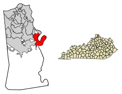
Location in Kenton County, Kentucky
|
|
| Country | United States |
| State | Kentucky |
| County | Kenton |
| Incorporated | 1972 |
| Area | |
| • Total | 5.45 sq mi (14.11 km2) |
| • Land | 5.24 sq mi (13.57 km2) |
| • Water | 0.21 sq mi (0.53 km2) |
| Elevation | 817 ft (249 m) |
| Population
(2020)
|
|
| • Total | 922 |
| • Density | 175.95/sq mi (67.94/km2) |
| Time zone | UTC-5 (Eastern (EST)) |
| • Summer (DST) | UTC-4 (EDT) |
| ZIP code |
41015
|
| Area code(s) | 859 |
| FIPS code | 21-67602 |
| GNIS feature ID | 2405385 |
Ryland Heights is a small city in Kenton County, Kentucky, in the United States. It is known as a "home rule-class city," which means it has its own local government. In 2020, the population of Ryland Heights was 922 people.
Contents
About Ryland Heights
Ryland Heights is located in the eastern part of Kenton County. It sits next to the Licking River on its eastern side. This river also forms the border with Campbell County.
Nearby Cities
Ryland Heights is surrounded by several other cities:
- To the west, you'll find Independence and Covington.
- Fairview is to the northwest.
- Taylor Mill is located to the north.
Getting Around
Kentucky Route 177 is a main road that goes through Ryland Heights. If you travel north on this road, it's about 10 miles (16 km) to downtown Covington. If you head south, it's about 17 miles (27 km) to Butler.
Land and Water
The United States Census Bureau reports that Ryland Heights covers a total area of about 5.45 square miles (14.11 square kilometers). Most of this area is land, about 5.24 square miles (13.57 square kilometers). A small part, about 0.21 square miles (0.53 square kilometers), is water.
Population Changes
The number of people living in Ryland Heights has changed over the years. Here's a quick look at the population counts from different years:
| Historical population | |||
|---|---|---|---|
| Census | Pop. | %± | |
| 1980 | 252 | — | |
| 1990 | 279 | 10.7% | |
| 2000 | 799 | 186.4% | |
| 2010 | 1,022 | 27.9% | |
| 2020 | 922 | −9.8% | |
| U.S. Decennial Census | |||
In 2000, there were 799 people living in the city. These people lived in 293 households. A household is a group of people living together in one home. Most households, 225 of them, were families.
Who Lives Here?
The population of Ryland Heights is made up of people from different backgrounds. In 2000, most residents were White. A small number of people identified as African American, Native American, or from two or more races.
Households and Families
About 29.7% of the households in 2000 had children under 18 years old living there. Many households (64.2%) were married couples living together. The average household had about 2.73 people. The average family had about 3.13 people.
Age Groups
The people in Ryland Heights are of different ages. In 2000:
- 24.3% were under 18 years old.
- 7.9% were between 18 and 24 years old.
- 29.2% were between 25 and 44 years old.
- 27.5% were between 45 and 64 years old.
- 11.1% were 65 years or older.
The average age of people in the city was 39 years old.
See also
 In Spanish: Ryland Heights (Kentucky) para niños
 | Bessie Coleman |
 | Spann Watson |
 | Jill E. Brown |
 | Sherman W. White |

