Fort Wright, Kentucky facts for kids
Quick facts for kids
Fort Wright, Kentucky
|
|||
|---|---|---|---|
|
|||

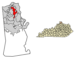
Location in Kenton County, Kentucky
|
|||
| Country | United States | ||
| State | Kentucky | ||
| County | Kenton | ||
| Area | |||
| • Total | 3.44 sq mi (8.90 km2) | ||
| • Land | 3.40 sq mi (8.80 km2) | ||
| • Water | 0.04 sq mi (0.10 km2) | ||
| Elevation | 801 ft (244 m) | ||
| Population
(2020)
|
|||
| • Total | 5,851 | ||
| • Estimate
(2022)
|
5,819 | ||
| • Density | 1,721.39/sq mi (664.54/km2) | ||
| Time zone | UTC-5 (Eastern (EST)) | ||
| • Summer (DST) | UTC-4 (EDT) | ||
| ZIP codes |
41011, 41017
|
||
| Area code(s) | 859 | ||
| FIPS code | 21-28612 | ||
| GNIS feature ID | 2403651 | ||
Fort Wright is a city in Kenton County, Kentucky, in the United States. It is known as a "home rule-class city." This means it has the power to manage its own local affairs. In 2020, about 5,851 people lived there. Fort Wright is also part of the larger Cincinnati metropolitan area.
Contents
Where is Fort Wright?
Fort Wright is located in the northern part of Kenton County. It shares borders with several other communities. To the north is Ludlow. To the northeast, you'll find Park Hills. Kenton Vale is to the east. Covington is to the east and southeast. To the southwest are Edgewood and Crestview Hills. Finally, Fort Mitchell is to the west.
Two major highways, Interstate 75 and Interstate 71, run through the middle of the city. You can get on or off these highways at Exit 189 (Kyles Lane). If you drive northeast on the freeway, you'll reach downtown Cincinnati in Ohio in about 4 miles (6 km). Driving southwest for about 16 miles (26 km) will take you to where the two interstates split near Walton.
The United States Census Bureau says that Fort Wright covers a total area of 3.4 square miles (8.7 km2). Most of this is land, with only about 0.04 square miles (0.1 km2) being water. This means about 1.10% of the city's area is water.
A Look at Fort Wright's History
The area where Fort Wright now stands was once important during the American Civil War. It was the site of one of the forts built to help protect the city of Cincinnati. The city of Fort Wright was officially created in 1941. It was named after Major General Horatio Gouverneur Wright. He was an engineer in the Union Army during the Civil War.
Over the years, Fort Wright grew by adding nearby communities. It added Lookout Heights in 1937. South Hills joined in 1949, and Lakeview became part of Fort Wright in 1960.
Population and People
| Historical population | |||
|---|---|---|---|
| Census | Pop. | %± | |
| 1950 | 594 | — | |
| 1960 | 2,184 | 267.7% | |
| 1970 | 4,819 | 120.7% | |
| 1980 | 4,481 | −7.0% | |
| 1990 | 6,570 | 46.6% | |
| 2000 | 5,681 | −13.5% | |
| 2010 | 5,723 | 0.7% | |
| 2020 | 5,851 | 2.2% | |
| 2022 (est.) | 5,819 | 1.7% | |
| U.S. Decennial Census | |||
In 2000, the city had 5,681 people living in 2,430 households. About 1,569 of these were families. The population density was about 1,642.1 inhabitants per square mile (634.0/km2) people per square mile. There were also 2,573 housing units.
Most of the people living in Fort Wright were White (97.32%). A smaller number were African American (0.99%) or Asian (0.79%). About 0.69% of the population was Hispanic or Latino.
About 25.9% of households had children under 18 living with them. Many households (52.8%) were married couples living together. About 30.9% of all households were made up of people living alone.
The average age of people in Fort Wright was 39 years old. About 21.5% of the population was under 18. About 15.5% were 65 years old or older.
Education in Fort Wright
Most of the schools in Fort Wright are part of the Kenton County School District. However, some parts of the city are in the Beechwood Independent School District. Other areas are served by the Covington Independent School District.
See also
 In Spanish: Fort Wright (Kentucky) para niños
 | Laphonza Butler |
 | Daisy Bates |
 | Elizabeth Piper Ensley |


